
| Online ISSN | : | 2953-7991 |
| Print ISSN | : | 1829-1759 |

«ԵՊՀ Գիտական տեղեկագիր. Երկրաբանական և աշխարհագրական գիտություններ» պարբերականի նպատակն է տպագրել բնօրինակ գիտահետազոտական աշխատանքներ և հետազոտական հոդվածներ երկրաբանության և աշխարհագրության բոլոր ոլորտներում: Պարբերականն ընդունում է նաև գրախոսական հոդվածներ, կարճ հաղորդակցություն, կոնֆերանսի նյութեր, թեկնածուական և դոկտորական թեզեր և այլ հոդվածներ՝ արդյունքների, փորձերի և օրինակների մանրամասն ներկայացմամբ: Նպատակներից մեկն է արտացոլել Հայաստանում երկրաբանության և աշխարհագրության բոլոր ոլորտներում կատարվող հետազոտությունների առաջընթացը և միջազգային ֆորումի միջոցով խթանել դրա հետագա զարգացումները։
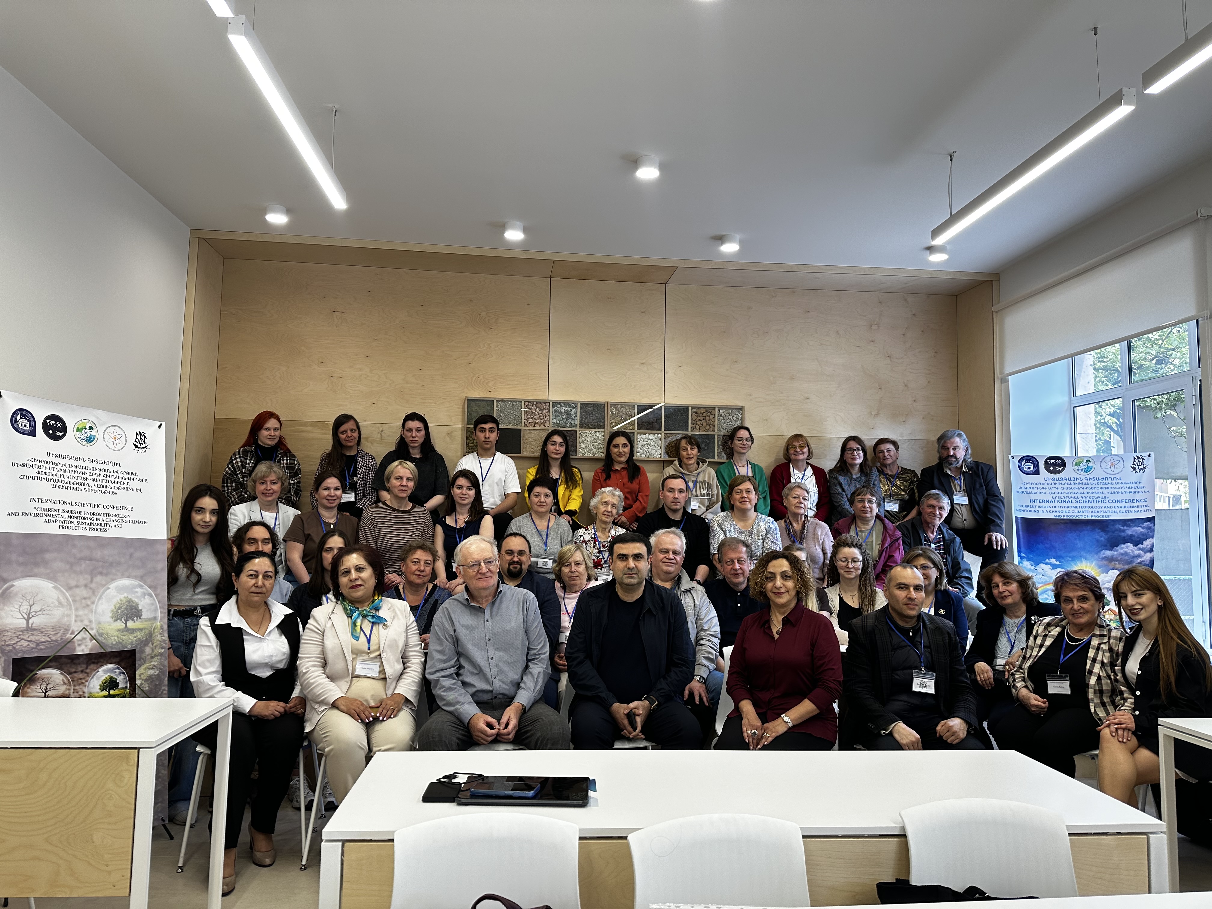
Անտառագետի, Ջրաբանի և Օդերևութաբանի մասնագիտական օրերի առթիվ ԵՊՀ աշխարհագրության և երկրաբանության ֆակուլտետի նախաձեռնությամբ, ՀՀ ԲԳԿ Բարձրագույն կրթության և գիտության կոմիտեի կողմից (Հետազոտական նախագիծ № 24WS-1E035) ֆինանսական աջակցությամբ 2026թ․ մայիսի 04-ից 07-ին անցկացվեց «Հիդրոօդերևութաբանության և շրջակա միջավայրի մոնիթորինգի արդի հիմնախնդիրները փոփոխվող կլիմայի պայմաններում. հարմարվողականություն, կայունություն և արտադրական գործընթաց» խորագրով միջազգային գիտաժողովը: Գիտաժողովի նպատակն է քննարկել հիդրոօդերևութաբանության, շրջակա միջավայրի մոնիտորինգի և էկոլոգիական անվտանգության ապահովման բնագավառում հիմնարար և կիրառական գիտական հետազոտությունների զարգացման ձեռքբերումներն ու հեռանկարները, բացահայտել և վերհանել հիդրոօդերևութաբանության ոլորտում ծառացած գերակա խնդիրները, զարգացման օրինաչափությունները և հեռանկարները, գնահատել վերջինիս դերը տարածաշրջանի սոցիալ-տնտեսական խնդիրների լուծման մեջ, վերլուծել և գնահատել շրջակա միջավայրի արդի վիճակը, կլիմայի փոփոխության հիմնահարցերը: Գիտաժողովի ընթացքում կքննարկվեն նաև ժամանակակից հասարակության զարգացման և էկոհամակարգի իրավական կարգավորման տնտեսակառավարման հիմնախնդիրները, ինչպես նաև բնապահպանական և հիդրոօդերևութաբանական կրթության գերակա խնդիրները:
Կլիմայի փոփոխությունը հանգեցնում է երկրահամակարգերի վերակառուցման՝ ստեղծելով ռիսկեր շրջակա միջավայրի և ենթակառուցվածքների համար: Հետևաբար, կլիմայի կանխատեսումը պետք է ներառի տեղեկատվություն էքստրեմալ իրադարձությունների մասին: Հազվադեպ, ամենախոշոր և ամենաինտենսիվ էքստրեմալ երևույթնները լիովին չեն վերարտադրվում Երկրային համակարգի մոդելներում (ԵՀՄ): Դրանք առանձնանում են մյուսներից ոչ միայն իրենց ուժեղ կողմերով, այլ նաև այն պատճառով, որ չեն տեղավորվում հավանականության բաշխման ֆունկցիայի (ՀԲՖ) բազայի մեջ։ Նման իրադարձությունները երբեմն անվանում են «սև կարապներ» կամ «վիշապներ»։ Այս իրադարձությունների մոդելավորման մեջ չվերարտադրվելու պատճառը, հավանաբար, պայմանավորված է ԵՀՄ-ի անբավարար տարածական լուծաչափով։ Հետևաբար, անհրաժեշտ է մշակել մասնագիտացված մոտեցում, որը կներառի կլիմայի մոդելավորման արդյունքները ոչ ստացիոնար էքստրեմալ երևույթների վիճակագրական տեսության մեթոդաբանության մեջ։ Էքստրեմալ երևույթների ՀԲՖ-ները նկարագրող դասական վիճակագրական տեսությունը կարող է ընդհանրացվել ոչ ստացիոնար պրոցեսների համար։ Կլիմայի կանխատեսման մեջ ոչ ստացիոնար ՀԲՖ-ների պարամետրերը գնահատվում են կլիմայի մոդելավորման տվյալների հիման վրա։ Սակայն, այս մոտեցումը երաշխավորում է միայն հավանականության խտության ֆունկցիայի «ճիշտ» էքստրեմումների կանխատեսումը, ինչը նշանակում է, որ այն չի վերացնում «սև կարապների» (կամ «վիշապների») խնդիրը։ Այլընտրանք է ժամանակի (կամ տարածության) միջինացված ցուցանիշների օգտագործումը, որոնց համար հազվադեպ իրադարձությունների առաջացումը կարևոր չէ դրանց հավանականության խտության ֆունկցիայի համար։ Սա հնարավոր է կլիմայական պրոցեսների ֆիզիկայի շնորհիվ, որտեղ անոմալիաները այնքան էլ նշանակալի չեն, որքան, օրինակ, ֆինանսական մաթեմատիկայում։
Ներկայացվում են Մոսկվայի մթնոլորտի ակուստիկ զոնդավորման հիմնական արդյունքները: METEK (Գերմանիա) ընկերության կողմից արտադրված MODOS Doppler SODAR-ը գործում է Մոսկվայի համալսարանում 2004 թվականից: Դրա աշխատանքային հաճախականությունը 2000 Հց է, զոնդավորման միջակայքը՝ 40-ից մինչև 500 մ, ժամանակային և տարածական լուծաչափը՝ համապատասխանաբար 10 րոպե և 20 մ: Բազմամյա զոնդավորման արդյունքում (20 տարի) ստացվել են քամու արագության և ուղղության ավելի քան 7 մլն անհատական արժեքներ յուրաքանչյուր մակարդակի վրա: Քամու արագության տարեկան ընթացքը բնութագրվում է առավելագույն արժեքներով աշնանը և ձմռանը, իսկ նվազագույն՝ ամռանը։ Դա բացատրվում է Մոսկվայում տարվա ցուրտ եղանակին ցիկլոնների ծայրամասում հաճախակի ինտենսիվ գրադիենտային հոսքերով։ Քամու արագության V օրական ընթացքը բնութագրվում է օդի մինչև 40-60 մ շերտում ցերեկային առավելագույնով և գիշերային նվազագույնով, և հակառակը՝ ցերեկային նվազագույնով և գիշերային առավելագույնով՝ 140-160 մ-ից ավելի բարձրություններում։ Այսպիսով, 80-ից 120 մ շերտը մոտավորապես համապատասխանում է քամու շրջանառության բարձրությանը. այստեղ օրական ընթացքը թույլ է արտահայտվում և բնութագրվում է առավոտյան նվազագույնով։ Մոսկվայում մինչև 500 մ բարձրության օդի շերտում միջինը 10 րոպե-ի ընթացքում քամու առավելագույն արագությունը հազվադեպ կարող է հասնել 30-35 մ/վրկ-ի, երբ համընկնում են հետևյալ երկու պայմաններ. Մոսկվան գտնվում է խորը ցիկլոնի ծայրամասում, և միևնույն ժամանակ առկա է ցածր մակարդակի վրա շիթային հոսք։ V բազմամյա միջին պրոֆիլի քվազիգծային հատվածի վերին սահմանը կիսալոգարիթմական կոորդինատներում կազմում է 40-60 մ (դա կարելի է ընդունել որպես օդի գետնամերձ շերտի բարձրություն, եթե միջին պայմանները մոտ են չեզոք շերտավորմանը), խորդուբորդության պարամետրը մոտ 5 մ է։ Օդի գետնամերձ շերտում քամու հաստատուն ուղղության չափանիշի համաձայն, «մեռյալ գոտու» (40 մ) վրա քամու ուղղության միջին ամսական պրոֆիլներում դրա բարձրությունը մոտ երեք դեպքից մեկում կազմում է 60 մ (երբեմն՝ 80 կամ նույնիսկ 100 մ): Այս մոտեցմանը հետևելով՝ օդի գետնամերձ շերտի միջին բարձրությունը, հավանաբար, մի փոքր պակաս է 50 մ-ից, ինչը մոտ է առաջին գնահատականին։ Վերջին 20 տարիների ընթացքում քամու ուղղությունը միջին հաշվով քամու վարդում ունի կայուն հարավարևմտյան ռեժիմ։ Մոսկվայի վրա քամու ամենահազվադեպ ուղղությունը հյուսիս–հյուսիս-արևելքն է։ 40–500 մ բարձրության Էկմանի շերտում քամու աջ շրջադարձը 20º է։ Աշխատանքը կատարվել է Ռուսաստանի գիտական հիմնադրամի ֆիանսավորման աջակցության շրջանակներում, № 26-27-20046 նախագիծ։
Հոդվածում ուսումնասիրվում են Արևմտյան Սիբիրում քամու արագության փոփոխությունների ֆիզիկական, աշխարհագրական և կլիմայական պայմանները: Ներքնոլորտում (տրոպոսֆերայում) քամու ուղղությունը և արագությունը մթնոլորտային շրջանառության և տարածքի տարածաշրջանային առանձնահատկությունների ազդեցության արդյունք են: Փոփոխականության միտումները տարբերվում են աշխարհի տարբեր տարածաշրջաններում։ Քամու ռեժիմի փոփոխությունը կարող է վկայել ճառագայթային հաշվեկշռի փոփոխության մասին, որն ուղեկցվում է ուսումնասիրվող տարածաշրջանի վրա մթնոլորտային ճնշման սյան փոփոխությամբ։ Աշխատանքում ներկայացվում է Արևմտյան Սիբիրի ներքնոլորտում քամու արագության բազմամյա փոփոխությունը։ Վերլուծվել են Արևմտյան Սիբիրի չորս կայանների (Ալեքսանդրովսկոյե, Բարաբինսկ, Նովոսիբիրսկ և Կոլպաշևո) երկրի և 850, 700, 500 և 300 հՊա ստանդարտ իզոբար մակերևույթների տվյալները 1975-2020 թվ.-ի համար։ Ուսումնասիրությունը ցույց է տալիս, որ ժամանակային փոփոխությունը սինխրոն է ներքնոլորտի բոլոր շերտերում և պայմանավորված է մակրորջանառական գործընթացների տատանումներով։ Բոլոր կայաններում բոլոր մակարդակներում դիտվում է քամու արագության նվազման միտում։ Ավելին, Արևմտյան Սիբիրի հյուսիսային մասում քամու արագության նվազումը վիճակագրորեն նշանակալի է ամբողջ ներքնոլորտում։ Հյուսիսային տարածաշրջանում քամու արագությունն ավելի զգալիորեն նվազել է 850–700 հՊա բարձրություններում, քան հարավայինում։ Երկրի մակերևույթին և ներքնոլորտում քամու արագության կոռելյացիայի գործակիցները մեծ են և վիճակագրորեն նշանակալի՝ առնվազն 99% հավանականությամբ դիտարկվող երեք կայաններում։ Հյուսիսային լայնություններում ներքնոլորտային քամու արագության նվազումը կարող է կապված լինել կլիմայի շարունակական տաքացման հետ, որը հատկապես նկատելի է հյուսիսային շրջաններում, ինչը հանգեցրել է Արևմտյան Սիբիրի հյուսիսային և կենտրոնական տարածաշրջանների միջև ճնշման գրադիենտների նվազմանը։ Արևմտյան Սիբիրի հարավային մասում քամու արագության նվազումն ավելի ցայտուն է արտահայտված երկրի մակերեևույթի մոտ։ Քամու արագության նման փոփոխականությունը կարող է ազդել ուսումնասիրվող տարածքում կլիմայի փոփոխության վրա։
Ժամանակակից կլիմայի փոփոխությունը բնութագրվում է գլոբալ միջին ջերմաստիճանի արագ աճով, որն արդեն բարձրացել է մոտ 1.3–1.5℃-ով՝ նախարդյունաբերական մակարդակի համեմատ։ Այս տաքացմանը զուգընթաց, զգալիորեն աճել են էքստրեմալ եղանակային երևույթների, այդ թվում՝ ջերմային ալիքների և առատ տեղումների հաճախականությունն ու ինտենսիվությունը։ Չնայած կլիմայի փոփոխության վրա ազդում են բնական գործոններ, ինչպիսիք են ուղեծրային ազդեցությունը, արեգակնային ակտիվությունը, հրաբխային ժայթքումները և օվկիանոսային շրջանառությունը, մթնոլորտում ջերմոցային գազերի (ՋԳ)՝ հիմնականում CO2-ի և CH4-ի, կոնցենտրացիաների աճը դիտվում է որպես ներկայիս կլիմայի փոփոխության հիմնական շարժիչ ուժ։ Այս ուսումնասիրությունում վերլուծվում է ցամաքային և օվկիանոսային էկոհամակարգերի կողմից CO2-ի և CH4-ի արտանետումների և կլանման դինամիկան 21-րդ դարում՝ կենտրոնանալով վերջին գնահատականների, տարածական և ժամանակային փոփոխության և հիմնական միտումների վրա։ Հատուկ ուշադրություն է դարձվում ջերմոցային գազերի հոսքերի գնահատման մեթոդների և կլիմայի փոփոխության մեղմման և հարմարվողականության ռազմավարությունների դերի վրա։ IPCC գույքագրման մեթոդաբանությունը կիրառում է ներքևից վերև մոտեցում՝ հիմնված հողօգտագործման, գյուղատնտեսության, արդյունաբերության և էներգիայի սպառման վիճակագրական տվյալների վրա՝ զուգակցված արտանետումների ստանդարտացված գործակիցների հետ։ Կենսաերկրաքիմիական մոդելները (ներառյալ CESM, LPJ, ORCHIDEE և JULES) սահմանափակում են բուսականության, հողերի, օվկիանոսների և մթնոլորտի փոխազդեցությունները։ Ինվերսիայի մոդելավորումը օգտագործում է OCO-2, GOSAT և TROPOMI արբանյակային դիտարկումները մթնոլորտային տեղափոխությունների մոդելների հետ միասին՝ մակերևութային ջերմոցային գազերի հոսքերը գնահատելու համար։ Մեքենայական ուսուցման մեթոդները ավելի ու ավելի հաճախ են օգտագործվում՝ ջերմոցային գազերի հոսքերի և շրջակա միջավայրի գործոնների միջև ոչ գծային կապերը բացահայտելու համար՝ օգտագործելով դիտարկումների տվյալներ մեծ բազա։ Ժամանակակից ջերմոցային գազերի մոնիթորինգի համակարգերը ինտեգրում են դիտարկումները՝ բազմաթիվ տարածական մասշտաբներով։ CO2-ի և CH4-ի հոսքերի տեղական չափումները ստացվում են՝ օգտագործելով մրրկային կովարիացիոն մեթոդներ, խցիկային մեթոդներ և անօդաչու թռչող սարքերի դիտարկումներ, որոնք ապահովում են մոդելի կարգավորման և վավերացման համար անհրաժեշտ տվյալները։ Տարածաշրջանային և գլոբալ գնահատականները ստացվում են կենսաերկրաքիմիական և ինվերսիայի մոդելավորման մեթոդների միջոցով՝ հիմնված արբանյակային դիտարկումների վրա։ Երկրային չափումների, հեռազգացման և մոդելավորման ինտեգրումը զգալիորեն բարելավում է մթնոլորտի, ցամաքի և օվկիանոսի էկոհամակարգերի միջև ջերմոցային գազերի փոխանակման մեր ըմբռնումը։ Համաձայն Գլոբալ Ածխածնային Բյուջեի՝ համաշխարհային օվկիանոսը 2006-2023 թվ.-ի ընթացքում տարեկան կլանել է մոտ 2.2–3.0 ԳտԿ մարդածին CO2, մինչդեռ ցամաքային էկոհամակարգերը տարեկան միջինում կլանել են 2.5–3.5 ԳտԿ մարդածին CO2, չնայած կլիմայական պայմանների, հողօգտագործման խախտումների և փոփոխության պատճառով պայմանավորված միջտարեկան ավելի մեծ փոփոխությամբ։ Այս ուսումնասիրությունը ընդգծում է բնապահպանության վրա հիմնված լուծումների կարևորությունը, ներառյալ անտառների, ջրա-ճահիճների, մարգագետինների պահպանությունն ու վերականգնումը՝ կլիմայի փոփոխության մեղմման և ածխածնի կլանման համար։
Թվային մթնոլորտային մոդելավորումը եղանակի բոլոր կանխատեսումների հիմքն է՝ ժամայինից մինչև սեզոնային, ինչպես նաև կլիմայի փոփոխությունների համար: Եղանակի ամենօրյա օպերատիվ կանխատեսման համար տարբեր երկրներում մշակվել են մոդելավորման և տվյալների մշակման հատուկ տեխնոլոգիական համակարգեր՝ օգտագործելով հաշվարկային հսկայական հզորություններ ունեցող գերհամակարգիչներ։ Համաշխարհային օդերևութաբանական կազմակերպության (ՀՕԿ) պահանջների համապատասխան թվային կանխատեսումներ են տրամադրում համաշխարհային և տարածաշրջանային մասնագիտացված օդերևութաբանական կենտրոնները: Մոսկվան (որպես Ռուսաստանի հիդրոօդերևութաբանական կենտրոն) ունի երկու կենտրոն՝ համաշխարհային և տարածաշրջանային: Մոսկվայի տարածաշրջանային մասնագիտացված օդերևութաբանական կենտրոնում գրեթե 20 տարի մշակվում է COSMO-Ru բազմամասշտաբ կանխատեսման համակարգ: Ներկայումս տարածաշրջանային կանխատեսումների լայնածավալ հաշվողական տիրույթը (2025 թվականից՝ COSMO-Ru համակարգի ICON կոնֆիգուրացիայում ICON մոդելի ներդրումից հետո) ներառում է Հյուսիսային կիսագնդի ամբողջ արտաարևադարձային գոտին: Կանխատեսումների շարքերը թողարկվում են օրական չորս անգամ՝ 6,6 կմ ցանցային միջակայքով մինչև 120 ժ, իսկ Ռուսաստանի եվրոպական մասի և հարակից շրջանների համար՝ 2,2 կմ ցանցային միջակայքով մինչև 48 ժ։ Ներկայացվում է թվային մթնոլորտային մոդելավորման ներկայիս վիճակի և զարգացման միտումների համառոտ նկարագրությունը Համաշխարհային օդերևութաբանական կազմակերպության (WMO) եղանակի թվային կանխատեսման առաջատար կենտրոններում: Դիտարկվում է Ռուսաստանի հիդրոօդերևութաբանական կենտրոնում ICON և COSMO մոդելների հիման վրա մշակված COSMO/ICON-Ru բարձր թույլտվությամբ կանխատեսման համակարգը, ինչպես նաև դրա մշակումը որոշ հաշվողական տիրույթների համար, ներառյալ Հայաստանի Հանրապետության տարածաշրջանը: Շեշտվում է ոչ հիդրոստատիկ մոտարկման և կոնվեկտիվ-լուծաչափով ցանցերի օգտագործման կարևորությունը տարածաշրջանային կոնֆիգուրացիաներում, ինչպես նաև բարձր թույլտվությամբ մոդելային արտադրանքի մեկնաբանման առանձնահատկությունները:
21-րդ դարի կեսերին Ռուսաստանում կենսակլիմայական պայմանները գնահատելու համար օգտագործվել է Համընդհանուր Ջերմային Կլիմայական Ինդեքս (UTCI): Ապագա կլիմայական պայմանների (2040–2059թթ․) համար գնահատվել են Համընդհանուր Ջերմային Կլիմայական Ինդեքսի սեզոնային և տարածաշրջանային առանձնահատկությունները «մեղմ» (SSP1-2.6) և «խիստ» (SSP5-8.5) սցենարների համար։ UTCI-ի միջին օրական արժեքները հաշվարկելու համար օգտագործվել է BioKlima 2.6 ծրագրային փաթեթը և CMIP6-ին մասնակցող երեք մոդելների օրական տվյալները՝ Ռուսաստանի գիտությունների ակադեմիայի Մարչուկի հաշվողական մաթեմատիկայի ինստիտուտի, Հադլիի օդերևութաբանական կենտրոնի և Մաքս Պլանկի օդերևութաբանության ինստիտուտի։ Ապագա կլիմայական պայմաններում Ռուսաստանում երկու սցենարների դեպքում էլ կշարունակեն գերակշռել ցուրտ սթրեսի պայմանները։ Ձմռանը (հունվար) գրեթե ամբողջ տարածքում կդիտվի տարբեր աստիճանի ցուրտ սթրես: Ամռանը (հուլիս) Ռուսաստանի մեծ մասում կդիտվեն ջերմային սթրեսից զուրկ պայմաններ, մինչդեռ հարավում կդիտվեն հարմարավետ պայմաններ: 21-րդ դարի կեսերին (2040–2059թթ․) Ռուսաստանում կենսակլիմայական պայմանների հնարավոր ապագա փոփոխությունների գնահատումը երկու սցենարների դեպքում էլ ցույց է տվել, որ երկրի հարավային եվրոպական մասում, ինչպես նաև հարավային և կենտրոնական Սիբիրում, մասնավորապես SSP5-8.5 սցենարի դեպքում, նկատվում է ուժեղ ցուրտ սթրեսի օրերի թվի նվազման և ջերմային սթրեսի օրերի թվի զգալի աճի միտում։ Ռուսաստանի տարածքի մեծ մասում կաճի UTCI դասակարգմամբ «առանց ջերմային սթրեսի» օրերի տոկոսը։ Ձևավորվող միտումները կնպաստեն երկրի հյուսիսում և արևելքում ամենավատ պայմաններ ունեցող շրջաններում կենսակլիմայի լավացմանը և հարավում ամենաբարենպաստ շրջաններում պայմանների վատթարացմանը՝ ջերմային սթրեսի օրերի թվի աճի պատճառով։
Հյուսիսային Կովկասի բնական միջավայրի մասին մեր ներկայիս պատկերացումները դարերի ընթացքում տևած լայնածավալ դիտարկումների արդյունք են: 18-րդ դարի արշավախմբերը նշանակալի ներդրում են ունեցել Հյուսիսային Կովկասի կլիմայի ուսումնասիրության մեջ: Հյուսիսային Կովկասի կլիմայի մասին տեղեկատվությունը սկսեց ակտիվորեն լուսաբանվել 19-րդ դարում Ռուսական կայսերական աշխարհագրական ընկերության Կովկասյան բաժնի գրառումներում և զեկույցներում (Կովկասի հանքային ջրերի առանձին տարածաշրջանների կլիմայական բնութագրերում, Նախակովկասի շրջաններում տեղումներին նվիրված աշխատություններում և այլն [1, 2]): 19-րդ դարում առաջարկվեց միջոցառումներ բնության բարելավման և պահպանման համար՝ ստեղծվեց բազմաթիվ օդերևութաբանական կայաններ՝ եղանակը վերահսկելու և հնարավոր բնական աղետները կանխելու համար։ Ռուս կլիմայագետ Ա.Ի. Վոեյկովը (1842–1916) նշանակալի ներդրում է ունեցել Հյուսիսային Կովկասի և ընդհանրապես Կովկասի կլիմայի ուսումնասիրության գործում։ Գիտական հողագիտության հիմնադիր Վ.Վ. Դոկուչաևը (1846–1903) Կովկասի հողերի վերաբերյալ իր աշխատություններում տեղեկություններ է տրամադրում Հյուսիսային Կովկասին բնորոշ կլիմայական առանձնահատկությունների մասին։ 19-րդ դարի վերջին 20 տարվա դիտարկումների հիման վրա կազմվել է Եվրոպական Ռուսաստանի գետավազաններում ամսական և տարեկան տեղումների բաշխման ատլաս (Ա.Ա. Տիլո, 1839–1899): Հյուսիսային Կովկասի կլիմայի ուսումնասիրությունները 19-րդ դարից առաջ և այդ ընթացքում հիմնականում նկարագրական էին և մասամբ ընդհանրացնող։ Այնուամենայնիվ, առկա դիտարկումների արդյունքները հիմք դրեց կլիմայի համապարփակ ուսումնասիրության համար: Ռուսական կայսերական աշխարհագրական ընկերության Կովկասի բաժինը կարևոր ներդրում է ունեցել կլիմայի հետազոտությունների գործում՝ գիտական հանրությանը հնարավորություն տալով ծանոթանալ Հյուսիսային Կովկասի կլիմայի վերաբերյալ նորարարական հետազոտություններին։
Գլոբալ մոդելների արդյունքները կատարելագործող մթնոլորտային մոդելավորման տարածաշրջանային համակարգերը ներկայումս ակտիվորեն օգտագործվում են որպես առաջիկա օրերի և ժամերի եղանակի թվային կանխատեսման միջոց։ Օգտագործելով ոչ հիդրոստատիկ մոտեցում և մի քանի կիլոմետր կամ պակաս քայլով ցանց, այս համակարգերը ոչ միայն մանրամասնորեն հաշվի են առնում տեղանքի բարդ աշխարհագրական առանձնահատկությունները, այլև կարող են իրատեսորեն կանխատեսել բարդ եղանակի ձևավորման մեխանիզմները, այդ թվում՝ կոնվեկցիայի հետ կապվածները: Հոդվածում նեկայացվում է տարածաշրջանային տվյալների յուրացման և հաջորդ 12 ժամվա թվային կանխատեսումների ժամային թարմացումների համար անընդհատ գործող համակարգի նկարագրությանը և արդյունքների վերլուծությանը։ Այն հիմնված է Ռուսաստանի Հիդրոօդերևութաբանական կենտրոնում մշակված COSMO-Ru2By կոնվեկտիվ մոդելի կոնֆիգուրացիայի վրա՝ 2.2 կմ հորիզոնական ցանցային քայլով [1]: Օգտագործվում են օդերևութաբանական կայաններից և Դոպլերային ռադարներից ստացված դիտարկումների տվյալները, որոնցից մի քանիսը հասանելի չեն միջազգային փոխանակման համար [2]: Օգտագործված մոտեցումը իրականացվել է նմանատիպ համակարգերի մշակման համաշխարհային պրակտիկային համապատասխան՝ բարձր թույլատրությամբ արագ թարմացում (HRRR) ԱՄՆ-ի շրջակա միջավայրի կանխատեսման ազգային կենտրոններում (NCEP) և արագ թարմացման ցիկլ (RUC) Գերմանիայի օդերևութաբանական ծառայությունում (DWD): Մշակված համակարգը ապացուցել է իր արդյունավետությունը արագ զարգացող վտանգավոր երևույթների կանխատեսման, ինչպես նաև դիտարկումների ցանցի լուծաչափը զգալիորեն գերազանցող լուծաչափով (ինչը կարող է հիմք հանդիսանալ բարձր լուծաչափով վերավերլուծություններ ստեղծելու համար) օդերևութաբանական վիճակի դաշտերի մոնիթորինգում:
Հոդվածում ներկայացված են խառը փշատերև-մանրատերև անտառում ածխաթթու գազի (CO2 հոսքերի) միջտարեկան փոփոխության ուսումնասիրության արդյունքները, որը գտնվում է Լոմոնոսովի անվան Մոսկվայի պետական համալսարանի ուսումնական և փորձարարական հողաէկոլոգիական կենտրոնում: 2010–2025 թվ.-ի համար էկոհամակարգի ածխածնային հաշվեկշիռը մոդելավորելու համար օգտագործվել է Forest-DNDC դինամիկ մոդելը, որը թույլ է տվել վերլուծել կլիմայական գործոնների (ջերմաստիճան և տեղումներ) ազդեցությունը հողի, բուսականության և մթնոլորտի միջև ածխածնի փոխանակման վրա: Մոդելի համարժեքությունը ստուգվել է՝ այն համեմատելով պուլսացիոն չափումների արդյունքների հետ, որոնք հաստատել են դրա կիրառելիությունը անտառային էկոհամակարգերում CO2 ինտեգրալ հոսքերի հաշվարկման համար: Մոդելի հաշվարկները բացահայտել են հողում օրգանական ածխածնի կուտակման կայուն միտում՝ տարեկան միջինը 170-ից 230 կգ C/հա, որը ուղեկցվում է անտառային էկոհամակարգի ածխածնի ընդհանուր կլանման կարողության չափավոր նվազմամբ: Ջերմաստիճանի բարձրացումը տարեկան միջինը 1%, թուլացնում է ածխածնի կլանումը: Առանձին տարիների էկոհամակարգը ծառայում է որպես CO2-ի աղբյուր՝ տարեկան արտանետելով 400-ից 800 կգ C/հա:
Եղանակի թվային կանխատեսման համակարգերը պահանջում են նախնական տվյալներ, այդ թվում՝ երկրի մակերևույթի վիճակի վերաբերյալ տեղեկատվություն: Ձյան ծածկույթի տվյալները պարտադիր են, որոնցից ձյան գծի դիրքը կարևոր է առաջիկա օրերի եղանակի թվային կանխատեսման համար: Ներկայումս այս տվյալները հիմնված են արբանյակային չափումների վրա, որոնք ճշգրտվել են՝ հաշվի առնելով բաց տարածքներում տեղակայված օդերևութաբանական կայաններից ստացված ձյան շերտի բարձրության օրական տվյալները։ Անտառներում ծառերի պսակները կարող են ձյունից զերծ լինել, քանի որ ցուրտ ժամանակահատվածում ձյունը կարող է տեղափոխվել ճյուղերի տակ և մասամբ հալվել։ Դա կարող է հանգեցնել ծառերի պսակների և շրջակա օդի տաքացմանը։ Անտառային լանդշաֆտներում ձյան կուտակման և ուղղաձիգ վերաբաշխման գործընթացները, որպես կանոն, հաշվի չեն առնվում ժամանակակից կանխատեսման մոդելներում՝ ելակետային տվյալները մշակելիս։ Սա երբեմն հանգեցնում է մթնոլորտի ցածր մակարդակների համար ջերմաստիճանի մոդելային կանխատեսումների զգալի սխալների։ Ներկայացումը ներկայացնում է օրինակներ, թե ինչպես են ձյան ծածկույթի ելակետային տվյալները ազդում առաջիկա օրերի համար կանխատեսած օդերևութաբանական պարամետրերի վարքագծի վրա (օգտագործելով COSMO/ICON-Ru կանխատեսման համակարգը): Պարզվել է, որ օդի գետնամերձ ջերմաստիճանի, ամպամածության (հատկապես ցածր մակարդակի ամպամածության) և տեղումների ընդհանուր քանակի ու փուլերի կանխատեսումները առավել զգայուն են այս գործոնի նկատմամբ։ Գարնանը կանխատեսման ճշտության անկման քանակական գնահատականներ են ներկայացվում, երբ վերը նկարագրված գործոնները հաշվի չառնելը առավել նկատելի է։ Այս դեպքում, եթե ելակետային տվյալները ստեղծելիս հաշվի չի առնվում ձնազուրկ ծառերի պսակի գործոնը, կանխատեսվող մակերևույթի ջերմաստիճանը սովորաբար մնում է 0℃-ի վրա (ամբողջ ջերմությունը գնում է մոդելի բջջի մակերեսին ձյան հալեցման վրա)։ Դիտարկվում են ձնածածկույթի սահմանների վերաբերյալ տվյալների ճշգրտման ալգորիթմների առաջարկներ։
Տեսակների կլիմայական տիրույթների մաթեմատիկական մոդելավորումը կլիմայի փոփոխության էկոհամակարգերի և գյուղատնտեսության վրա հնարավոր ազդեցությունը գնահատելու հիմնական գործիք է: Այս ուսումնասիրությունը օգտագործում է RANGES համակարգը, որը, հիմնվելով դիտարկված կլիմայական տվյալների կամ կլիմայական մոդելի արդյունքների և կլիմայի կանխատեսողների արժեքների վրա, գնահատում է այն հավանականությունը, որ աշխարհագրական վայրը պատկանում է տվյալ տեսակի կլիմայական տարածման տարածաշրջանին կամ կլիմայական արեալին: Երկարաժամկետ միջինների վրա հիմնված մոտեցումներից տարբերվող այս ուսումնասիրությունը ստուգում է կլիմայի կանխատեսողների սահմանափակումները առանձին՝ դիտարկվող ժամանակահատվածում յուրաքանչյուր տարվա համար: Իտալական մորեխի և միջերկրածովյան մրգային ճանճի՝ երկու գյուղատնտեսական վնասատուների կլիմայական տիրույթները գնահատվում են 1990–1999, 2030–2039 և 2050–2059 թվականների կլիմայական պայմանների համար՝ կլիմայի փոփոխության մի շարք սցենարների դեպքում: Վնասատուների մեծ թվից այս երկու տեսակները համարվում են վտանգավոր կամ պոտենցիալ վտանգավոր Ռուսաստանի կլիմայական պայմաններում: Հաշվարկները կատարվել են՝ օգտագործելով Ռուսաստանի գիտությունների ակադեմիայի (ՌԳԱ) Մարչուկի անվան հաշվողական մաթեմատիկայի ինստիտուտում (ՌԳԱԻ) մշակված գլոբալ կլիմայական մոդելով ստացված կլիմայական տվյալները, որոնք թույլ են տվել գնահատել այս վնասատուների հետ կապված տարածական բաշխման և ռիսկի մակարդակների հնարավոր ապագա փոփոխությունները: Արդյունքները ցույց են տալիս իտալական մորեխի արեալի ընդհանուր հյուսիսային ընդլայնում, մասնավորապես՝ Եվրոպական Ռուսաստանում: Այնուամենայնիվ, կլիմայի փոփոխության որոշակի սցենարների դեպքում, Կենտրոնական Սև Երկրի որոշակի տարածքներում կանխատեսվում է այս արեալ մուտք գործելու հավանականության փոքր-ինչ նվազում: Միջերկրածովյան մրգային ճանճի համար, որի ներկայիս արեալը Ռուսաստանում հիմնականում սահմանափակվում է Սև ծովի ափով, 21-րդ դարի կեսերին սպասվում է դրա արեալի հյուսիսային և արևելյան ընդլայնում:
Ներկայացված են Վալդայի ազգային պարկի տարբեր մասերում գտնվող չոր հետանտառային մարգագետնային էկոհամակարգերի հինգ փորձարարական նմուշառման տեղամասերի ֆլորիստիկական կազմի երկարաժամկետ մոնիթորինգի տվյալները: Այս մարգագետինները ձևավորվել են դարավոր գյուղատնտեսական պրակտիկայի արդյունքում, ապա՝ արգելոցի և կլիմայի գլոբալ տաքացման պայմաններում։ Ցույց է տրվել, որ խոտհունձի, արածեցման և այրման բացակայության դեպքում մարգագետինները ցուցաբերում են համեմատաբար կայուն ֆլորիստիկական կազմ և առատ խոտածածկույթ, տեսանելի հաջորդական պրոցեսների բացակայություն և օտար տեսակների ներխուժման դիմադրողականություն։ Հայտնաբերվել են տեսակների քանակի, խոտածածկի առավելագույն բարձրության, մարգագետնային ֆիտոցենոզների պրոյեկտիվ ծածկույթի և տվյալ տարվա եղանակային պայմանների՝ սեզոնային ջերմաստիճանի, տեղումների և ձյան ծածկույթի խորության միջև կոռելյացիոն կապեր։ Պարզվել է, որ ջերմաստիճանի և տեղումների պարամետրերի տարբեր համադրությունները, որոնք կապված են ջերմության և խոնավության հետ, կարևոր դեր են խաղում բոլոր հինգ մարգագետնային փորձանմուշային տեղամասերում բուսածածկույթի տեսակային բազմազանության ձևավորման գործում։ Գերակշռում են ջերմաստիճանի հետ նշանակալի բացասական և խոնավության պայմանների հետ դրական կապերը։ Առավելագույն տեսակային բազմազանությունը, խոտաբույսերի և պրոյեկտիվ ծածկույթի առավելագույն բարձրությունը դիտվում են լավ խոնավության և ջերմաստիճաններով էքստրեմալ արժեքներ չունեցող տարիներին:
Ներկայացվում է Բելառուսի տարբեր տարածաշրջաններում և չորային Թարիմ նահանգի (Չինաստան) գետերի հոսքի վրա խոնավության ազդեցության ուսումնասիրությունը: Ուսումնասիրության օբյեկտներն են Բելառուսի տարբեր խոնավության մակարդակներով երեք հիդրոլոգիական շրջանները՝ խոնավ (Արևմտյան Դվինա), չափավոր խոնավ (Նեման) և չոր (Արևմտյան Բուգ), ինչպես նաև Թարիմ գետի անապատային գոգավորություն: Կլիմայի խոշորամասշտաբ տաքացումը հանգեցնում է օդի տարեկան միջին ջերմաստիճանի համատարած բարձրացմանը։ Տեղումների քանակի նվազման ընդհանուր ֆոնին (բացառությամբ Արևմտյան Բուգ տարածաշրջանի), դիտվում է գետերի տարեկան միջին շախսի նվազում։ Արևմտյան Դվինա տարածաշրջանում տեղումների տարեկան քանակի զգալի աճը հանգեցնում է տարածաշրջանի գլխավոր գետի ջրի տարեկան միջին ծախսի աննշան աճի։ Տաքացման ժամանակահատվածում տեղումների քանակի նվազման և օդի միջին ջերմաստիճանի բարձրացման հետ մեկտեղ դիտվում է ջրի տարեկան միջին ծախսի նվազման միտում։ Ստացվել են 1980-1922 թթ․ շրջանում օդի ջերմաստիճանի, 1960-2014 թվականների շրջանում տեղումների միտումների տվյալներ, ինչպես նաև ջրի տարեկան միջին ծախսերի և օդի տարեկան միջին ջերմաստիճանի ու տեղումների քանակի միջև կապի կոռելյացիայի գործակիցներ 1960-2014 թթ․ շրջանի համար։ Ամենասերտ կապը դիտվում է ուսումնասիրված գետերի տարեկան միջին շախսի և ջրահավաք ավազանում տեղումների քանակի միջև։ Թարիմ գետի ավազանը տիպիկ ներքին չորային գետավազան է, որտեղ ջրային ռեսուրսների ձևավորումն ունի տարածաշրջանային առանձնահատկություններ: Նվազագույն տեղումները և մեծ գոլորշացումը որոշում են ավազանի չորային պայմանները։ Ջրի հոսքը ապահովվում է ավազանը շրջապատող ձյան և սառցադաշտերի հալման միջոցով։ Գլոբալ և տարածաշրջանային կլիմայի փոփոխության ընդհանուր փոփոխականության ֆոնին, 1990 թվականից ի վեր դիտվում է տարեկան միջին տեղումների նվազման միտում՝ հասնելով 1945-1950 թվականներին դիտված նվազագույնին։ Միջին և ստորին հոսանքներում ջրի անբավարար հոսքի պատճառով, Թարիմ գետը ենթարկվում է ամառային հորդացումների՝ նվազագույն հոսքի և մակերևութային ջրերի պակասի պատճառով։ Նկատվում է հոսքի ռեժիմի կտրուկ տատանումներ: Գետավազանների խոնավության նվազման և չորության աճման հետ մեծանում է հոսքի փոփոխականությունը, նկատվում է դրա տարեկան միջին արժեքների նվազման և էքստրեմալ հիդրոլոգիական երևույթների հաճախականության մեծացման միտում։
Խոնավության պահպանման պայմանների դինամիկայի գնահատումը անհրաժեշտ է երաշտի երևույթներին հարմարվողականության զարգացման հետ կապված հարցերը լուծելու համար՝ դրանց տնտեսական վնասը նվազեցնելու, ինչպես նաև երաշտի առաջացման, զարգացման և ընթացքի օրինաչափություններն ու միտումները բացահայտելու համար՝ դրանց հնարավոր կանխատեսման համար: Այս ուսումնասիրությունը վերլուծում է երաշտի օդերևութաբանական ցուցանիշները՝ Սելյանինովի հիդրոթերմիկ գործակիցը (ՀԹԳ), գոլորշացման և տեղումների ստանդարտացված ինդեքսը (ԳՏՍԻ) Բելառուսում 1994–2024 թվ.-ի տաք եղանակներին (ապրիլ-սեպտեմբեր) ընթացքում: ԳՏՍԻ ինդեքսի ամսական արժեքները ստացվել են Բելառուսի տարածաշրջանների համար Համաշխարհային ԳՏՍԻ տվյալների բազայից (https://soton.eead.csic.es/spei/database.html): ՀԹԳ-ն հաշվարկելու համար օգտագործվել են Բելառուսի Հանրապետության բնական պաշարների և շրջակա միջավայրի պաշտպանության նախարարության պետական կլիմայական տվյալների բազայից ստացված օդի օրական միջին ջերմաստիճանի և տեղումների վերաբերյալ տվյալները: Պարզվել է, որ 1994–2024 թվ.-ի վեգետացիոն սեզոնի ընթացքում Բելառուսում խոնավության պայմանների վատթարացման միտում է նկատվել երկրի գրեթե բոլոր շրջաններում, մասնավորապես՝ ապրիլին, հունիսին և սեպտեմբերին: ՀԹԳ և ԳՏՍԻ ինդեքսների ամենաէական նվազման միտումը նկատվել է հունիսին՝ տատանվելով –1,0-ից –1,5 սահմաններում երկրի տարբեր շրջաններում: Մնացած ամիսներին խոնավության պայմանները գործնականում անփոփոխ են մնացել: Տարբեր ինտենսիվության երաշտներով տարիների հաճախականությունն աճել է, և 2010-ական թվականներից ի վեր ամբողջ երկրում դիտվել է ավելուցակային խոնավությամբ տարիների հաճախականության նվազման միտում: ՀԹԳ և ԳՏՍԻ ինդեքսների համար ամենաանբարենպաստ ժամանակահատվածները օգոստոսն ու սեպտեմբերն են. այս ամիսներին չափավոր երաշտներով տարիների թիվը գերազանցել է խոնավության բարենպաստ պայմաններով տարիների թիվը: ՀԹԳ և ԳՏՍԻ ինդեքսների միջև փոխհարաբերության գնահատումը ցույց է տվել բարձր կոռելյացիայի գործակից և Պիրսոնի կովարիացիա ինչպես առանձին ամիսների, այնպես էլ ամբողջ վեգետացիոն սեզոնի համար: Փոխազդելով միմյանց հետ՝ այս ցուցանիշները նշանակալի են և ունեն բարձր փոխկապակցվածություն փոփոխականների միջև, քանի որ դրանք արտացոլում են նմանատիպ օդերևութաբանական արժեքներ, ինչը թույլ է տալիս դրանք օգտագործել ինչպես տարածքի խոնավության ռեժիմի արագ գնահատման, այնպես էլ հեռազննման տվյալների և մոդելային հաշվարկների ինտեգրման միջոցով կանխատեսումների համար։
Օդի որակի մոնիթորինգը շարունակում է մնալ լուրջ մարտահրավեր զարգացող երկրներում, մասնավորապես՝ այնպիսի քաղաքներում, ինչպիսին է Հայաստանի մայրաքաղաք Երևանը: Գտնվելով Արարատյան հովտում, շրջապատված լեռներով և սահմանափակ կանաչ տարածքներով, Երևանը հատկապես խոցելի է օդի աղտոտվածության նկատմամբ։ Քաղաքը բախվում է օդային փոշու բարձր կոնցենտրացիաների, ինչպես նաև դրա մանր մասնիկների, ինչպիսիք են PM2.5-ը և PM10-ը, որոնք դարձել են օդի որակի հիմնական ցուցանիշներ: Այնուամենայնիվ, օդի որակի վերաբերյալ առկա տվյալները հաճախ մասնատված, թերի և անհամապատասխան են: Այս ուսումնասիրությունը ներկայացնում է օդային փոշու տվյալների համեմատական վերլուծություն, որոնք ստացվել են բազմաթիվ մոնիթորինգի հարթակներից, այդ թվում՝ անկախ աղբյուրներից: Ուսումնասիրվել են 2025–2026 թվ.-ի ձմեռային և ամառային ժամանակահատվածներում հավաքված տվյալները՝ հատուկ ուշադրություն դարձնելով կլիմայական գործոնների ազդեցությանը: Արդյունքները ցույց են տալիս, որ Երևանում նկատվում է ընդհանուր կախված մասնիկների՝ PM2.5-ի և PM10-ի բարձր կոնցենտրացիաներ, հատկապես ձմեռային ամիսներին: Աղտոտվածության մակարդակը վատանում է ձմռանը՝ Արարատյան հովտին բնորոշ ջերմային ինվերսիայի պայմանների պատճառով, որոնք նպաստում են օդային մասնիկների կուտակմանը: Ավելին, նույն ժամանակահատվածների համար տարբեր մոնիթորինգի հարթակների կողմից հաղորդված օդի որակի ցուցանիշների միջև անհամապատասխանություններն ակնհայտ են: Այս անհամապատասխանությունները հիմնականում պայմանավորված են մոնիթորինգի համակարգերի զգալի բացթողումներով և գիտականորեն հիմնավորված և ստանդարտացված մեթոդաբանությունների բացակայությամբ: Արդյունքները ընդգծում են քաղաքում օդի որակի կառավարումը բարելավելու համար համակարգված և ռազմավարական մոտեցումների անհապաղ անհրաժեշտությունը:
Այսօր շատ գիտնականներ ուսումնասիրում են համակարգչային տեխնոլոգիաների կիրառումը և դրանց հարմարեցումը տարբեր մասշտաբների տարածքներում մթնոլորտային վերլուծության համար: Մթնոլորտի վիճակը որոշակի տարածքում և որոշակի ժամանակ որոշվում է տարբեր երկրաֆիզիկական, աշխարհագրական և մթնոլորտային գործոններով, որոնք միասին որոշում են ուսումնասիրվող տարածքում եղանակը: Մթնոլորտային կանխատեսման և վերլուծության համար օգտագործվում են համակարգչային մոդելներ, որոնք թույլ են տալիս արագ և արդյունավետ լուծել այս խնդիրները համապատասխան գիտական և մեթոդաբանական մակարդակում: Ժամանակակից թվային մթնոլորտային մոդելները բավարար կերպով նկարագրում են գլոբալ շրջանառության որակական կառուցվածքը, որն արտացոլվում է կլիմայական համակարգի պարամետրերի փոփոխություններում: Մոդելների կարողությունը կանխատեսել կլիման տվյալ ժամանակահատվածում վստահություն է ներշնչում հաշվարկված տվյալների ֆիզիկական հուսալիության նկատմամբ: Թվային վերլուծության, համակարգչային մշակման, մեքենայական ուսուցման և նեյրոնային ցանցերի վերլուծության կիրառումը թույլ է տալիս մշակել մեծ ծավալի տեղեկատվություն և ավտոմատացնել տվյալների մշակման և վերլուծության համակարգերը՝ բարելավելով կանխատեսումների որակը և ժամկետները: Մթնոլորտային գիտության և տեխնոլոգիայի վերջին նվաճումները բարենպաստ պայմաններ են ստեղծում եղանակի կանխատեսումների և վտանգավոր մթնոլորտային երևույթների կանխատեսումների ճշգրտությունը բարելավելու համար, որոնք բացասաբար են անդրադառնում մարդկանց և տնտեսական ոլորտների վրա: Հատկապես ուշագրավ է գերհամակարգչային համակարգերի օգտագործումը, որոնց հնարավորությունները թույլ են տալիս ստեղծել և կիրառել մթնոլորտային շրջանառության բարձր բարդ մաթեմատիկական մոդելներ եղանակի կանխատեսման համար: Այս ուսումնասիրությունը վերլուծում է Բելառուսում տեղի ունեցած վտանգավոր մթնոլորտային երևույթների մի քանի դեպքեր և դրանց վերլուծության մեջ համակարգչային տեխնոլոգիաների օգտագործման ներուժը: Այն նաև քննարկում է ժամանակակից տեխնոլոգիաների ներուժը որոշակի տարածաշրջանում վտանգավոր մթնոլորտային երևույթները ճանաչելու համար:
Արկտիկայում կլիմայի տաքացումը հանգեցնում է հավերժական սառցակալման ապարների դեգրադացիայի, ինչը մեծացնում է բնական էկոհամակարգերի և ենթակառուցվածքների ռիսկերը։ Այս ուսումնասիրությունը գնահատում է երկրամերձ օդի և հողի ջերմաստիճանների վերարտադրության որակը՝ օգտագործելով ժամանակակից CMIP6 և ERA5 կլիմայական մոդելները։ Վերլուծությունը ընդգրկում է 1980-2020 թվ.-ը և ներառում է օդերևութաբանական կայաններում չափումների, հորատանցքերի տվյալների և ցանցային տվյալների համեմատություններ։ ERA5 վերվերլուծությունը ցույց է տալիս լավ համապատասխանություն դիտարկված օդի ջերմաստիճանի դինամիկայի հետ՝ հաստատելով դրա կիրառելիությունը տարածաշրջանային կլիմայական գնահատումների համար։ Սակայն, տվյալների որակը նվազում է ըստ հողի խորության ջերմաստիճանի վերարտադրության։ Մոդելի հուսալիությունը գնահատելու համար վերլուծվել են CMIP6 45 կլիմայական մոդելներ՝ օգտագործելով արդյունավետության վիճակագրական չափանիշներ, ներառյալ միջին շեղումը, միջին քառակուսի սխալը և ERA5 տվյալների նկատմամբ միտման համապատասխանությունը։ Հինգ մոդելներ՝ TaiESM1, GFDL-CM4, FGOALS-g3, GISS-E2-1-G-CC և BCC-ESM1, համապատասխանում են սահմանված ընտրության չափանիշներին և հետագայում վերլուծվել են մինչև 3 մ տարբեր խորություններում հողի ջերմաստիճանի ռեժիմները մոդելավորելու իրենց ունակության համար։ Մոդելի տվյալները ցույց են տալիս ամենամեծ համապատասխանությունը մակերևույթի վրա կատարված դիտարկումների հետ, որտեղ համապատասխանության ցուցանիշները հասնում են 84–98%-ի, մինչդեռ ճշտությունը նվազում է ավելի խորը հողային հորիզոններում։ GFDL-CM4-ը ապահովում է հողի տարեկան ջերմաստիճանի ցիկլերի ամենահամապատասխան վերարտադրությունը։ Ընդհանուր առմամբ, մոդելի աշխատանքի մեջ հայտնաբերված տարբերությունները կարևոր են կլիմայի փոփոխությանը հավերժական սառցակալած տարածքների արձագանքի կանխատեսումները բարելավելու, ինչպես նաև Յամալո-Նենեց տարածաշրջանում ապագա կլիմայական ռիսկերը գնահատելու համար։
Այս հոդվածում ներկայացված են Բելառուսի Հանրապետության տարածքի կլիմայական խոցելիության համապարփակ գնահատման արդյունքները, որը հիմնված է ազգային բնական և կլիմայական պայմաններին հարմարեցված անչափ կլիմայական ինդեքսների կիրառման վրա: Ուսումնասիրության նպատակն է բացահայտել Բելառուսի կլիմայական խոցելիության տարածքային տարբերությունները և որոշել դրա տարածական կառուցվածքը ձևավորող հիմնական կլիմայական գործոնները: Ուսումնասիրությունը հիմնված է Բելառուսի Հանրապետության պետական կլիմայական կադաստրի 45 օդերևութաբանական կայաններից 1989-2024 թվ.-ի համար երկարաժամկետ դիտարկումների շարքերի վրա: Օգտագործված մեթոդաբանական հիմքը Վ.Վ. Օգանեսյանի կողմից առաջարկված և հեղինակների կողմից փոփոխված անչափ ինդեքսների վրա հիմնված կլիմայական խոցելիության հաշվարկման մեթոդն էր՝ հաշվի առնելով օդերևութաբանական դիտարկումների ցանցի խտությունը և տարածաշրջանային վերլուծության նպատակները: Հաշվարկներում հաշվի են առնվել ջերմաստիճանի, տեղումների և քամու ռեժիմների ծայրահեղությունների ցուցանիշները: Տարածական վերլուծության և կետային կայանների գնահատականներից ինդեքսի անընդհատ տարածքային բաշխման անցման համար ArcGIS միջավայրում կիրառվել են GIS վերլուծություն և սպլայն ինտերպոլյացիայի մեթոդներ: Սահմանվել է, որ տեղումների ծայրահեղությունները ամենամեծ ներդրումն ունեն կլիմայական խոցելիության կոմպոզիտային ինդեքսում, մինչդեռ քամին խաղում է երկրորդական դեր, իսկ ջերմաստիճանի ցուցանիշները՝ համեմատաբար ավելի փոքր ազդեցություն։ Բացահայտվել է կլիմայական խոցելիության զգալի տարածական տարասեռություն. ամենաբարձր արժեքները բնորոշ են Բելառուսի մի շարք հյուսիսային, հյուսիսարևելյան և հարավարևմտյան շրջաններին, մինչդեռ ավելի ցածր արժեքներ են գրանցվում կենտրոնական և հարավարևմտյան շրջանների որոշակի մասերում։ Հաշվարկված ինդեքսների հիման վրա վարչական շրջանները դասակարգվել են կլիմայական խոցելիության չորս կատեգորիաների, և կազմվել են քարտեզներ, որոնք արտացոլում են ուսումնասիրվող ցուցանիշի տարածքային տատանումները։ Աշխատանքի գիտական նորույթը կայանում է չափազանց կլիմայական ինդեքսների մեթոդի Բելառուսի պայմաններին հարմարեցման, ինչպես նաև կայանային մակարդակի վերլուծությունից տարածաշրջանային կլիմայական գոտիավորման անցման մեջ։ Ուսումնասիրության գործնական նշանակությունը կայանում է ստացված արդյունքները կլիմայի փոփոխությանը հարմարվելու տարածաշրջանային ռազմավարությունների մշակման, տարածական պլանավորման կատարելագործման, կլիմայական ռիսկերի գնահատման և երկրի բնական և սոցիալ-տնտեսական համակարգերի դիմադրողականությունը բարձրացնելու միջոցառումների հիմնավորման մեջ օգտագործելու ներուժի մեջ։
Աբադանի նման տաք և չորային շրջաններում կլիմայի փոփոխությունը լուրջ սպառնալիք է ներկայացնում սննդի անվտանգության և ջրային ռեսուրսների համար: Ապագա պայմանների ճշգրիտ կանխատեսումները կարևոր են արդյունավետ հարմարվողականության ռազմավարություններ մշակելու համար: Այս ուսումնասիրության մեջ LARS-WG 8 մոդելը կիրառվել է Աբադանի կայանից (Իրան) ստացված օդերևութաբանական տվյալների հիման վրա՝ 2040 թվ.-ի համար երեք կլիմայական սցենարների՝ SSP1-2.6, SSP2-4.5 և SSP5-8.5, համաձայն: Աբադանի կայանում 2023 և 2024 թվ.-րի կլիմայական տվյալների մեկնաբանությունը, համեմատած 2040 թվ.-ի ապագա սցենարների հետ (SSP1-2.6, SSP2-4.5, SSP5-8.5), բացահայտում է տաքացման և տեղումների սեզոնային փոփոխությունների հստակ միտում: Հուլիսին առավելագույն ջերմաստիճանը 47.2℃-ից (2024) բարձրանում է մինչև 48.7℃ (SSP5-8.5), մինչդեռ ET0-ն 393.5 մմ-ից նվազում է մինչև մոտ 291–294 մմ, ինչը կազմում է 25% նվազում: Դեկտեմբերին SSP5-8.5-ում տեղումների քանակը կտրուկ աճում է՝ 0,8 մմ-ից հասնելով 25,7 մմ-ի, ավելի քան 30 անգամ ավելի։ Ի տարբերություն դրա, հունիսին տեղումների քանակը բոլոր սցենարներում մնում է զրոյական։ Մարտ ամսվա տեղումները SSP2-4,5-ում նվազում են 45,0 մմ-ից մինչև 19,1 մմ (58% անկում), մինչդեռ նվազագույն ջերմաստիճանը բարձրանում է 13,9℃-ից մինչև 16,0–16,5℃ (մոտ 15% աճ)։ Այս տեղաշարժերը վկայում են ավելի բարձր ջերմաստիճանների, ամառային գոլորշիացման նվազման և անձրևի կոնցենտրացիայի մասին ավելի զով ամիսներին, ինչը անմիջականորեն ազդում է մշակաբույսերի ջրի կարիքների և ոռոգման ժամանակացույցի վրա։ Ստացված արդյունքների հիման վրա խորհուրդ է տրվում, որ Աբադանում գյուղատնտեսական պլանավորումը անցնի կլիմայի փոփոխությանը դիմացկուն մշակաբույսերի մոդելների, բարելավի ոռոգման արդյունավետությունը և վերանայի ջրի բաշխման պլանները՝ հաշվի առնելով տարվա ցուրտ ամիսներին ջերմաստիճանի աճը և տեղումների կոնցենտրացիայի աճը։
Այս համառոտ ուսումնասիրությունը համապարփակ պատկերացում է տալիս կլիմայի գլոբալ փոփոխության ազդեցության մասին կրիոլիթոսֆերայում տեղի ունեցող գործընթացների վրա: Ուշադրություն է դարձվում ելակետային և կախված երևույթներին և գործընթացներին, ներառյալ արեգակնային ակտիվությունը, հավերժական սառցակալման քայքայումը և ենթակառուցվածքները կազմող շենքերի ու կառույցների քայքայումը: Հաշվի առնելով կասկադային սցենարով կառուցված կոնկրետ էքստրեմալ երևույթները՝ բացահայտվում է էկզոգեն երկրաբանական գործընթացներին ենթարկված տարածքներում տեղակայված արդյունաբերական և սոցիալական ենթակառուցվածքների խոցելիությունը: Այս նյութի ինքնատիպությունը որոշվում է բնության էկզոգեն երևույթների և տեխնոսֆերայի միջև հետևողական փոխկապակցվածության համապարփակ պատկերացմամբ, որը բնական և մարդածին արտակարգ իրավիճակների առաջացման և զարգացման միջավայր է: Այս ուսումնասիրության հիմնական եզրակացությունը ապացուցված պնդում է կլիմայական գործընթացների օբյեկտիվ ըմբռնում ձևավորելու անհրաժեշտության մասին՝ սոցիալական և արդյունաբերական ենթակառուցվածքների վիճակի համապարփակ կանխատեսողական գնահատման շրջանակներում, որպես տվյալ տարածքի կայուն վիճակի ապահովման էական պայման։
Սիբիրը (60–140 արևելյան լայնություն և 48–70 հյուսիսային լայնություն) ամեն տարի ենթարկվում է անտառային հրդեհների: Մեր ուսումնասիրության մեջ եղանակային պայմաններով պայմանավորված բարձր անտառային հրդեհների վտանգի օրերի թիվը հաշվարկվել է Մալևսկի-Մալևիչի և այլոց (2005) կորելյացիոն մոդելով, որը կապում է Նեստերովի 1000-ից բարձր ինդեքսը (բարձր անտառային հրդեհների վտանգ) վեգետացիայի շրջանի ամսական հիդրոթերմալ գործակցի (HTC) հետ: Մենք HTC-ն հաշվարկել ենք ներկայիս կլիմայական պայմաններում եղանակային կայաններից ստացված տվյալների և դարի կեսերին տաքացող կլիմայական պայմաններում INM-CM5-0 կլիմայական մոդելից ստացված տվյալների հիման վրա: Սիբիրյան խոշոր ծառերի հավանական տարածքները՝ սիբիրյան սոճին (Pinus sibirica Du Tour), սիբիրյան եղևնին (Abies sibirica Ledeb.), սիբիրյան եղևնին (Picea obovata Ledeb.), շոտլանդական սոճին (Pinus sylvestris L.) և սիբիրյան խեժափիճները (Larix sibirica Ledeb., L. gmelini (Rupr) Rupr և L. cajanderi Mayr), կանխատեսվել են ներկա և ապագա կլիմայական պայմաններում՝ հիմնվելով դրանց տիրույթների մեր կենսակլիմայական ծրարային մոդելների վրա, որոնք հաշվի են առնում հավերժական սառցակալման հալման ազդեցությունը: Այնուհետև, սիբիրյան խոշոր ծառերի հավանական տարածքները զուգակցվել են անտառային հրդեհների վտանգի օրերի հետ՝ գնահատելու համար մշտական սառցակալման և անտառային հրդեհների պատճառած խանգարումների ռիսկերը, որոնք տաքացող կլիմայում Սիբիրյան բորեալ անտառի վրա ամենահզոր բնապահպանական շարժիչ ուժերն են: Հիմնական կլիմայական շերտերը (1961–1990) ստացվել են Սիբիրի 500 օդերևութաբանական կայանների կլիմայական տվյալներից՝ օգտագործելով ANUSPLIN սպլայն ինտերպոլյացիայի ընթացակարգը: 2050-ականների կլիմայական շերտերը ստացվել են IPCC կլիմայի փոփոխության երկու սցենարների՝ ssp126 և ssp585 (Parfenova et al., 2024) համար նախատեսված ռուսական INM-CM5-0 կլիմայական մոդելի ելքային տվյալներից: Հիմնական անտառագոյացնող ծառերի տարածքները հրդեհի վտանգի օրերի հետ զուգակցելով՝ անտառների խախտման ռիսկերը քարտեզագրվել են տարածության և ժամանակի մեջ Սիբիրի վրա՝ դարի կեսերին տաքացող կլիմայի պայմաններում: Սիբիրի անտառածածկ տարածքում աճող սեզոնի ընթացքում անտառային հրդեհների բարձր վտանգի օրերի ընդհանուր թիվը մեղմ սցենարի դեպքում աճում է 5-10 օրով և ծանր սցենարի դեպքում՝ 15–20 օրով: Անտառային հրդեհների պատճառած խախտման «տաք կետերը» հայտնաբերվել են հարավային զոնոբիոմներում (անտառ-տափաստան, ենթատայգա և հարավային տայգա), ամենաքիչ խախտվածները՝ հյուսիսային զոնոբիոմներում (հյուսիսային տայգա և անտառ-տունդրա), և չափավոր խախտվածները՝ դրանց միջև՝ միջին տայգայում: Հետազոտություններն իրականացվել են FWES-2024-0023 հիմնական նախագծի աջակցությամբ։
Հոդվածում ներկայացվում են տարվա ցուրտ եղանակին ջերմային ալիքների պատմական զարգացման, ժամանակակից սահմանումների և քանակական մեթոդների վերաբերյալ համապարփակ համեմատական վերլուծության արդյունքները: Մանրամասնորեն դիտարկվում են էքստրեմալջերմաստիճանային երևույթների նույնականացման հիմնական տեսական մոտեցումները, որոնք ձևավորվել են կլիմատոլոգիական, բժշկակենսաբանական և սոցիալ-էկոլոգիական հետազոտական ուղղությունների շրջանակներում: Ուսումնասիրությունը ամփոփում է տարբեր վիճակագրական չափանիշների՝ բացարձակ շեղումներից և ստանդարտ անոմալիաների ինդեքսներից մինչև ժամանակակից տոկոսային մեթոդներ կիրառման լայնածավալ փորձը՝ ԱՊՀ երկրների սինօպտիկ պրակտիկայում, Բելառուսի օդերևութաբանական դպրոցում և ՀՕԿ-ի պաշտոնական առաջարկություններում: Հատուկ ուշադրություն է դարձվում Բելառուսում ձմեռային տաքացման տարածաշրջանային էկոլոգիական և տնտեսական հետևանքներին, որտեղ զրոյից բարձր ջերմաստիճանային կտրուկ անցումները խաթարում են ձյան ծածկույթի կայունությունը, վնասում ձմեռային բերքը, բարդացնում ցամաքային և օդային տրանսպորտի գործողությունները խիտ մառախուղի և սև սառույցի պատճառով և մեծացնում հանրային առողջության ռիսկերը, մասնավորապես՝ սրտանոթային հիվանդությունների առումով: Ուսումնասիրությունը բացահայտել է մեթոդաբանական չափորոշիչների զգալի փոփոխականություն, ինչը հաճախ հանգեցնում է էքստրեմալ կլիմայական երևույթների հաճախականության, տևողության և տարածքային մասշտաբի գնահատման էական անհամապատասխանությունների: Հիմնվելով Բելառուսի օդերևութաբանական դիտարկումների ցանցի մանրամասն վերլուծության վրա, որը ներառում է 54 կայան, հոդվածը սահմանում է, որ ձմեռային ջերմային ալիքների մոնիթորինգի համար ամենատեղեկատվական և համատեքստային առումով համապատասխան պարամետրը օրական առավելագույն ջերմաստիճանը, որը գերազանցում է 90-րդ տոկոսային կետը, հաշվարկվում է անհատապես ցուրտ եղանակի յուրաքանչյուր ամսվա համար՝ նոյեմբերից մինչև մարտ ամիսը: Հեղինակները առաջարկում են որոշակի շեմային շրջանակ, որտեղ ձմեռային ջերմային ալիքը նույնականացվում է, երբ այս տոկոսային մակարդակը գերազանցվում է 3 կամ ավելի անընդմեջ օր: Այս միասնական մեթոդաբանության ներդրումը գիտականորեն հիմնավորված հիմք է հանդիսանում կլիմայի փոփոխությանը հարմարվողականության նպատակային ռազմավարություններ մշակելու, գյուղատնտեսական պլանավորումը օպտիմալացնելու և տարածաշրջանային հանրային անվտանգության միջոցառումները ամրապնդելու համար՝ համաձայն Փարիզի համաձայնագրի շրջանակներում միջազգային պարտավորությունների:
Կլիմայի փոփոխությունը հիմնարար կերպով փոփոխում է լեռնային գետերի սառցային ռեժիմը, ինչը երկարաժամկետ մոնիթորինգը դարձնում է տաքացմանը հիդրոլոգիական արձագանքը գնահատելու հիմնական գործիք։ Աս ուսումնասիրությունում վերլուծվում է գետային սառույցի բնութագրերի երկարաժամկետ փոփոխությունները 1938-2024 թթ․ ժամանակահատվածում։ Գնահատումը հիմնված է Սևանա լճի ավազանի տարբեր բնական գոտիներում գտնվող ՀՀ շրջակա միջավայրի նախարարության «Հիդրոօդերևութաբանության և մոնիթորինգի կենտրոն» ՊՈԱԿ-ի ցանցի 34 հիդրոլոգիական դիտակետերի դիտարկումների տվյալների վրա։ Ավազանի գետերը բնութագրվում են սառցային երևույթների լայն սպեկտրով՝ ափասառույց, համատարած սառույց, սառցե խցանումներ և կուտակումներ, սղին։ Այս գործընթացների ժամանակացույցը և տևողությունը ուղղակիորեն կախված են բարձրությունից. բարձրլեռնային տարածքներում սառցագոյացումը դիտվում է ավելի վաղ, իսկ քայքայումը՝ ավելի ուշ։ Այս պարամետրերի հիման վրա, ըստ սառցային ռեժիմի դասակարգվել են գետեր կայուն սառցածածկույթով, անկայուն սառցածածկույթով, առանց սառցածածկույթի և ձմեռային սառցային երևույթները լիովին կորցրած՝ հիմնականում մարդածին ազդեցության պատճառով։ Արդյունքները ցույց են տալիս սառցային փուլերի տևողության կայուն կրճատում ամբողջ գետավազանում և ամբողջ ուսումնասիրվող ժամանակահատվածում։ Ավելին, սառույցի քայքայման տեմպը զգալիորեն արագացել է 1940-ականների սկզբից ի վեր, ինչը վկայում է կլիմայի փոփոխության ինտենսիվացման մասին։ Սառույցի ձևավորման և քայքայման ամսաթվերի երկարաժամկետ դինամիկայի վերլուծությունը՝ համադրելով օդի ջերմաստիճանի փոփոխության հետ, բացահայտեց գետերի ավելի ուշ սառեցման և ավելի վաղ քայքայման հստակ միտում։ Ստացված տվյալները համոզիչ փորձարարական հիմք են հանդիսանում Սևանա լճի ավազանում գետերի սառույցի դինամիկայի վրա ժամանակակից կլիմայի փոփոխության ազդեցության համար և գիտական հիմք են հանդիսանում բարձրլեռնային գետային համակարգերի ապագա հիդրոլոգիական խոցելիության գնահատման համար։
Սառցադաշտային ճեղքերը, ինչպես նաև կրիոլիթոզոնում գտնվող պերիսառցադաշտային և անգլիական լճերը հետաքրքրություն են ներկայացնում որպես լոգիստիկ գործողությունների և անվտանգության համար պոտենցիալ վտանգներ: Անտարկտիկական ճեղքերի չափերը կարող են հասնել մի քանի տասնյակ մետրի և ավելիի: Դրանք գտնվում են կայանների և դաշտային բազաների մոտ և շատ վտանգավոր են: Պերիսառցադաշտային և անգլիական լճերի ժայթքումը հատուկ վտանգ է ներկայացնում, քանի որ ջրի հանկարծակի արտահոսքերը կարող են զգալի վնաս հասցնել ենթակառուցվածքներին: 2017 թվականին անգլիական Դոլկ լճի ժայթքումը հանգեցրել է 200×200 մ չափի մինչև 40 մ խորությամբ փոսիկի առաջացմանը և ավերել է ռուսական և չինական կայանները օդանավակայանի հետ կապող ճանապարհը: Ներկայիս կլիմայական պայմանները հանգեցնում են ձյան ինտենսիվ հալման: Դա հանգեցրել է լճերի ժայթքումների ավելացմանը և նոր ճեղքային գոտիների առաջացմանը: Այսպիսով, այս գործընթացների մոնիթորինգը, հայտնաբերումը և կանխատեսումը դարձել է ամենակարևոր գիտական և կիրառական խնդիրներից մեկը: Ճեղքերի և թաքնված օբյեկտների նույնականացման ամենաարդյունավետ գործիքը գետնափոր ռադարային (GPR) մեթոդն է: Մաթեմատիկական մոդելավորումը զգալի օգնություն է ցուցաբերում GPR տվյալների մեկնաբանման գործում: Այնուամենայնիվ, այսօր GPR տվյալների ավտոմատացված մշակման համար օգտագործվում են արհեստական բանականության մեթոդներ: Մենք նախ կիրառում ենք ազդանշանի մշակման տեխնիկաներ՝ GPR արդյունահանված կադրերը բարելավելու, պատկերի պարզությունը բարելավելու և աղմուկը նվազեցնելու համար: Հետագա փուլերում խորը ուսուցման ճարտարապետություն է օգտագործվում GPR պատկերներում հիպերբոլիկ արտացոլումները հայտնաբերելու համար, որոնք կապված են ճեղքերի հետ: Նախնական արդյունքները ցույց են տալիս, որ առաջարկվող մեթոդը արդյունավետ է հայտնաբերման խնդիրների համար: Այս տեխնոլոգիաները հնարավորություն են տալիս ավտոմատացնել տվյալների մշակումը և բարելավել վտանգի գոտու կանխատեսման ճշգրտությունը: Արհեստական բանականության ուսուցումն իրականացվում է ինչպես GPR տվյալների, այնպես էլ մաթեմատիկական մոդելավորման արդյունքների միջոցով, ներառյալ gprMax ծրագրային փաթեթով ստեղծվածները:
Կլիմայի փոփոխությունը փոխում է լեռնային գետերի ջերմաստիճանային ռեժիմը, ինչը երկարաժամկետ մոնիթորինգը դարձնում է կարևոր՝ տաքացման նկատմամբ դրանց հիդրոլոգիական արձագանքը հասկանալու համար։ Այս ուսումնասիրությունը գնահատում է Սևանա լիճ թափվող գետերի ջերմաստիճանային ռեժիմի բազմամյա փոփոխությունները՝ օգտագործելով ՀՀ շրջակա միջավայրի նախարարության «Հիդրոօդերևութաբանության և մոնիթորինգի կենտրոն» ՊՈԱԿ-ի կողմից շահագործվող մոնիթորինգի 12 հիդրոլոգիական դիտակետերի ջրի ջերմաստիճանի տվյալները։ Գետի ջրի ջերմաստիճանի տարածաժամանակային օրինաչափությունները վերլուծվել են ավազանում ջերմաստիճանի փոփոխությունը բնութագրելու և կլիմայի փոփոխության պայմաններում բազմամյա փոփոխությունները գնահատելու համար։ Արդյունքները ցույց են տալիս, որ ջրի առավելագույն ջերմաստիճանը դիտվում է հուլիս-օգոստոս ամիսներին, իսկ նվազագույն արժեքները՝ հունվար-փետրվար ամիսներին։ Ջրի բացարձակ առավելագույն ջերմաստիճանը տատանվում է 15.6℃-ից մինչև 29.4℃-ի սահմաններում։ Գետի ջրի ջերմաստիճանը ցուցաբերում է զգալի տարածական փոփոխություն, ընդ որում ջերմաստիճանի սեզոնային ռեժիմները մեծապես կախված են տեղի բարձրությունից և գետի սնման պայմաններից։ Տաք սեզոնի ընթացքում ջրի ջերմաստիճանը, որպես կանոն, նվազում է բարձրության աճին զուգընթաց, մինչդեռ տաք ժամանակահատվածի տևողությունը տատանվում է՝ կախված տեղի բարձրությունից և գետերի սննման պայմաններից։ Երկարաժամկետ վերլուծությունները ցույց են տալիս ջրի ջերմաստիճանի զգալի աճ՝ թե՛ տարեկան, թե՛ ձմեռային, որն ուղեկցվում է սառցային երևույթների տևողության աստիճանական կրճատումը։ Այս արդյունքները համոզիչ դիտարկումային ապացույցներ են տրամադրում Սևանա լճի ավազանի գետերի ջերմային և սառցային ռեժիմների վրա կլիմայի փոփոխության շարունակական ազդեցության վերաբերյալ և կարևոր գիտական հիմք են հանդիսանում բարձրլեռնային գետային համակարգերի վրա կլիմայի փոփոխության ազդեցության ապագա հիդրոլոգիական գնահատականների և ուսումնասիրությունների համար։
Գետերի ջերմային ռեժիմը մեծ դեր է խաղում գետերի էկոլոգիական վիճակում։ Սակայն, գետերի ջրի ջերմաստիճանի վերաբերյալ հրապարակային տվյալների բացակայության պատճառով, գետերի ջերմային ռեժիմի, ինչպես նաև ջրի ջերմաստիճանի և գետերի ջերմային հոսքի երկարաժամկետ փոփոխությունների վերաբերյալ մեր գիտելիքներում կան բազմաթիվ բացթողումներ։ Վերջին տասնամյակում գետերի ջերմային ռեժիմի ուսումնասիրությունները կենտրոնացել են Արկտիկական տարածաշրջանի, հիմնականում՝ Ռուսաստանի հյուսիս-արևելքի վրա։ Ներկայումս ընդլայնում ենք մեր գետերի ջերմային ռեժիմի ուսումնասիրությունների տարածական ծածկույթը հավերժական սառցած տարածքներում, որոնք ունեն կլիմայի և լանդշաֆտային փոփոխություններ։ Ուսումնասիրվող տարածքը ներառում է Ռուսաստանի հյուսիսային մասը՝ 60° հյուսիսային լայնությամբ, Բայկալ լճի և Ամուր գետի ավազանների ռուսական մասերը, Օհոտսկի ծովի ավազանը և Կովկասի ռուսական մասը։ Այս բոլոր տարածաշրջանների համար, բացառությամբ Արկտիկայի և Կովկասի, գետերի ջերմային ռեժիմի մեր հետազոտությունները առաջինն են վերջին 5–6 տասնամյակների ընթացքում։ Օգտագործել ենք տարբեր լանդշաֆտներում գտնվող գետերի 400-ից ավելի հիդրոլոգիական դիտակետերից ստացված ջրի ամսական միջին ջերմաստիճանների վերաբերյալ տվյալները 1961-2022 թվականների համար։ Տարեկան և ամսական ջերմային հոսքը գնահատվել է 200 դիտակետերից ստացված տվյալների միջոցով։ Գնահատվել են բոլոր ուսումնասիրված բնութագրերի շրջադարձային տարիները՝ դրանց միջին արժեքներով և ստանդարտ շեղումներով, ինչպես նաև շրջադարձային տարիներից հետո և 1991-2020 թվականների փոփոխությունները 1961-1990 թվականների համեմատ։ Կատարվել է նաև օդի և ջրի ջերմաստիճանի միջև կապի վերլուծություն: Արդյունքները համեմատվում են հավերժական սառած գոտու տարբեր հատվածների և չսառած հավերժական սառած արկտիկական շրջանների հետ։ Գետի ջրի ջերմաստիճանի փոփոխությունների մեծությունը համատարած հավերժական սառած գոտում զգալիորեն ցածր է, քան ոչ համատարած սառած և հավերժական սառած տարածքներում: Հյուսիսային Կովկասում ջերմային հոսքի շատ ցածր արժեքներ են ներկայացված։ Բացահայտվել են տարածաշրջաններ, որտեղ տեղական գործոններն ավելի կարևոր դեր են խաղում ջրի ջերմաստիճանի ձևավորման գործում, քան կլիմայական գործոնները, ինչպիսին է Բայկալի ավազանը։ Ավելի քան 50 տարվա ընթացքում առաջին անգամ գնահատվել է դեպի Խաղաղ օվկիանոսի ծովեր հոսող գետերի ջերմային հոսքը։ Պարզվել է, որ Ամուրի ջերմային հոսքը համեմատելի է Լենայի ջերմային հոսքի հետ, չնայած դրա ավելի հարավային դիրքին, ինչը, ըստ երևույթին, պայմանավորված է կրիոլիթոզոնի լեռնային շրջաններում հոսող ձախ վտակներով։
Այս ուսումնասիրության նպատակն է բացահայտել Բելառուսի գետերի ջերմային ռեժիմի տարածաժամանակային օրինաչափությունները և վերջին միտումները: Ելակետային տվյալները ներառում են Բելհիդրոմետի պետական դիտարկումների ցանցի 48 ներկայացուցչական հիդրոլոգիական կայաններում դիտարկած ջրի ջերմաստիճանը: Վերլուծությունը ընդգրկում է 1951-ից 2025 թվ.-ի ժամանակահատվածը: Կատարվել են նկարագրական վիճակագրություն և գծային միտումների հաշվարկներ, իսկ տարածական վերլուծությունը կատարվել է ArcGIS-ում: Արդյունքները ցույց են տալիս, որ 1990 թվ.-ից հետո ջրի ջերմաստիճանի հստակ աճի միտումներ են նկատվում գետերի մեծ մասում, որոնք կապված են տարածաշրջանային կլիմայի տաքացման հե տ: 1951–1989 թվ.-ի համար ջրի երկարաժամկետ միջին ջերմաստիճանը տատանվում է 7,6℃-ից մինչև 11,1℃, մինչդեռ 1990–2025 թվ.-ին այն աճել է մինչև 8,1–13,0℃: Առավել նկատելի աճ դիտվում է Պրիպյատի, Նեմանի և Արևմտյան Բուգի ավազաններում (երկրի արևմուտքում և հարավում), որտեղ միջին ջերմաստիճանը բարձրացել է 1,0–1,9℃: Դնեպրի ավազանում աճը կազմել է 0,8–1,5℃, իսկ Արևմտյան Դվինայի ավազանում՝ 0,5–1,0℃: 1951–2025 թվ.-ի համար ջրի տարեկան առավելագույն ջերմաստիճանի միտումները դրական են՝ տատանվելով 0,2℃-ից մինչև 3,8℃: Ամենամեծ՝ 1,5–3,8℃ աճը դիտվում է երկրի հարավային և կենտրոնական մասերի գետերում՝ Օրեսա գետ (Պրիպյատի ավազան)՝ 2,8℃, Սլուչ գետ (Պրիպյատի ավազան)՝ 3,8℃: Ամենափոքր՝ 0,2–0,40℃ աճը դիտվում է Արևմտյան Դվինայի ավազանի հյուսիսային գետերում և մասամբ՝ հարավարևմտյան շրջաններում՝ 0,02–0,60℃: Ջրի ջերմաստիճանի գարնանային անցումը մինչև 0,2℃ տեղափոխվել է ավելի վաղ՝ միջինը 12 օր: Պրիպյատի, Նեմանի և Արևմտյան Բուգի ավազաններում սա այժմ տեղի է ունենում մարտի երրորդ տասնօրյակում։ Դնեպրի և Արևմտյան Դվինայի ավազաններում՝ ապրիլի առաջին տասնօրյակում։ Աշնանային անցումը 0,2℃-ից դեպի սառեցում տեղափոխվել է միջինը 8 օր ավելի ուշ։ Ամփոփելով՝ ուսումնասիրությունը բացահայտում է Բելառուսի գետերի ջերմային ռեժիմի տարածաժամանակային զգալի փոփոխություններ, այդ թվում՝ ջրի միջին և առավելագույն ջերմաստիճանների աճ (միջինը՝ 7,6–11,1℃-ից մինչև 8,1–13,0℃; դրական միտումներ մինչև 3,8℃), գարնանային ավելի վաղ տաքացում 12 օր և աշնանային սառեցման ուշացում 8 օր։ Այս փոփոխությունները ուղղակիորեն կապված են Բելառուսում 1989 թվ.-ց ի վեր դիտվող կլիմայի շարունակական տաքացման հետ։
Ջրավազանների սառցային ծածկույթի ուսումնասիրության առաջնահերթություններն են անվտանգ նավարկության ապահովումը, հիդրավլիկ կառուցվածքների պաշտպանությունը և բնական աղետներից տնտեսական վնասի նվազագույնի հասցնելը։ Սառույցի կանխատեսման ամենակարևոր տեսակներից մեկը սառույցի առաջացման սկզբի և ավարտի ամսաթվերի որոշումն է, որը բարդ գործընթաց է, որը զգալիորեն տարբերվում է՝ կախված այն ձևավորող գործոններից։ Հետևաբար, այս ուսումնասիրության նպատակն է Սևանա լճի ավազանի գետերի սառցային պրոցեսների մոդելավորման մեջ ներդնել մեքենայական ուսուցման մեթոդներ (որոշման ծառի մեթոդներ և միամիտ բայեսյան դասակարգիչ): Առաջարկվող ալգորիթմները հիմնված են առանձին առանձնահատկությունների որոշակի դասի (խմբի) մեջ հավանականային ներառման վրա։ Ուսումնասիրության համար ընտրվել են Սևանի ավազանի հինգ հիդրոլոգիական դիտակետեր, որտեղ դիտվում են սառցային երևույթներ՝ Ձկնագետ գետ (դիտակետ՝ Ծովագյուղ), Դրախտիկ գետ (դիտակետետ՝ Դրախտիկ), Փամբակ գետ (դիտակետ՝ Փամբակ), Վարդենիս գետ (դիտակետետ՝ Վարդենիկ) և Բախտակ գետ (դիտակետ՝ Ծակքար): Օգտագործվել են 2015-2023 թթ․ հիդրոօդերևութաբանական տվյալները (ՀՀ շրջակա միջավայրի նախարարության «Հիդրոօդերևութաբանության և մոնիթորինգի կենտրոն» ՊՈԱԿ): Մեթոդների որակը ստուգելու համար սկզբնական տվյալների բազմությունը բաժանվել է ուսումնական (2015-2022) և փորձարկման (2023) մասի։ Դիտարկվել են որոշման ծառերի և միամիտ բայեսյան դասակարգչի մեթոդները։ Ներկայացվում է Սևանա լճի ավազանի գետերի սառցային երևույթների վերլուծությունը։ Առաջարկվող մեթոդների փորձարկումը ցույց է տալիս, որ սառցային երևույթների իրական սկիզբը դիտվում է կանխատեսված ամսաթվերից ուշ։ Մոդելները նաև ավելի վատն են սառցային երևույթների ավարտի ամսաթիվը կանխատեսելու հարցում։ Ամբողջ փորձարկման ժամանակահատվածում ճիշտ կանխատեսումների հարաբերական թիվը համեմատելիս՝ միամիտ բայեսյան դասակարգչի մեթոդը ցույց է տալիս ճշտության փոքր առավելություն։
Այս հոդվածը ուսումնասիրում է գրադիենտային խթանման մոդելի (CatBoost) տարածական փոխանցելիությունը՝ փոքր գետերի վրա ծայրահեղ հիդրոլոգիական իրադարձությունների կանխատեսման համար՝ 1–7 օրվա ընթացքում։ Որպես պրեդիկտորներ օգտագործվել են կլիմայական տվյալները, տեղումների ագրեգատները, ջրի ծախսի ընթացիկ վիճակագրությունը, ձնհալի ինդեքսները և սեզոնային փոփոխականները։ Միջավազանային ընդհանրացումը գնահատելու համար օգտագործվել է «մեկ գետ թողնել» տարածական խաչաձև վավերացման սխեման, որի դեպքում մոդելը մարզվել է մի շարք ավազանների վրա և փորձարկվել է անկախ գետի վրա։ Դասակարգման որակը գնահատվել է ճշգրտության, հետկանչման և F1 միավորի միջոցով։ Մոդելի փոխանցելիությունը որոշող գործոնները մեկնաբանելու համար օգտագործվել է SHAP վերլուծությունը, որը բացահայտել է ջրի էքստրեմալ ծախսի ձևավորման տարբեր պայմաններով ավազանների տեղումների և ջերմաստիճանի ռեժիմների տարբերությունները։ Պարզվել է, որ ավազանների միջև փոխանցման որակը կախված է գետերի հիդրոլոգիական նմանությունից, լիցքավորման տեսակից և սեզոնային բնութագրերից (հունվար-մարտ, նոյեմբեր-դեկտեմբեր)։ SHAP վերլուծությունը ցույց է տալիս ագրեգացված ջրի ծախսի արժեքների հիմնական դերը և բացահայտել է այդ գործոնների ներդրման տարբերությունները ավազանների միջև։ Ուսումնասիրության գործնական նշանակությունը կայանում է մշակված մոդելի կիրառելիության մեջ այն ավազանների համար, որոնք ունեն սահմանափակ կամ ընդհանրապես չունեն երկարաժամկետ դիտարկումների տվյալներ, եթե առկա են ստանդարտ կլիմայական տվյալներ։ Միջավազանային խաչաձև վավերացման սխեմայի (Leave-One-River-Out) կիրառումը թույլ է տալիս վաղ գնահատել մոդելի ընդհանրացումը՝ նախքան դրա ներդրումը նոր տարածքներում, մինչդեռ SHAP վերլուծությունն ապահովում է կանխատեսման թափանցիկությունը և օգնում է բացահայտել յուրաքանչյուր ավազանի հիմնական ռիսկի գործոնները: Այսպիսով, ստացված արդյունքները կարող են օգտագործվել տարբեր հիդրոլոգիական պայմաններում արդյունավետ և հարմարվողական վաղ նախազգուշացման համակարգեր մշակելու համար: Այս ուսումնասիրությունը հաստատում է մեքենայական ուսուցման մեթոդների օգտագործման ներուժը՝ փոքր գետերի վրա էքստրեմալ հիդրոլոգիական երևույթների համար, հատկապես սահմանափակ դիտարկումների պայմաններում, շարժական վաղ նախազգուշացման համակարգեր մշակելու համար: Առաջարկվող մոտեցումը կարող է հիմք հանդիսանալ կանխատեսման համակարգերի մշակման համար այն տարածաշրջաններում, որտեղ հիդրոօդերևութաբանական տվյալներն անբավարար են։
Ջրհավաք ավազաններից քիմիական նյութերի հեռացումը և ջրային մարմինների վրա արտաքին ծանրաբեռնվածությունը դրանց աղտոտման հիմնական պատճառներն են։ Մաթեմատիկական մոդելավորման մեթոդները ջրային մարմինների էկոլոգիական վիճակի հետազոտության խոստումնալից ոլորտներից մեկն են: Միևնույն ժամանակ, լուծված տեսքով և հողի էրոզիայի արգասիքների վրա ադսորբված տեսքով աղտոտիչների հեռացման գործընթացների մաթեմատիկական մոտարկումը բարդանում է ջրհավաք ավազանից նյութերի հոսքերի վերաբերյալ դիտողական տվյալների, ջրի որակի և հատակային հողի քիմիական կազմի գնահատման բացակայությամբ: Բացի այդ, ջրհավաք ավազանում գտնվող տարածքի մեծ տարածական փոփոխությունը, մասնավորապես՝ հողի կազմի տարասեռությունը, զգալիորեն բարդացնում է սորբցիայի/դեսորբցիայի գործընթացների գնահատման ալգորիթմների օպտիմալացումը: Մյուս կողմից, իրավիճակը սրվում է առանձին գործընթացների բնութագրական ժամանակի՝ ջրհավաք ավազանի գործուն մակերևույթին ծանր մետաղների սորբցիայի/դեսորբցիայի և ջրհավաք ավազանում ջրի ու կոշտ հոսքի առաջացման միջև անհամապատասխանությամբ: Այսինքն՝ նյութի սորբցիայի/դեսորբցիայի գործընթացները էապես ընդհանրացնող ալգորիթմները պետք է համապատասխանեն ջրհավաք ավազանից նյութերի հոսքերի ժամանակի ընդհանրացված մոդելներին: Ռուսաստանի Գիտությունների ակադեմիայի Լիմնոլոգիայի ինստիտուտը մշակել է ջրային օբյեկտի վրա արտաքին ծանր մետաղների բեռնվածության մոդելավորման համակարգ: Այս համակարգը հնարավորություն է տալիս գնահատել լուծված ձևերի և ծանր մետաղների հեռացումը, որոնք ադսորբված են ջրային մարմին մակերեսին: Համակարգը հիմնված է հողի էրոզիայի մոդելի և արտաքին բեռնվածության մոդելի վրա, ունի հավասարակշռված հիմք, հաշվի է առնում հողի շերտում սորբցիայի/դեսորբցիայի գործընթացները, ջրհավաք ավազանում բույսերի արմատների պահպանումը և ջրային օբյեկտում ծանր մետաղների լուծույթների հոսքի փոխակերպումը՝ վերջիններիս չպահպանողականության պատճառով: Արդյունքում, հաշվարկների արդյունքները հնարավորություն են տալիս որոշել ջրհավաք ավազանում տնտեսական գործունեության օպտիմալացման ուղեցույցներ՝ ուղղված բեռնվածության նվազեցմանը:
Ջրավազաններում ջրի մակարդակի մոնիթորինգը կարևոր է ջրհեղեղների կանխատեսման, ջրային ռեսուրսների կառավարման և ափամերձ անվտանգության ապահովման համար: Ավանդական չափման մեթոդները պահանջում են կանոնավոր սպասարկում, ինչը սահմանափակում է դրանց օգտագործումը հեռավոր տարածքներում: Գոյություն ունեցող այլընտրանքային մոտեցումները հաճախ բարդ են շահագործման համար և թանկ: Հետևաբար, անհրաժեշտ է շտապ մշակել մատչելի, ինքնավար և հուսալի մակարդակի չափիչ: Ուսումնասիրության նպատակն է մշակել և դաշտային պայմաններում փորձարկել ինքնավար ջրի մակարդակի չափման համակարգ՝ հիմնավորելով բաղադրիչների ընտրության, կարգաբերման, դաշտային պայմաններին հարմարվելու և ստացված տվյալների մշակման վերաբերյալ որոշումները: Այս նպատակին հասնելու համար լուծվել են հետևյալ խնդիրները. 1) մշակել սարքի նախագիծ, որը նվազագույնի է հասցնում բաղադրիչների ծախսերը՝ համեմատած առկա անալոգների հետ; 2) ապահովել ինքնավար աշխատանք համակցված էլեկտրամատակարարման միջոցով; 3) իրականացնել տվյալների փոխանցում SMS-ի միջոցով՝ իրական ժամանակի մոնիթորինգի համար; 4) իրականացնել սարքի դաշտային փորձարկում: Իրականացված համակարգը հիմնված է հեղուկի մակարդակի չափման հիդրոստատիկ մեթոդի վրա: Կառուցվածքը հավաքված է անցքավոր մետաղական հենարանի վրա, որը պահում է երեք ֆունկցիոնալ բլոկ և չափիչ սենսոր։ Ստորին բլոկը պարունակում է լիթիում-տիտանի մարտկոցներով մարտկոցային խցիկ, միջին բլոկը՝ տվյալների փոխանցման SIM800C կապի մոդուլ, իսկ վերին բլոկը՝ ճնշման փոխհատուցման համար մթնոլորտային խողովակի ելք։ Վնասվածքից պաշտպանվելու համար մալուխի մեկ հատվածը անցկացված է կնքված պոլիպրոպիլենային խողովակի միջով: Կալիբրացիան իրականացվել է՝ չափիչ սենսորից ստացված ցուցմունքները համեմատելով կալիբրացման սենսորից և նշված հիդրոմետրիկ ձողից ստացված ցուցմունքների հետ: Մակարդակի փոխակերպումը կատարվել է տեսական և փորձարարական գործակիցների միջոցով՝ հաշվի առնելով սենսորի առավելագույն ելքային լարումը և համակարգի լարման անկումը: Համակարգը նաև հագեցած է օդի ջերմաստիճանի սենսորով: Ստացված տվյալները փոխանցվում են յուրաքանչյուր երեք ժամը մեկ երկու եղանակով՝ SMS-ի միջոցով և MySQL տվյալների բազա: Վերահաշվարկից հետո տեղեկատվությունը ուղարկվում է կայք և ցուցադրվում գրաֆիկների տեսքով՝ հնարավորություն տալով հարմարավետ հեռակա մոնիթորինգ իրականացնել: Այս աշխատանքի արդյունքում մշակվել և դաշտային փորձարկվել է ինքնավար հիդրոստատիկ մակարդակի չափիչ Օրեդեժ գետի վրա: Առաջարկվող նախագիծը ցույց է տվել աշխատանքը համակցված էլեկտրամատակարարման, SMS-ի միջոցով հուսալի տվյալների փոխանցման և վեբ ինտերֆեյսի հետ ինտեգրվելու հնարավորության հետ:
Ուսումնասիրվում է կլիմայի գլոբալ փոփոխության և ավազանի ամբողջ քաղաքայնացման ազդեցությունը Ամուր գետի հիդրոքիմիական ցիկլերի վրա՝ դիտարկելով այն էքստրեմալ հորդացումների ժամանակ հունային պրոցեսների տեսանկյունից: Չնայած հորդացումները որպես գետերի հիդրոքիմիական ռեժիմի հիմնական շարժիչ ուժ հասկանալու զգալի առաջընթացին, այս ոլորտում հետազոտությունների համապարփակ սինթեզ չի իրականացվել: Մեր վերլուծությունը ցույց է տալիս տարածաշրջանային կլիմայական փոփոխությունների հստակ աճի միտում. 1989-ից 2024 թվ․-ին օդի միջին տարեկան ջերմաստիճանը բարձրացել է 1.3°C, իսկ գործիքային գրանցումների սկզբից ի վեր ընդհանուր աճը կազմել է 2.0–2.1°C: Այս տաքացումը հիմնարար կերպով փոխել է մեծ ուժգնությամբ հորդացումների հաճախականությունը, արագացրել հունային փոխակերպումները և վերաձևավորել գետի արտահոսքի գեոքիմիական ցիկլերը: Ամուր գետը բնութագրվում է յուրահատուկ հիդրոլոգիական ռեժիմով: Վերջին տարիներին (2013, 2019, 2020, 2021) կրկնվող աղետալի հորդացումները ցույց են տալիս հիդրոդինամիկ գործոնների ազդեցությունը աղտոտիչների ցրման վրա: Առավելագույն արտանետման ժամանակ տուրբուլենտությունը ակտիվացնում է վերակախույթային գործընթացները, ինչը հանգեցնում է ծանր մետաղների բենթոսային նստվածքներից ջրային սյուն վերադառնալուն, արդյունավետորեն գետի հունը ջրհորից վերածելով աղտոտման հիմնական աղբյուրի: Ուսումնասիրությունը մանրամասնորեն ներկայացնում է հունային գործընթացների մեխանիզմները և գեոքիմիական ցիկլերի պարբերականությունը՝ հաստատելով այս երևույթների միջև վերջնական կապը: Հատուկ շեշտադրում է արվում Չինաստանի և Ռուսաստանի Դաշնության խոշոր արդյունաբերական կենտրոններից աղտոտիչների անդրսահմանային տեղափոխման, ինչպես նաև ֆոնային քիմիական միացությունների դերի վրա: Սունգարի և Ուսուրի գետերի խոշոր վտակները Ամուրում մարդածին միկրոտարրերի հիմնական աղբյուրներն են: Քաղաքաշինությունը նպաստում է կապարի և կադմիումի տեղական կուտակմանը ափամերձ տարածքների հատակային նստվածքներում՝ ստեղծելով երկրորդային աղտոտման պոտենցիալ գոտիներ: Մենք նկարագրում ենք ծանր մետաղների միգրացիայի ուղիները՝ պարզելով, որ դրանց կոնցենտրացիան 2.5-ից 3.5 անգամ ավելանում է հորդացումների փուլում: Ավելին, հոսքի տուրբուլենտությունը և հունային դինամիկան ուժեղացնում են քիմիական փոխազդեցությունները՝ ստեղծելով գեոքիմիական հոսքերի արտահայտված տարածաժամանակային տարասեռություն: Հոդվածում գնահատվում է մարդածին ճնշման և բնական գործոնների սիներգետիկ ազդեցությունը ջրի որակի վրա՝ միաժամանակ վերլուծելով, թե ինչպես են ջերմաստիճանը և քիմիական փոփոխականները (մետաղական միացություններ, օրգանական նյութեր) ազդում ջրային էկոհամակարգերի ինքնամաքրման կարողության վրա։
Ջրային օբյեկտների պաշտպանությունը աղտոտումից և սպառումից ներկայումս մնում է շրջակա միջավայրի կառավարման և գետավազանի զարգացման համակարգի ամենակարևոր գեոէկոլոգիական խնդիրներից մեկը: Աշխատանքի նպատակն է որոշել քննարկվող տարածքի ջրային մարմինների որակը տվյալ ժամանակում և տվյալ վայրում, գնահատել հանքարդյունաբերության ազդեցությունը ջրի որակի վրա: Աշխատանքում ուսումնասիրվում են Դեբեդ գետի ավազանի մակերևութային ջրային օբյեկտների ջրաէկոլոգիական առանձնահատկությունները և դրանց խնդիրները՝ հաշվի առնելով հանքարդյունաբերության ազդեցությունը: Դեբեդ գետը Հայաստանի ամենակարևոր գետերից մեկն է: Աշխատանքում օգտագործվել են տվյալների վիճակագրական վերլուծության, հիդրոլոգիական հաշվարկման, ինչպես նաև մշակման, համեմատության և հակադրման, աշխարհագրական տեղեկատվություն, ArcGIS և այլն մեթոդներ։ Պարզվել է, որ Դեբեդ գետի ավազանի ջրերի վրա ճնշման հիմնական աղբյուրներն են՝ մետաղների արդյունահանումը (ցրված և ոչ կետային աղտոտում), չմաքրված կեղտաջրերից կետային աղտոտումը, գյուղատնտեսությունը և տրանսպորտը: Արդյունքները ցույց են տվել, որ Դեբեդ գետի ջրհավաք ավազանում բազմաթիվ գետերի տարբեր հատվածներ աղտոտված են հանքարդյունաբերական գործունեությունից առաջացող տարբեր ծանր մետաղներով, ինչը բացասաբար է անդրադառնում մակրոզոոբենթոսի զարգացման վրա և ներկայացնում է ռիսկ մարդու առողջության համար հատկապես այն տարածքներում, որտեղ ջուրն օգտագործվում է խմելու նպատակներով: Ստացված արդյունքներն ունեն կարևոր գիտական և գործնական նշանակություն. դրանք կարող են օգտագործվել որպես Դեբեդ գետի ավազանի ներկայիս վիճակի բնապահպանական-տնտեսական ուսումնասիրությունների համապարփակ վերլուծության հիմք։
Գետերը բնութագրվում են բնական ինքնամաքրման կարողությամբ, որը սահմանվում է որպես ջրաէկոհամակարգերի ունակություն՝ ֆիզիկական, քիմիական և կենսաքիմիական գործընթացների միջոցով չեզոքացնելու աղտոտիչները։ Ջրային միջավայրում աղտոտիչների կայունությունը պայմանավորված է այս գործընթացների համակցված ազդեցությունից, որոնք միասին բնորոշում են ջրային միջավայրի ինքնամաքրման ներուժը՝ ունակությունը: Այնուամենայնիվ, այս կարողությունը դինամիկ է, այլ ոչ թե ստատիկ՝ փոփոխվելով սեզոնի, գետի հատվածի և մարդածին ճնշման ազդեցության ներքո: Երբ բնական ջրային համակարգում աղտոտիչի կոնցենտրացիան գերազանցում է կրիտիկական շեմը, ինքնամաքրման ունակությունը կարող է զգալիորեն նվազել՝ հանգեցնելով էվտրոֆիկացիայի և էկոհամակարգի դեգրադացիայի: Չնայած, ջրային ռեսուրսների համապարփակ կառավարման աճող կարևորությանը, գետերի ինքնամաքրման ունակության գնահատման քանակական մոտեցումները մնում են սահմանափակ և մեծ մասամբ նախատեսված չեն լեռնային տիպաբանությամբ գետերի համար: Այս գետերը բնութագրվում են արագահոսությամբ, ջրի ցածր ջերմաստիճանով, լուծված թթվածնի բարձր կոնցենտրացիաներով և ձնհալի ու տեղումների ռեժիմների հետ կապված սեզոնային արտահայտված փոփոխականությամբ: Հիդրոմորֆոլոգիական և հիդրոկենսաբանական բաղադրիչների համեմատ, ինքնամաքրման հիդրոքիմիական ունակության բաղադրիչը կարող է ավելի հեշտությամբ քանականորեն և արդյունավետորեն գնահատվել՝ գետի տարբեր հատվածների ու սեզոննների համար: Սույն ուսումնասիրության շրջանակներում առաջարկվում է լեռնային գետերի ինքնամաքրման հիդրոքիմիական ունակության քանակական գնահատման նոր մեթոդ: Այն ներառում է հիդրոքիմիական ցուցանիշների սեզոնային մոնիթորինգի տվյալներով գնահատում՝ հաշվի առնելով նաև գետային հոսքի տվյալները: Գնահատման ժամանակ անհրաժեշտ հիդրոքիմիական ցուցանիշները դասակարգվում են երկու կատեգորիայի՝ պարտադիր հիմնական և օժանդակ ցուցանիշներ: Առաջարկվող մեթոդի վավերացումն իրականացվել է Հայաստանի գետերի օրինակով, ըստ որի ցույց է տրվել ներկայացուցչականության և կիրառելիության բարձր մակարդակ: Առաջարկվող մոտեցումը նպաստում է ջրային ռեսուրսների համապարփակ կառավարմանը, աջակցում է կլիմայի փոփոխության հարմարվողականության պլանավորմանը և ապահովում է էվտրոֆիկացիայի վաղ նախազգուշացմանը, որն մեծ նշանակություն ունի քաղցրահամ ջրերի համաշխարհային սակավության պայմաններում:
Կասպից ծովի նման խոշոր փակ ավազանների ջրային հաշվեկշռի հաշվարկման մեթոդների կատարելագործումը պահանջում է ավանդական մոտեցումների ստուգում՝ օգտագործելով ժամանակակից գլոբալ տվյալների բազաներ: Այս ուսումնասիրությունը ներկայացնում է Կասպից ծովի ջրային տարածքի համար գոլորշիացման գնահատման երեք տարբերակների համեմատական վերլուծություն 1990–2020 թվ.-ի ընթացքում: Առաջին տարբերակը հիմնված է Պետական օվկիանոսագիտական ինստիտուտի (SOI) ստանդարտ մեթոդաբանության վրա, որտեղ գոլորշացումը հաշվարկվում է հինգ հիմնական ափամերձ կայաններից ստացված օդերևութաբանական դիտարկումների վրա հիմնված էմպիրիկ բանաձևերի միջոցով: Երկրորդ տարբերակը վերարտադրում է GOI ալգորիթմը, սակայն օգտագործում է ERA5-ի վերավերլուծության տվյալները՝ ինտերպոլացված նույն կայանների վայրերում, քամին, ջերմաստիճանը և խոնավությունը օգտագործվում են որպես մուտքային պարամետրեր։ Երրորդ տարբերակն օգտագործում է ERA5 վերավերլուծության տվյալներից ստացված ուղղակի գոլորշացում, որտեղ այս պարամետրը ջերմության և խոնավության տուրբուլենտ փոխադրումը նկարագրող H-TESSEL ցամաքային մակերևույթի սխեմայի արդյունք է։ Ցույց է տրվում, որ ավանդական մեթոդաբանությունը, որը տրամադրում է կետային գնահատականներ, զգայուն է օդերևութաբանական տարրերի բաշխման տարասեռության և ափամերձ չափումների համակարգված սխալների նկատմամբ: Ի տարբերություն դրա, ERA5-ը, արբանյակային տվյալների ասիմիլյացիայի և գլոբալ ցանցային կառուցվածքի միջոցով, տրամադրում է տարածականորեն անընդհատ գոլորշացման դաշտեր, ներառյալ բաց ջրային մակերևույթներից գոլորշիացման ուղղակի հաշվարկը: Վիճակագրական վերլուծությունը ցույց է տալիս, որ ավանդական SOI մեթոդը մեթոդաբար համակարգվածորեն գերագնահատում է տարեկան գոլորշացումը (մինչև 1535 մմ/տարի «Տյուլենի» կայանում) և ցուցաբերում է ավելի բարձր շեղում և դրական թեքություն՝ համեմատած ERA5-ի վրա հիմնված մոտեցումների հետ: Երեք մեթոդների միջև լավագույն կոնվերգենցիան դիտվում է «Օգուրկինսկի» կայանում՝ Հարավային Կասպից ծովի արևելքում, մինչդեռ ամենամեծ անհամապատասխանությունները տեղի են ունենում արևմտյան ափամերձ կայաններում (RMSE-ն գերազանցում է 1100 մմ-ը՝ 1-ին և 2-րդ մեթոդների միջև): SOI մեթոդի և ERA5 ուղղակի գոլորշացման միջև համահարաբերակցությունը հասնում է 0,55–0,82-ի, ինչը հաստատում է գետնի վրա հիմնված դիտարկումների համակարգված շեղումները, որոնք, հավանաբար, առաջացել են արևելյան քամու պայմաններում Կենտրոնական Ասիայից չոր մայրցամաքային օդային զանգվածների տեղափոխման հետևանքով: Հայտնվում է հստակ աշխարհագրական օրինաչափություն. մեթոդների կոնվերգենցիան աստիճանաբար վատանում է Հարավային Կասպից ծովի արևելյան ափից դեպի արևմտյան ափ՝ արտացոլելով տարածաշրջանային մթնոլորտային շրջանառության առանձնահատկությունները: Էմպիրիկ SOI մեթոդի և ֆիզիկապես հիմնված ERA5 վերավերլուծության միջև հայտնաբերված անհամապատասխանությունները ընդգծում են երկու մոտեցումների ուշադիր վավերացման անհրաժեշտությունը՝ Կասպից ծովի ջրային հաշվեկշռի գործառնական հաշվարկները թարմացնելուց առաջ: Երեք տարբերակների համեմատական վերլուծությունը թույլ է տալիս քանակապես գնահատել էմպիրիկ և ֆիզիկական մոտեցումների միջև եղած անհամապատասխանությունները, բացահայտել դրանց համապատասխան կիրառման ոլորտները և որոշել վերվերլուծության տվյալների օգտագործման ներուժը՝ երկարաժամկետ գոլորշացման շարքերը կատարելագործելու համար, ինչը կարևոր նշանակություն ունի Կասպից ծովի ջրային հաշվեկշռի հուսալի վերականգնման համար։
Ստորերկյա ջրերի կազմը կարգավորվում է բնական գործոններով, ինչպիսիք են ջրային հոսքը, որը լուծում է ապարները և օրգանական նյութեր է ձեռք բերում հողից: Քաղաքային և արդյունաբերական տարածքների ընդլայնումը զգալիորեն փոխել է ստորերկյյա ջրերի ձևավորման գործընթացները՝ ներմուծելով տեխնածին աղերի պարունակություն (Cl–, SO42–, NO3–, NH4+), որը համեմատելի է բնական իոնների կազմի հետ: SanPiN-ի և ԱՀԿ-ի առանձին տարրերի ուղեցույցներին համապատասխանությունը բավարար չէ ջրի որակի բնութագրման համար, քանի որ էական տարրերը կարող են անբավարար լինել, կամ թունավոր տարրերը կարող են հայտնվել կենսամատչելի միգրացիոն ձևերով: Այս ուսումնասիրությունը ներկայացնում է Մոսկվայի հյուսիսարևելյան շրջանի 23 աղբյուրների էկոլոգիական և երկրաքիմիական բնութագրերը (2023–2025 թթ․): Գրեթե բոլոր աղբյուրները համապատասխանում են Ռուսաստանի և ԱՀԿ չափանիշներին, բացառությամբ երկուսի, որոնք գերազանցում են նիտրատի կամ քիմիական թթվածնի պահանջարկի (ՔԹՊ) սահմանները։ Էական տարրերը (Ca, Mg, Se) ցույց տվեցին փոփոխական ներդրում օրական ընդունման մեջ՝ կախված հանքայնացումից: Ոչ էական տարրերի (Ni, Co, Pb, Cd, Cu) մոդելավորումը ցույց է տալիս, որ օրգանական նյութերի ավելի բարձր պարունակությունը մեծացնում է օրգանական կոմպլեքսացումը՝ փոխելով թունավորության պոտենցիալը, որտեղ CdCl2-ը ներկայացնում է հատուկ ռիսկ՝ բարձր լուծելիության և բջջային կլանման պատճառով: Այս ուսումնասիրության մեջ օգտագործված ջրի որակի ինդեքսը (ՋՈԻ) համատեղում է մի քանի հիմնական պարամետրեր և, հիմնվելով դրանց դերի վրա, սահմանում է գերազանց որակից մինչև օգտագործման համար ոչ պիտանի որակը։ Ուսումնասիրված աղբյուրները բաժանվել են խմբերի՝ «լավ» WQI-ով (աղբյուրների 30 %-ը), «գերազանց» WQI-ով (աղբյուրների 70 %-ը): «Լավ» ՋՈԻ ունեցող աղբյուրները հիմնականում գտնվում են Կլյազմա գետի հովտում՝ զարգացած ենթակառուցվածքներով։ Այս աղբյուրներում Cl–, SO42–, NO3–, Na+ կոնցենտրացիաները գտնվում են նորմալ սահմաններում, բայց կայուն բարձր։ Աղբյուրների մեծ մասի «գերազանց» ՋՈԻ կազմը ցույց չի տալիս էական սեզոնային դինամիկա։ Ընդհանուր առմամբ, 30 %-ից ցածր սեզոնային տատանումները ցույց են տալիս կայուն հիդրոերկրաքիմիական պայմաններ և դրանց հարաբերական անկախություն մարդածին ազդեցությունից։ Հետևաբար, համապարփակ ռիսկի գնահատումը պետք է հաշվի առնի տարրերի տեսակավորումը, էական տարրերի բավարարությունը և սեզոնային դինամիկան։
Արկտիկայում և ենթաբևեռային շրջաններում ջրային մակրոֆիտների տեսակային կազմի և բաշխման հասկացումը գնալով ավելի կարևոր է դառնում տարածաշրջանում շարունակվող կլիմայական և մարդածին փոփոխությունների պատճառով: Ռուսաստանի Դաշնության Նենեցական ինքնավար օկրուգի ջրային մարմինների ջրային բուսական աշխարհի վերաբերյալ տեղեկատվությունը մնում է մասնատված, և տարածաշրջանի ջրային մարմինների նպատակային ֆլորիստիկական հետազոտությունները մինչ օրս մնացել են չափազանց սահմանափակ: Հաշվի առնելով ջրային էկոհամակարգերի արագ դինամիկան, անհրաժեշտ է ստեղծել մոնիթորինգի համակարգ: Այս բացը լրացնելու համար Նենեցի ինքնավար շրջանում անցկացվում է ջրային մակրոֆիտների (անոթային բույսեր, մամուռներ և մակրոջրիմուռներ) գույքագրում: Վերլուծվել են 118 ջրային մարմիններից վերցված հերբարիումային նմուշներ, այդ թվում՝ Նենեցի արգելոցում հավաքվածները. բոլոր նմուշները պահվում են Ի․Դ․ Պապանինի անվան ներքին ջրերի կենսաբանության ինստիտուտի հերբարիումում: Արդյունքում ստացված ստուգաթերթիկը ներառում է 105 տաքսոն: Գրանցվել են տարածաշրջանում նոր մեկ տեսակ և երկու հիբրիդ։ Նույնականացվել է Նենեցական ինքնավար օկրուգի Կարմիր գրքում գրանցված Batrachospermum gelatinosum տեսակը։ Ամենաբարձր բազմազանությունը դիտվել է Նարյան-Մարի ծայրամասը (51 տաքսոն): Այս տվյալները հիմք են հանդիսանում ջրային բուսական աշխարհի երկարաժամկետ մոնիթորինգի համար և հիմք են հանդիսանում եվրոպական-ռուսական մերձարկտիկական էկոհամակարգերի գիտականորեն հիմնավորված պահպանման համար:
Կույբիշևի ջրամբարը ստեղծվել է 1957 թվականին՝ Ժիգուլևսկ և Տոլյատի քաղաքների մոտ Վոլգա գետի փակումից հետո: Ջրամբարի ստեղծումից ի վեր իրականացվել են հետերոտրոֆ բակտերիոպլանկտոնի հետազոտություններ: Այս ուսումնասիրությունները երկարաժամկետ տվյալներ են տվել դրա առատության և կենսազանգվածի փոփոխությունների վերաբերյալ: Այնուամենայնիվ, մինչև վերջերս դրա իրական տաքսոնոմիկ կառուցվածքը մնացել է չուսումնասիրված, քանի որ բակտերիալ համայնքի միայն մի փոքր մասն է մշակովի: 2021, 2023 և 2024 թվականներին մենք ուսումնասիրել ենք ջրամբարի ստորին մասում գտնվող բակտերիոպլանկտոնը՝ օգտագործելով ինչպես դասական մեթոդներ, այնպես էլ մետաբարկոդավորում՝ հիմնված 16S rRNA գենի հիպերփոփոխական V4 շրջանից հաջորդականության տվյալների վրա: Ուսումնասիրության ամբողջ ժամանակահատվածում հայտնաբերվել է 3061 ոչ ցիանոբակտերիալ OTU, առանձին նմուշներ պարունակում են 327-ից 1349 OTU (միջինը՝ 782): Համակցված գրադարանում գրանցվել է բակտերիաների թագավորության 45 տեսակ՝ ըստ Սիլվայի տաքսոնոմիայի։ Դրանցից ինը ներառում են ավելի քան 100 OTU, սակայն 17 փոքր տեսակներ պարունակում են 5 կամ ավելի քիչ OTU: 283 OTU մնացին չնշանակված նույնիսկ տիպային մակարդակին: Հաշվի առնելով կարդացված առատությունը՝ համայնքում գերակշռում են Pseudomonadota-ն, Bacteroidota-ն, Actinomycetota-ն, Verrucomicrobiota-ն և Planctomycetota-ն, որոնք միասին կազմում են ոչ ցիանոբակտերիալ հաջորդականությունների 90 %-ը: Verrucomicrobiota-ի և Planctomycetota-ի տեսակների մեծ մասը բնորոշ չէ մեծ քաղցրահամ լճերի և ջրամբարների և Կույբիշևի ջրամբարի առանձնահատկությունն է: 905 OTU-ները, որոնց առատությունը գերազանցում էր 0.1%-ը առնվազն մեկ նմուշում, հստակորեն կազմում են ուսումնասիրված ջրամբարի բակտերիոպլանկտոնի հիմնական մասը: Գերիշխող OTU համալիրը ներառում է քաղցրահամ ջրերի տիպիկ տոհմեր՝ Planktophila, Nanopelagicus (Nanopelagicaceae: Actinomycetota), Fonsibacter (Pelagibacteriales: α-proteobacteria), Limnohabitans (Comamonadaceae: β-proteobacteria), Massilia և մի քանի այլ Oxalobacteraceae (β-proteobacteria): Բացի այդ, աչքի են ընկնում տարբեր ֆիտոպլանկտոն տեսակների և ցիանոբակտերիալ ծաղկումների հետ կապված տաքսոնները, ինչպիսիք են UKL13-3 շտամը (NS11-12: Bacteroidota), Roseomonas և Sphingorhabdus պրոտեոբակտերիաները, ինչպես նաև Planctomycetaceae անդամների հետ կապված տաքսոնները: Տարածաժամանակային վերլուծությունը չի բացահայտել բակտերիալ OTU-ների առանձին տեղային կամ ամսաթվային կլաստերներ: PERMANOVA վերլուծությունը ցույց տվեց, որ բակտերիոպլանկտոնի տաքսոնոմիկ կառուցվածքը մոտ հավասարապես կախված է նմուշառման ամսից և քլորոֆիլ-a կոնցենտրացիայից։ Ուսումնասիրության ամբողջ ժամանակահատվածում բակտերիոպլանկտոնի կենսազանգվածը (34–361 մկգ C/լ) և առատությունը (1,5–12,7·106 բջիջ/մլ) զգալիորեն տատանվում է: Միջին հաշվով, երկու ցուցանիշներն էլ սեզոնային աճ են գրանցել մայիսից օգոստոս և նվազել սեպտեմբեր ամիսներին: Գերակշռել են միայնակ ազատ ապրող բջիջները: Հուլիս-օգոստոս ամիսներին բոլոր կայաններում գրանցվել են բակտերիաներ, որոնք տարբեր աստիճաններով կապված են եղել ֆիտոպլանկտոնի առանձին բջիջների կամ գաղութների հետ: Ընդհանուր բակտերիալ կենսազանգվածը և առատությունը զգալիորեն համընկել են քլորոֆիլ-a կոնցենտրացիայի հետ:
Մերոմիկտիկ լճերը ջրային մարմինների հազվագյուտ տեսակ են։ Դրանք բնութագրվում են ջրի շերտերի միջև խտության տարբերության պատճառով առաջացած կայուն ուղղաձիգ շերտավորությամբ, որը շարունակվում է տարիներ, դարեր և նույնիսկ հազարամյակներ։ Մերոմիկտիկ լճերի առաջին գույքագրման ժամանակ նշվել է 121 լիճ, այդ թվում՝ 12-ը՝ ԽՍՀՄ-ում։ 2009 թվականին «Ներքին ջրերի հանրագիտարանում» թվարկվել է 224 մերոմիկտիկ լիճ, որոնցից 14-ը՝ Ռուսաստանում։ Ռուսաստանը զբաղեցնում է Երկրի ցամաքային տարածքի մեկ յոթերորդը, սակայն նույնականացված մերոմիկտիկ ջրային մարմինների թիվը անհամաչափ փոքր է։ 19-րդ դարի վերջից մինչև մեր օրերը Ռուսաստանում մերոմիկտիկ ջրային մարմինների վերաբերյալ հրապարակումներ հավաքելով՝ մենք կազմել ենք 54 ջրային մարմինների նոր ցանկ։ Այս ցանկը ներառում է 31 ափամերձ ծովային ջրային մարմին (բացառությամբ Սև ծովի, որը աշխարհի ամենամեծ մերոմիկտիկ ջրային մարմինն է), 14 կարստային լիճ, հինգ սառցադաշտային լիճ, չորային գոտում գտնվող չորս անհոսք աղի մերոմիկտիկ ջրային մարմիններ և մեկ արհեստական լճակ։ Ռուսաստանում մերոմիկտիկ ջրային մարմնի ամենատարածված տեսակը ափամերձ ծովն է, որտեղ շերտավոր կառուցվածքը առաջանում է ծովի ջրի մակերեսային հոսքով ծածկումից: Բարենցի ծովի ափին գտնվում է յոթ ջրային մարմին, Սպիտակ ծովում՝ 15, Բերինգի ծովում՝ մեկ, Ճապոնական ծովում՝ երեք և Օխոտսկի ծովում՝ երեք: Սպիտակ և Բարենցի ծովերում մերոմիկտիկ լճերը անջատվել են շրջակա ծովային ջրից հետսառցադաշտային ափամերձ բարձրացման ժամանակ։ Հեռավոր Արևելքում դրանց ձևավորումը սովորաբար կապված է ափամերձ նստվածքների դինամիկայի հետ: Մայրցամաքային մերոմիկտիկ լճերի մեծ մասը կարստային ծագում ունի, մինչդեռ երկրի հյուսիս-արևմուտքում շատերը սառցադաշտային ծագում ունեն՝ իրենց հատակային ջրերում երկաթի և մանգանի բարձր պարունակությամբ: Ամենափոքր խումբը չորային շրջաններում գտնվող անհոսք աղի լճերն են, որտեղ վերին ջրային շերտը կարող է աղազրկվել բարձր խոնավության ժամանակահատվածներում: Մերոմիկտիկ լճի էկոհամակարգը բաղկացած է տարբեր շերտերում համայնքների ուղղաձիգ հաջորդականությունից: Ստորին գոտում կա անօքսիկ գոտի, որը բնակեցված է հին միկրոօրգանիզմներով: Աէրոբ և անաէրոբ գոտիների սահմանին (քիմոկլին) հաճախ ձևավորվում է բարձր արտադրողականությամբ գոտի՝ աուտոտրոֆ միկրոօրգանիզմներով. սուլֆիդային անօքսիայի դեպքում սրանք ծծմբային մանրէներ են, որոնք իրականացնում են ամենահին անօքսիգեն ֆոտոսինթեզը. երկաթ-մանգանային անօքսիայի դեպքում սրանք երկաթ օքսիդացնող մանրէներ են, որոնք օգնում են պահպանել հանքայնացման գրադիենտը: Կարևոր է ապահովել, որ բոլոր մերոմիկտիկ ջրային մարմինները պաշտպանված լինեն՝ ինչպես նաև շրջակա լանդշաֆտները:
Լճերի կայուն շերտավորումը հաճախ ուղեկցվում է ստորին շերտում անոքսիայով, ինչը հանգեցնում է մանրէային համայնքների արտահայտված ուղղաձիգ տարասեռության և դրանց ֆունկցիոնալ ներուժի: Մենք ուսումնասիրել ենք բակտերիոպլանկտոնի ուղղաձիգ բաշխումը երկու մաքուր ջրերով շերտավորված լճերում՝ Պալենոե լիճ (անտառային գոտու հարավային սահման, 27 հա, 8 մ խորություն) և Պրուդովիկով լիճը(անտառ-տափաստանային գոտի, 6,5 հա, 5,5 մ խորություն): Հետերոտրոֆ բակտերիոպլանկտոնի մեջ երկու լճերում էլ գերակշռում են Planctomycetota-ն և Verrucomicrobiota-ն՝ համեմատաբար մեծ առատությամբ, որտեղ Proteobacteria-ն և Bacteroidota-ն զբաղեցնում են երրորդ և չորրորդ տեղեերը: Ընդհանուր քաղցրահամ ջրերի Actinomycetota-ն և Pseudomonadota-ն, օրինակ՝ Nanopelagicus-ը և Planktophila-ն (Nanopelagicales), Fonsibacter-ը (Alphaproteobacteria) և Comamonadaceae-ն (Betaproteobacteria), առկա են երկու լճերում էլ նմանատիպ, բայց ցածր առատությամբ: Ավելի ցածր տաքսոնոմիկ մակարդակներում երկու լճերի բակտերիոպլանկտոնը էապես տարբերվում է: Էպիլիմնիոնում մեկ լճում առկա ամպլիկոնային հաջորդականության (AS) տարբերակները փոխարինվել են մեկ այլ լճում առկա այլ, սերտորեն կապված AS-ներով, և անաէրոբ շերտերից վերցված նմուշների միջև տարբերությունները ավելի ցայտուն են եղել՝ ֆիլոգենետիկորեն ավելի հակադիր AS կառուցվածքի պատճառով։ Ընդհանուր առմամբ, Պրուդովիկով լճում բակտերիոպլանկտոնի ուղղաձիգ կառուցվածքը զգալիորեն պակաս բազմազան է, քան Պալենոե լճում: Ցիանոբակտերիաները գերիշխող տիպն են Պրուդովիկով լճի էպիլիմնիոնում, բայց չորրորդն են ավելի քիչ արտադրողական Պալենոե լճում: Երկու լճերում էլ գերիշխողների թվում են Cyanobiaceae-ի ներկայացուցիչները: Բացի այդ, Պալենոե լճում գերիշխողեն Dolichospermum spp. և Planktothrix isothrix ցիանոբակտերիաները, մինչդեռ Պրուդովիկով լճում գերակշռում են Pseudanabaena, Raphidiopsis և Planktothrix agardhii ցիանոբակտերիաները: Երկու լճերի քեմոկլինում և Պալենոե լճի հիպոլիմնիոնում ֆոտոտրոֆիկ բակտերիաների շարքում գերակշռում են ցիանոբակտերիաների և քլորոբիոտայի տարբեր տաքսոններ. մյուս խմբերը աննշան են: Chromatiaceae-ի մեջ Պալենոե լճում հայտնաբերվել է Thiodictyon syntrophicum, մինչդեռ Պրուդովիկով լճում առկա են Chromatium okenii-ին պատկանող երեք AS (նախկինում այս լճում գրանցված չէին) և մեկ չորոշված AS, որը հեռավոր կապ ունի և՛ Thiodictyon-ի, և՛ Lamprocystis-ի հետ: Չնայած ֆիլոգենետիկ կառուցվածքի հստակ տարբերու¬թյուններին, PICRUSt2-ով կանխատեսված նյութափոխանակության ուղիների առատության վերլուծությունը բացահայտեց ֆունկցիոնալ նմանություններ երկու լճերի էպիլիմնետիկ բակտերիալ համայնքների միջև: Այնուամենայնիվ, քեմոկլինային գոտուց (3,5–4,0 մ) և Պալենոե լճի ամենացածր ուսումնասիրված հորիզոնից (6 մ) վերցված նմուշները առավել զգալիորեն տարբերվում են մյուս նմուշներից և միմյանցից: Մեր տվյալները ցույց են տալիս, որ ֆունկցիոնալ կառուցվածքը մնում է զգալիորեն կայուն ուղու հիերարխիայի բարձր աստիճաններում և բավական հակասական՝ կանխատեսված գեների օրթոլոգիայի կառուցվածքի մակարդակում:
Սպիտակ ծովի Բոլշոյ Սոլովեցկի կղզու Սպասո-Պրեոբրաժենսկի Սոլովեցկի վանքի ձևավորումն ու զարգացումը պահանջում է ապահովել դրա կայուն ջրամատակարարումը: Արևմտյան լճակ-ջրանցքային համակարգի վերջին ջրամբարը, որը ջուր է մատակարարում վանքի կարիքների համար, խմելու ջուրն է: Այն միացված է դրանից սկիզբ առնող ավելի քան 2 կմ երկարությամբ ջրանցքով (խմելու ջրանցք) Պիտևոյե լճին: Ներկայումս վանքի և գյուղի ջրային տնտեսության կարիքների համար, որը գտնվում է այս վանքի պարիսպների շուրջ, Սոլովեցկիից ջուրը վերցվում է մոտ խմելու ջրանցքի մեջտեղում: Ուսումնասիրվող լիճը ներկայումս ակնհայտ մարդածին ազդեցության տակ չէ: Նրա ափերին բնակելի շենքեր կամ արդյունաբերական ձեռնարկություններ չկան: Թիավարող նավակների և էլեկտրական շարժիչների հանգստի ազդեցությունը ներկայումս աննշան է, բայց Սոլովեցկի կղզի զբոսաշրջիկների հոսքը տարեցտարի աճում է: Ռուսաստանում և արտերկրում տարբեր ջրավազանների հիդրոքիմիական պարամետրերի ուսումնասիրությունները ցույց են տալիս, որ մարդածին ազդեցություններից բացի, կլիմայական փոփոխությունները կարող են ազդել ջրի հատկությունների վրա: Այս ուսումնասիրության նպատակն էր ամփոփել Պիտևոյե լճի հիդրոքիմիական պարամետրերի վերաբերյալ ստացված տվյալները 5 տարվա ընթացքում (2020–2024 թթ․) և բացահայտել դրանց բնական պայմաններում հնարավոր փոփոխությունները: Պիտևոյե լիճը գտնվում է Սոլովեցկ գյուղից հյուսիս-արևելք: Ըստ ծագման՝ այն սառցադաշտային-տեկտոնական ջրամբար է: Լճի ձևը բլթակավոր է: Ավազանը ձգվում է հյուսիս-արևմուտքից դեպի հարավ-արևելք: Ստորին ռելիեֆում հստակորեն նշված են երկու խորը փոսեր՝ հյուսիսային և հարավային, որոնք բաժանված են 1.8 մ խորությամբ ստորջրյա շեմով: Ջրի նմուշները վերցվել են նավակից շերտերով՝ օգտագործելով 2 լ-ոց հորիզոնական պոլիկարբոնատային բաթոմետր՝ Խմելու ջրանցքի աղբյուրի մոտ գտնվող 10 մ խորջրյա կայանում: Կատարված ուսումնասիրությունները ցույց են տալիս, որ օդի ջերմաստիճանի և տեղումների կլիմայական տատանումները հանգեցրել են ջերմաստիճանի և ջրի մակարդակի տատանումներ ուսումնասիրվող ջրամբարում: Այս փոփոխությունների համադրությունը ազդել է հիդրոքիմիական պարամետրերի տատանումների վրա: Քրոմատիկությունը, էլեկտրահաղորդականությունը, լուծված երկաթի պարունակությունը (աճը) և pH-ը, ինչպես նաև հանքայնացումը (նվազումը) ավելի շատ կախված են տեղումների քանակից: Ջրի ջերմաստիճանը ազդել է թթվածնի պարունակության վրա, և լճի ստորին շերտերում դիտվել է թթվածնազուրկ պայմանների ստեղծում: Լճի ստորին շերտերում անաէրոբ պրոցեսների առաջացումը ուղեկցվել է օրգանական նյութերի, մասնավորապես՝ բիկարբոնատների քայքայման արգասիքների աճով: Միևնույն ժամանակ, ջրածնի սուլֆիդի պարունակության աճ չի գրանցվել, դրա կոնցենտրացիաները ամբողջ ուսումնասիրության ժամանակահատվածում չեն գերազանցել 5 մկգ/լ-ը: Ստացված արդյունքները վկայում են խմելու ջրի օբյեկտներում տարեկան մոնիթորինգային ուսումնասիրությունների անհրաժեշտության մասին, չնայած որ հիդրոքիմիական պարամետրերի տատանումները ներկայումս հիմնականում կապված են կլիմայական պայմանների փոփոխությունների հետ:
Այս ուսումնասիրությունը կենտրոնանում է Լիպեցկի մարզի բնակչության առողջության համար անվտանգությունը բարելավելու և շրջակա միջավայրի համար ռիսկերը նվազեցնելու նպատակով ապակենտրոնացված խմելու ջրի աղբյուրների վիճակի գնահատման համար համապարփակ երկրաբանական և շրջակա միջավայրի ախտորոշման մեթոդաբանության վավերացման վրա: Ուսումնասիրության մեթոդաբանական սխեման ներառում է 4 հաջորդական փուլ՝ 1) նախապատրաստական (ջրօգտագործման աղբյուրներում խմելու ջրի նմուշառում). 2) փորձարարական (սեփական քիմիական և վերլուծական ուսումնասիրություններ). 3) հաշվողական և վերլուծական (ջրի որակի գնահատում և հանրային առողջության համար հնարավոր ռիսկեր). 4) կանխատեսում և առաջարկություն (մարզի բնակելի տարածքների գոտիավորում ջրի որակի և ջրօգտագործման շրջակա միջավայրի ռիսկերի մակարդակի առումով): Մոնիթորինգի ուսումնասիրությունները ներառել են Լիպեցկի մարզի 18 քաղաքային շրջանների 63 բնակավայրեր: 2025 թվականից մինչև 2026 թվականի ձմեռը դաշտային արշավախմբերի ընթացքում ապակենտրոնացված աղբյուրներից հավաքվել է 119 ջրի նմուշ, այդ թվում՝ ջրհորներ (39 նմուշ), աղբյուրներ (21 նմուշ), ջրհորներ (12 նմուշ) և ջրհաններ (47 նմուշ): Ընտրված ջրի նմուշների որակի համապարփակ գնահատումը կատարվել է օրգանոլեպտիկ (համի և հոտի ինտենսիվություն, գույն, թափանցիկություն և նստվածքի առկայություն) և քիմիական (12 ցուցանիշ) վերլուծությունների արդյունքների հիման վրա՝ օգտագործելով դասական և գործիքային մեթոդներ, ներառյալ Լիպեցկի ջրի համար առաջնահերթ 6 ցուցանիշ (ընդհանուր կարծրություն, երկաթ, մանգան, բոր, ամոնիակ և նիտրատային ազոտ): Օրգանոլեպտիկ վերլուծությունը ցույց է տալիս, որ ապակենտրոնացված աղբյուրներից վերցված խմելու ջրի որակը ամենից հաճախ չի համապատասխանում համի և հոտի ինտենսիվության չափանիշներին՝ համապատասխանաբար 15,13% և 15,97%, ինչպես նաև ջրի գույնի՝ 5,88% և ջրում անընդունելի նստվածքի առկայության՝ 8,4% առումով: Կատարված ուսումնասիրությունները ցույց են տալիս, որ, ընդհանուր առմամբ, Լիպեցկի մարզի բոլոր 18 շրջանների համար առաջնահերթ խմելու ջրի ցուցանիշների միջին կոնցենտրացիաները համապատասխանում են ապակենտրոնացված աղբյուրների սանիտարահիգիենիկ չափանիշներին: Սակայն, որոշ նմուշներում գրանցվել են աղտոտիչների առավելագույն կոնցենտրացիաներ, որոնք մի քանի անգամ գերազանցում են ստանդարտների բազմապատկությունը, ինչը նվազեցնում է խմելու ջրի որակը և դրա օգտագործման անվտանգության մակարդակը՝ ընդհանուր կարծրություն (1,01–1,9 ՍԹԿ), երկաթ (1,06–5,41 ՍԹԿ), մանգան (1,06–1,34 ՍԹԿ), բոր (1,02–3,6 ՍԹԿ), ամոնիում (1,02–2,32 ՍԹԿ) և նիտրատային ազոտ (1,01–1,85 ՍԹԿ): Բնակչության ռիսկի հաշվարկը ցույց է տալիսլ, որ մոտ 3210 մարդ, հիմնականում Լիպեցկի մարզի գյուղական բնակիչներ, գտնվում են առողջական խնդիրների ռիսկի տակ՝ անբավարար որակի ջրի օգտագործման պատճառով: Ուսումնասիրության արդյունքների հիման վրա առաջարկություններ են արվել Լիպեցկի մարզում խմելու ջրի անվտանգությունը բարելավելու համար:
Լադոգա լճի հյուսիսային մասում գտնվող Վալաամ արշիպելագի ստորջրյա լանջերին՝ մինչև 30 մ խորության վրա, ուսումնասիրվել են բենթոսային համակեցությունները: Հետազոտությունը ներառել է սուզման գործողություններ, սուզորդների կողմից վերահսկվող տեսանկարահանումներ և հեռակառավարվող ստորջրյա տրանսպորտային միջոցներ։ Ընդհանուր առմամբ, գրանցվել է անողնաշարավորների ավելի քան 160 տաքսոն: Խորությունը ապացուցեց, որ բոլոր ուսումնասիրված վայրերում համակեցությունների քանակական պարամետրերը որոշող ամենակարևոր գործոնն է: Ալիքային ակտիվության ազդեցությունը ազդել է զոոբենթոսի առատության վրա վերին տասը մետրանոց շերտում: Փակ ծոցում զոոբենթոսի առատության և կենսազանգվածի առավելագույն արժեքները դիտվում են ափամերձ գոտում (մինչև 8 մ): Կիսափակ ծոցում և բաց ափամերձ տարածքներում առատության գագաթնակետը տեղափոխվում է ենթաափնյա գոտի (8 մ-ից խորը), որտեղ ալիքային ազդեցությունը նվազում է: Հիմքի տեսակը զգալիորեն ազդել է միայն համակեցությունների տեսակային կազմի, բայց ոչ դրանց քանակական բնութագրերի վրա: Լճի ափամերձ գոտում տեղի են ունենում լայնածավալ փոփոխություններ՝ օտար տեսակների բազմաթիվ ներխուժումներ և տրոֆիկ կարգավիճակի աճ՝ ջրի տաքացման և աղտոտման պատճառով: Միևնույն ժամանակ, սկսած 8 մ խորությունից (ենթափերային և պրոֆունդալ գոտիներ), համայնքներում փոփոխությունները գործնականում չեն դիտարկվում, և բենթոսային կենսազանգվածի մեծ մասը (ավելի քան 70%) կազմված է սառը ջրերի մնացորդային խեցգետնակերպերից: Առաջարկվող ինտեգրված մոտեցումը լրացնում է նախնական հետազոտությունը՝ ստորջրյա լանջերի վրա մանրամասն աշխատանքով և ապահովում է ձկների կերային պաշարների և լճի էկոհամակարգի էկոլոգիական վիճակի առավել հուսալի գնահատական: Ավելի լիարժեքորեն որոշվել է տաքսոնոմիկ բազմազանությունը. գնահատվել է կերային բենթոսի կենսազանգվածը ափամերձ տարածքներում և ստորջրյա լանջերին. և որոշվել է բենթոսային հիմնական տեսակների (ներառյալ մնացորդային խեցգետնակերպերը) տարածական բաշխումը՝ կախված տեղագրությունից, հիմքից և ալիքային պայմաններից: Տարեկան մոնիթորինգի դիտարկումները հնարավորություն են տալիս համեմատել հատակային ձկների էկոլոգիական վիճակի և կերային պաշարների փոփոխությունները լճի խորջրյա գոտու զգալի տարածքում:
Տամբուկան լճերի շրջանում մասնագիտացված օդերևութաբանական կայանի բացակայության պատճառով հուսալի կլիմայական տվյալներ ստանալու համար անհրաժեշտ են այլընտրանքային մոտեցումներ: Այս ուսումնասիրությունը լուծում է այս բացը՝ օգտագործելով տարածական ինտերպոլյացիայի մեթոդներ: Մեթոդաբանությունն ավելի է բարդանում տարածաշրջանի բարդ տեղագրությամբ, որը զգալիորեն ազդում է տեղական ջերմաստիճանի բաշխման վրա։ Այս հոդվածը ներկայացնում է Տամբուկան լճերի շրջանում օդի տարեկան միջին ջերմաստիճանների վերակառուցման արդյունքները՝ տեղական օդերևութաբանական կայանից տվյալների բացակայության պատճառով: LLRA (ուղղաձիգ ջերմաստիճանի գրադիենտի ուղղում) մեթոդի վրա հիմնված աշխարհագրական տեղեկատվական տեխնոլոգիաների, մոտակա յոթ օդերևութաբանական կայաններից (1955–2025 թթ․) դիտարկումների տվյալների և SRTM թվային բարձրության մոդելի միջոցով հաշվարկվել են լճերի համար ճշգրտված տարեկան միջին օդի ջերմաստիճանները: Ստացված արժեքների համեմատությունը Պիրսոնի կոռելյացիայի գործակցով օդերևութաբանական կայանների ցանցի տվյալների հետ ցույց է տվել ամենամեծ նմանությունը Միներալնիե Վոդի կայանի հետ: Հատկանշական է, որ վերլուծությունը ցույց է տալիս, որ լճերի և Միներալնիե Վոդի կայանի միջև համեմատաբար կարճ հեռավորությանը չնայած, համակարգված ջերմաստիճանային տարբերությունները պահպանվում են՝ պայմանավորված բարձրությամբ և տեղական միկրոկլիմայական պայմաններով: Այս հայտնագործությունը ընդգծում է բարձրության շտկումների կարևորությունը՝ կայանի հում տվյալների վրա հույսը դնելու փոխարեն։ Մանրակրկիտ վերլուծությունը ցույց տալիս, որ Տամբուկան լճերի շրջանը համակարգված ավելի ցուրտ է 0,74℃՝ 0,8℃ ստանդարտ սխալով, որը համարվում է ընդունելի։ Տարեկան տեղումները չեն օգտագործվել որպես հիմնական չափանիշ՝ Ցիկկովկասի բարդ տեղագրության պատճառով, որը ազդում է օդային զանգվածների տեղափոխման վրա։ Հիմնավորված է Միներալնիե Վոդի կայանի տվյալների օգտագործման նպատակահարմարությունը լճերի ջրաաղային հաշվեկշռի հետագա հաշվարկների համար։
Ուսումնասիրությունը ներկայացնում է Բելառուսի տարածքում հիդրոլոգիական ցիկլի բաղադրիչների բաշխման և փոփոխությունների ընդհանուր պատկերը: Տեղումների դինամիկան էական միտում չի ցուցաբերում, սակայն ամառային տեղումները տասնամյակում նվազում են 2.4 մմ-ով, ինչը վերջին 25 տարիների ընթացքում ուղեկցվում է առատ տեղումների հաճախականության աճով: Վիճակագրորեն նշանակալի տեղաշարժ դեպի աճ տեղի է ունեցել 2000-ականների կեսերին: Այս տեղաշարժը պայմանավորված է ամառային ինտենսիվ տաքացմամբ, խոնավության փոփոխությամբ և 2010 թվ.-ց հետո քամու պայմանների կայունացմամբ: Ջրային ռեսուրսները, որոնք կապված են տեղումների հետ, վերջին 10-15 տարիների ընթացքում նվազել են 17%-ով՝ չնայած տարեկան տեղումների զգալի միտման բացակայությանը: Գետերի հոսքի միտումները ներառում են ձմեռային սակավաջրության և ձմեռային հորդացումների պիկերի աճ, գարնանային հոսքի նվազման և գարնանային հորդացումների թվի կրճատումը: Տաք սեզոնին, 1990-ականների կեսերից ի վեր աճող չորությունը և ավելի հաճախակի առատ տեղումները մեծացրել են ամառային և աշնանային ցածր հոսքի նվազագույն ցուցանիշները և տեղումներից առաջացած հորդացումների պիկերի բարձրությունը, հատկապես երկրի արևելյան կեսում: Հիդրոլոգիական խիստ երաշտների աճող հաճախականությունը, հիմնականում արևմտյան շրջանում, կապված է վերջին տասնամյակներում տեղումների զգալի դեֆիցիտի հետ: Կլիմայական կանխատեսումները ցույց են տալիս ջերմաստիճանի շարունակական բարձրացում ձմռանը և գարնանը, մինչդեռ ամռանը և աշնանը շոգ օրերի թվի չափավոր աճ: Տեղումները ցույց են տալիս ինչպես տարեկան, այնպես էլ ամառային ընդհանուր քանակի աճ, ինչպես նաև չորության աճ ամբողջ երկրում վեգետացիոն սեզոնի ընթացքում: Կանխատեսվող հիդրոլոգիական միտումները ներառում են ձմեռային և ամառա-աշնանային նվազագույն հոսքի աճ, գարնանային հորդացումների պիկերի ընդհանուր նվազում և տարեկան հոսքի փոփոխություններ՝ կախված սցենարից՝ աննշան նվազումից մինչև չափավոր աճ: Տարեկան միջին հոսքը կմնա պատմական նորմայի մոտ, բայց էքստրեմալ հիդրոլոգիական երևույթների հավանականությունը մեծանում է:
Աշխատանքի նպատակն է գնահատել Իվանկովսկոյե ջրամբարի ներքին ֆոսֆորի ծանրաբեռնվածությունը՝ հիմնվելով դաշտային դիտարկումների և փորձարարական ուսումնասիրությունների արդյունքների վրա և համեմատել այն ջրհավաք տարածքից ֆոսֆորի ներհոսքի հետ: Այն լրացուցիչ սննդանյութերի կարևոր աղբյուր է, նույնիսկ եթե ջրհավաք տարածքից աղտոտվածությունը նվազում է: Հատակային նստվածքներից ֆոսֆորի հոսքի վրա ազդող հիմնական գործոններն են՝ օքսիդա-վերականգնման պոտենցիալը, pH-ը և ջերմաստիճանը, ինչպես նաև մանրէաբանական ակտիվությունը: Իվանկովսկոյե ջրամբարը՝ սեզոնային հոսքի կարգավորմամբ, գտնվում է զգալի մարդածին սթրեսի տակ: Անթթվային պայմանները դիտվում են ամռանը և ձմռանը: Հատակային նստվածքները ներկայացված են նյութի բազմազան տեսակներով՝ կախված ողողվող հովտի տարածքից և ձևաբանական մասերից: Ջրամբարի արտաքին ֆոսֆատային ծանրաբեռնվածությունը հաշվարկվել է 14 վտակների գետաբերաններից 2022-2023 թվ.-ի ամսական նմուշառման արդյունքների հիման վրա: Հատակային նստվածքներից ֆոսֆորի հոսքը որոշվել է խողովակային մեթոդով՝ 2020-2024 թվ.-ի հետազոտությունների ժամանակահատվածում: Հատակային շերտում թթվածնի անբավարարության ժամանակահատվածները պարզաբանելու համար, որոնց ընթացքում ֆոսֆորը ինտենսիվորեն արտանետվում է նստվածքներից, օգտագործվել է HRM-MSU մաթեմատիկական հիդրոլոգիական մոդելը։ 2022 և 2023 թվականների նմուշառման տվյալների համաձայն՝ Գորոխովոյից (Տվերի ջրմուղագործական կայանից ներքև) ստացված տվյալների հիման վրա ջրամբար ֆոսֆատների ընդհանուր ներհոսքը կազմել է 1359 և 2125 տոննա։ Լամա, Շոշա և այլ վտակներից ֆոսֆորի ներհոսքը կազմել է 160 և 246 տոննա/տարի։ Ընդհանուր առմամբ, գետերի հետ ջրամբար ֆոսֆատների ներհոսքը գնահատվում է 1519 և 2371 տոննա PO4/տարի կամ ֆոսֆորի առումով՝ 495 և 773 տոննա P/տարի։ Տարածաշրջանի նստվածքներից ֆոսֆորի հոսքի քանակը բազմապատկելով դրանց մակերեսով, ստացվել է, որ 2020-2022 թվ.-ն հանքային ֆոսֆորի արտադրությունը կազմել է համապատասխանաբար 1903, 1717 և 1646 տոննա ֆոսֆոր/տարի։ Միևնույն ժամանակ, գետի հունով անցնում է մուտքի ընդհանուր ծավալի 36-38 %-ը՝ իր փոքր մակերեսի պատճառով։ Այսպիսով, Իվանկովսկոյե ջրամբարի համար զգալի դեր է խաղում բնածին ծանրաբեռնվածությունը՝ գերազանցելով վտակներով ներհոսքին։
Ծովային ծագման մերոմիկտիկ ջրային մարմինները ամենատարածվածն են Ռուսաստանի տարածքում. դրանք բոլորն էլ ունեն յուրահատուկ կառուցվածք և տարբեր ոլորտների գիտնականների հետազոտության առարկա են: Բոլոր նման լճերը բնութագրվում են շերտավոր կառուցվածքով, որը բաղկացած է խառնվող վերին շերտից, քեմոկլինից և մոնիմոլիմնիոնից, որտեղ կուտակվում են սուլֆիդներ և բակտերիալ ջրածնի սուլֆիդային փոխակերպման արգասիքներ: Ծովային ծագման մերոմիկտիկ ջրային մարմինները ձևավորվում են բնական կամ մարդածին գործընթացների հետևանքով ծովից փոքր ծոցերի անջատման արդյունքում: Շերտավորված ծովային լճակից քաղցրահամ լճի անցումը կարող է բավականին երկար ժամանակ տևել, որի ընթացքում ջրային մարմիններում հիդրոքիմիական կառուցվածքը և հիդրոբիոնտների կազմը զգալիորեն փոխվում են: Սպիտակ ծովի խիստ խորացված կարելական ափը բարձրանում է վերջին սառցադաշտի նահանջի հետևանքով: Այս գործընթացի հետևանքով փոքր ծոցերից և լճակներից ձևավորվում են շերտավորված ջրային մարմիններ. ժամանակի ընթացքում դրանք կարող են զարգանալ քաղցրահամ լճերի: Բաժանման մերոմիկտիկ փուլում նման ջրային մարմիններում կարող է զարգանալ էվքսինիկ կառուցվածք: Ստորին շերտերում ջրածնի սուլֆիդը կուտակվում է բարձր կոնցենտրացիաներով (մինչև 600 մգ/լ), որն առաջանում է սուլֆատի վերականգնման գործընթացի պատճառով: Ջրային մարմինների ստորին նստվածքներում կուտակվում են տարբեր վերականգնված ծծմբի միացություններ: Որպես օրինակ՝ ծովից անջատման տարբեր փուլերում գտնվող մի քանի ջրային մարմիններ օգտագործելով՝ ցույց է տրվել, որ ծովից կայուն մեկուսացման զարգացմանը զուգընթաց ձևավորվում է ջրային սյունի շերտավորում, և ստորին շերտերում կուտակված սուլֆիդների քանակը մեծանում է: Ստորին նստվածքներ են մտնում տարբեր ծագման օրգանական նյութերի բավարար քանակություն (վերին շերտերում պարունակությունը՝ մինչև 12%): Լճային նստվածքներում մանրէային սուլֆատի վերականգնման արդյունքում առաջանում են վերականգնված ծծմբի տարբեր միացություններ, մասնավորապես՝ սուլֆիդ, պիրիտ, տարրական և օրգանական ծծումբ: Լճի ծովից անջատման սկզբնական փուլերում պիրիտային ծծումբը գերակշռում է վերականգնված ծծմբի միացությունների ընդհանուր քանակում, նման ծովային հատակային նստվածքներին: Քաղցրահամ լճերին անցման ընթացքում օրգանական ծծումբը սկսում է գերակշռել, ինչը նստվածքները դարձնում է վերականգնված ծծմբի միացությունների բաշխման նման քաղցրահամ լճերի նստվածքներին: Մերոմիկտիկ լճերի ուսումնասիրությունը հրատապ խնդիր է՝ փոփոխվող կլիմայի լույսի ներքո: Նման լճերի հետազոտությունները մեծ նշանակություն ունեն ջրային մարմիններում տեղի ունեցող գործընթացները հասկանալու համար, որոնք ձևավորվում են ոչ միայն բնական ճանապարհով, այլև մարդածին (տեխնածին) միջոցներով: Այն նաև հնարավորություն է տալիս կանխատեսել ծովային տարածքների արհեստական բաժանման հետ կապված բացասական հետևանքների զարգացումը:
Հայտնի է, որ լուծված օրգանական նյութը (ԼՕՄ) բնական ջրի կարևոր բաղադրիչ է և ներկայացնում է մեր մոլորակի վրա ածխածնի ամենամեծ պաշարներից մեկը։ ԼՕՄ-ի գունավոր կամ քրոմոֆորային ֆրակցիան բաղկացած է հումուսային նյութերից, որոնք կենսաբանական ծագման բարդ օրգանական միացությունների տարասեռ խառնուրդ են, որոնք ենթարկվել են զգալի կենսաբանական և աբիոտիկ փոխակերպումների։ ԼՕՄ-ը կարևոր դեր է խաղում բնական ջրի գույնի և դրա օպտիկական հատկությունների որոշման գործում: Ջրային համակարգերում ԼՕՄ-ի կոնցենտրացիան կախված է բազմաթիվ գործոններից, այդ թվում՝ հողի տեսակից, կլիմայից, հիդրոլոգիական ռեժիմից, բուսականությունից և միկրոօրգանիզմների աճից: Այս աշխատանքում ուսումնասիրվում են շերտավորված Բոլշիե Խրուսլոմեն լճի (Օլենի կղզի, Կանդալակշա ծոց, Մուրմանսկի մարզ, Ռուսաստան) բնական ջրում լուծված օրգանական նյութի (ԼՕՄ) օպտիկական հատկությունները 2025 թվ.-ի ամառային սեզոնի ընթացքում։ Սպեկտրալ չափումներ կատարելուց առաջ ջուրը զտվել է 0.22 մկմ նեյլոնե ֆիլտրերով՝ կախված մասնիկները առանձնացնելու և լուծված օրգանական նյութը ստանալու համար: Կլանման սպեկտրները չափվել են 200-ից 800 նմ միջակայքում։ Լուծված օրգանական նյութի ֆլուորեսցենցիայի սպեկտրները գրանցվել են Solar CM2203 սպեկտրաֆլուորմետրով՝ 250-ից 500 նմ ալիքի երկարությամբ (10 նմ քայլով): Սպեկտրոսկոպիկ մեթոդների առավելություններից են ջրի նմուշների նախնական մշակման անհրաժեշտության վերացումը և ԼՕՄ-ի ուղղաձիգ բաշխման վերաբերյալ արագ տեղեկատվություն ստանալու հնարավորությունը ջրի սյան երկայնքով: Ֆլուորեսցենցիայի քվանտային ելքի (ՖՔԵ) հաշվարկը կատարվել է էտալոնային միացության մեթոդով՝ օգտագործելով խինինի սուլֆատի լուծույթ, նման այն եղանակին, որով այն նախկինում կիրառվել է բնական ջրի և առևտրային հումուսային պատրաստուկների նմուշների համար։ Կլանման սպեկտրները ցույց են տալիս, որ ամենաբարձր օպտիկական խտությունը բնորոշ է ստորին շերտերին։ Պարզվել է, որ ընտրված ալիքի երկարություններում օպտիկական խտության խորության կախվածությունները ցուցաբերում են տեղային նվազագույն՝ ջրային շերտի օքսիդա-վերականգնման անցման ենթարկվող շրջանում։ Ցուցադրվել է «սպիտակուցանման» և հումուսային ֆլուորեսցենցիայի գոտիների առկայություն, չնայած սպիտակուցանման ֆլուորեսցենցիան չի երևում բոլոր խորություններում։ Սպիտակուցանման ֆլուորեսցենցիայի ամենաբարձր ինտենսիվությունը դիտվում է կրիպտոֆիտ ջրիմուռներով և անօքսիգեն ֆոտոտրոֆիկ բակտերիաներով շերտերում։ Հաշվարկվել է ՖՔԵ-ի կախվածությունը ԼՕՄ ֆլուորեսցենցիայի ալիքի երկարությունից, և ցույց է տրվել, որ կախվածության բնույթը, ինչպես նաև ջրում լուծվող գործակցի բացարձակ արժեքը, համապատասխանում են Սպիտակ ծովի ափի երկայնքով գտնվող այլ մերոմիկտիկ ջրային մարմինների համար նախկինում ստացված տվյալներին։ Կառուցվել են ՖՔԵ-ի կախվածությունները նմուշառման խորությունից, և ցույց է տրվել, որ ՖՔԵ-ն ունի նվազագույն արժեք քեմոկլինի սկզբում։
Սպիտակ ծովի ափի հետսառցադաշտային բարձրացումը ստեղծել է բազմաթիվ մերոմիկտիկ լագուններ՝ ծովից մեկուսացման տարբեր փուլերում: Ծովից մեկուսացման տարբեր փուլերում գտնվող ափամերձ մերոմիկտիկ ջրային մարմինները բնութագրվում են քրոմոֆորային լուծված օրգանական նյութի (ԼՕՆ) տարբեր կոնցենտրացիաներով և ջրային սյան տարբեր օպտիկական հատկություններով: Մեր նախորդ ուսումնասիրություններում մենք ցույց ենք տվել, որ ԼՕՆ պարունակության աճը հանգեցնում է ստորջրյա լույսի սպեկտրալ կազմի տեղաշարժի դեպի ավելի երկար ալիքի երկարության տիրույթ: Արեգակի բարձրության սեզոնային և օրական փոփոխությունները հանգեցնում են ջրի մակերեսին հասնող արեգակի լույսի սպեկտրի փոփոխությունների: Այս ուսումնասիրության նպատակն է վերլուծել ստորջրյա լույսի սպեկտրալ կազմը օրվա տարբեր ժամերին, ինչպես նաև ամառային սեզոնի տարբեր ամիսներին՝ հուլիսի սկզբին և սեպտեմբերի սկզբին: Արեգակի հորիզոնից ցածր դիրքը հանգեցնում է սպեկտրի կարճ ալիքի երկարության եզրի 40-50 նմ աջ տեղաշարժ: Սակայն, մակերեսին արեգակնային սպեկտրի փոփոխությունները քիչ ազդեցություն ունեն ստորջրյա սպեկտրներում տարբեր գույների համամասնությունների վրա. դրանք տատանվում են եղանակների միջև և 24-ժամյա ժամանակահատվածում միայն վերին շերտերում, սակայն ԼՕՆ-ի ցածր պարունակությամբ ջրային մարմիններում այս տարբերությունները ավելի ցայտուն են։ Այս ազդեցությունը կարելի է բացատրել ԼՕՆ-ի կողմից կապույտ լույսի զգալի կլանմամբ։ Ավելի մեկուսացված ջրային մարմիններում կապույտ լույսը անհետանում է 0.5 մ խորության վրա, ինչը հանգեցնում է դրանցում ավելի կայուն սպեկտրալ կազմի օրվա տարբեր ժամերին և տարբեր եղանակներին։ Սակայն, աշնանը կապույտ լույսի մարումը պակաս ցայտուն է, ինչը կարող է կապված լինել վերին շերտերում ԼՕՆ-ի կոնցենտրացիայի սեզոնային փոփոխությունների և ֆիտոպլանկտոնի բազմացման ակտիվության նվազման հետ։ Լույսի սպեկտրալ կազմի աննշան տարբերություններին չնայած, ամռանը և աշնանը ստորջրյա լուսային միջավայրն ունի տարբերություններ։ Աշնանը առավոտյան և երեկոյան ժամերին լուսավորվածությունը զգալիորեն ցածր է, քան ցերեկային ժամերին. օրինակ՝ մոտ 2 մկմոլ/մ2·վրկ այն ցերեկային ժամերին հասնում է քեմոկլինին, ժամը 8-ին այն գտնվում է քեմոկլինից 0.3 մ բարձրության վրա, իսկ ժամը 8-ին այն հասնում է ընդամենը 0.3 մ խորության (քեմոկլինից 2.7 մ բարձրության վրա): Այսպիսով, Սպիտակ ծովի մութ ջրերի մերոմիկտիկ ջրավազաններում աշնանը փոփոխվում է հիմնականում լույսի տարածման խորությունը, այլ ոչ թե սպեկտրալ կազմը։ Վատ մեկուսացված և ԼՕԻ-ի ցածր պարունակությամբ ջրավազաններում լույսի սպեկտրալ կազմի փոփոխություններ են հայտնաբերվել նաև այն ժամանակ, երբ Արեգակը գտնվում է հորիզոնի նկատմամբ ցածր դիրքում։
Օլենիյ կղզում (Կանդալակշա ծոց, Սպիտակ ծով) գտնվող Բոլշայա Խրուսլոմեն և Բաննոյե լճերը ծովածոցերի մեկուսացված ջրային մարմինների մարդածին վերափոխման եզակի օրինակ են: 19-րդ դարի վերջին, սղոցարանի կառուցման ընթացքում, քաղցրահամ ջրի մատակարարման համար ծովից առանձնացվեց երկու ծոց, իսկ կղզիների միջև անցումները լցվեց սղոցարանի թափոններով: 130 տարվա մեկուսացումից հետո ստեղծվեց հակադիր հիդրոքիմիական պայմաններ. Բաննոյե լիճը դարձավ քաղցրահամ ջրի դիմիկտիկ՝ սեզոնային անօքսիդայով, մինչդեռ Բոլշայա Խրուսլոմեն լիճը՝ մերոմիկտիկ՝ էվքսինային անօքսիդայով և մինչև 600 մգ/լ ջրածնի սուլֆիդով՝ ներքևի շերտերում: Այնուամենայնիվ, գործարանի գործունեությունից կուտակված շրջակա միջավայրի վնասը, այդ թվում՝ հողի աղտոտումը PCDD/PCDF-ներով, նախկինում չի գնահատվել: Նախնական ուսումնասիրություն է անցկացվել 2025 թվականի սեպտեմբերին: Հողի նմուշները շերտ առ շերտ հավաքվել են հակասեպտիկայով մշակված փայտանյութի պահեստավորման վայրում: 17 թունավոր PCDD/PCDF կոնգեներների վերլուծությունը կատարվել է գազային տոմոգրաֆիայի (GC-MS) միջոցով՝ թունավորության համարժեքի հաշվարկով (WHO-TEQ): Հողի բոլոր հորիզոններում գրանցվել է աղտոտվածության չափազանց բարձր մակարդակ: 0–20 սմ շերտում ընդհանուր PCDD-ները հասել են 1449 նգ/կգ-ի, PCDF-ները՝ 335 նգ/կգ-ի, իսկ ԱՀԿ-ի TEQ արժեքը՝ 71.4 նգ/կգ, որը գերազանցում է բնակելի տարածքների (50 նգ/կգ) և գյուղատնտեսական հողերի (5 նգ/կգ ) համար Ռուսաստանի գործող հիգիենիկ չափորոշիչները (SanPiN 1.2.3685-21): Նկատվել է խորը ուղղահայաց ներթափանցում. 40–80 սմ խորության վրա ընդհանուր PCDD-ները մնացել են 1444 նգ/կգ-ի վրա, մինչդեռ PCDF-ները աճել են մինչև 354 նգ/կգ: PCDD/PCDF հարաբերակցությունը >4 և բարձր քլորացված կոնգեներների գերակշռությունը բնորոշ են քլորֆենոլային կոնսերվանտներից աղտոտվածության համար: Այս ուղղաձիգ բաշխումը ոչ տիպիկ է ջրային հակասեպտիկ լուծույթների համար (դիօքսինները սովորաբար կլանում են վերին 5-10 սմ-ում): Դիտարկված միգրացիան վկայում է յուղային կրիչի (նավթային յուղեր, կրեոզոտ) առկայության մասին, որը մեծացնում է հիդրոֆոբ դիօքսինի շարժունակությունը: Այս վարկածը հաստատվում է նավթի մեջ տեխնիկական պենտաքլորֆենոլին բնորոշ կարմիր գույնի պահպանիչի մասին տեղական վկայություններով։ Այսպիսով, քրոնիկ աղտոտիչների ներթափանցումը տեղի է ունեցել տասնամյակներ շարունակ՝ փայտանյութից կաթող հոսքի և տեղումների ներթափանցման միջոցով։ Նախկին սղոցարանի հողերը դիօքսինի երկրորդային նշանակալի աղբյուր են։ Լճերի մոտիկությունը բարձր ռիսկ է ներկայացնում ջրային էկոհամակարգեր գերթունավոր նյութերի ներթափանցման համար, որին հաջորդում է հատակային նստվածքներում և տրոֆիկ շղթաներում կուտակումը։ Այս փորձնական ուսումնասիրությունը հիմնավորում է տարածքի մանրամասն ուսումնասիրության անհրաժեշտությունը, ներառյալ պահեստավորման տարածքները, հոսքի ուղիները և լճի ջրային տարածքները։
Բնական ֆիտոպլանկտոնի ակտիվությունը անբարենպաստ գործոնների առկայության դեպքում ակտիվորեն ուսումնասիրվում է քլորոֆիլի ֆլուորեսցենցիայի միջոցով: H2S-ի տարբեր կոնցենտրացիաների ազդեցությունը բնական կրիպտոֆիտ միկրոջրիմուռների՝ Rhodomonas sp.-ի (Սպիտակ ծովի մերոմիկտիկ ջրեր) լույսով ինդուկցված ֆոտոսինթեզի վրա ուսումնասիրվել է քլորոֆիլի ֆլուորեսցենցիայի ինդուկցիայի կորերի միջոցով: Ֆլուորեսցենցիայի ինդուկցիայի կորերը (OJIP կորեր) գրանցվել են Aquapen-C 100 ֆլուորոմետրի միջոցով (Photon System Instruments, Բռնո, Չեխիա): Ցույց է տրվել, որ H2S-ի (8 մգ/լ) ազդեցությունը նվազեցրել է էլեկտրոնների հարաբերական առավելագույն փոխադրման արագությունը (ETRmax) և լույսի էներգիայի առավելագույն օգտագործման գործակիցը (α), մինչդեռ ոչ ֆոտոքիմիական ֆլուորեսցենցիայի մարումը, որը կապված է ավելորդ էներգիայի դիսիպցիայի հարաբերական աճի հետ, մեծացել է: Ֆլուորեսցենցիայի ինդուկցիայի կորերի վերլուծությունը ցույց է տալիս, որ միկրոջրիմուռների 10 րոպե ինկուբացիան H2S-ով 2,3 մգ/լ-ից բարձր կոնցենտրացիաներով զգալիորեն նվազեցրել է PSII-ի ֆունկցիոնալ ակտիվությունը, որը արտահայտվում է PSII ֆոտոքիմիայի քվանտային ելքի (FV/FM) բարձր արժեքներով, ակտիվ ռեակցիայի կենտրոնների համամասնությամբ (ABS/RC) և PSII-ում էլեկտրոնային փոխադրման քվանտային ելքով (φE0): Էլեկտրոնների փոխադրման նվազումը ուղեկցվում է չօգտագործված լույսի էներգիայի դիսիպացիայի աճով (DI0/RC): 2,3 մգ/լ-ից բարձր կոնցենտրացիաներով H2S-ը նվազեցրել է բոլոր փուլերի ամպլիտուդը՝ հիմնականում կրճատելով I-P փուլը, ինչը վկայում է էլեկտրոնային փոխադրման խափանման մասին պլաստոխինոն-ցիտոքրոմ b6f համալիրում ֆոտոհամակարգերի միջև: Այսպիսով, բնական Rhodomonas sp. միկրոջրիմուռները սթրես են ապրում 2,3 մգ/լ H2S-ի ազդեցության տակ, որը զգալիորեն ավելի բարձր է, քան ջրային մարմինների քեմոկլինային և անաէրոբ գոտիների համար բնորոշ կոնցենտրացիաները, որտեղ հանդիպում են Rhodomonas sp.-ները: Առաջարկվում է ֆլուորեսցենցիայի մեթոդների կիրառում ափամերձ մերոմիկտիկ ջրային մարմիններում՝ H2S-ի տարբեր կոնցենտրացիաներով ֆիտոպլանկտոնի վիճակի ուսումնասիրության համար։
Լճերում հատակային նստվածքների հատիկի չափի բաշխումը (ՀՆՀՉ) արտացոլում է ջրավազանում և դրա ջրահավաք ավազանում տեղի ունեցող բոլոր գործընթացները: Այն ջրահավաք ավազանի հողի կազմի, տեղափոխման և նստվածքագոյացման դինամիկայի, ինչպես նաև ֆիզիկաքիմիական և կենսաերկրաքիմիական պայմանների ֆունկցիա է: ՀՆՀՉ-ի հետազոտությունը անհրաժեշտ է կտրվածքի երկայնքով դրա փոփոխությունների բնույթը որոշելու համար՝ լճի հիդրոլոգիական ռեժիմը և ջրի մակարդակի պատմական փոփոխությունները բնութագրելու համար: ՀՆՀՉ-ն որոշելու համար օգտագործվում է հատակային նստվածքների վեց ֆրակցիաների նույնականացման մեթոդ, որոնք որոշում են ջրային միջավայրում օրգանական և հանքային նյութերի նստվածքագոյացման մեխանիզմը: Սա իրականացվում է պիպետային մեթոդով՝ մաղի մեթոդի հետ համատեղ (FR.1.31.2018.29623): Ֆրակցիայի պարունակության հաշվարկը կատարվում է բացարձակ չոր նմուշի քաշի վրա: Բոլոր գրանուլոմետրիկ ֆրակցիաների համար հարաբերական չափման սխալը տատանվում է 19%-ից մինչև 29%: Լճի հատակի նստվածքները դասակարգվում են ըստ Ն.Ա. Կաչինսկիի։ Ուսումնասիրությունը կատարվել է վատ ուսումնասիրված Բաննոյե լճի օրինակով, որը Սպիտակ ծովից բաժանվել է քարե ամբարտակով՝ 1897 թվականին Օլենիյ կղզում փայտամշակման գործարանի կառուցման ժամանակ՝ լճի ջուրը աղազրկելու և գոլորշու շարժիչները շահագործելու նպատակով։ Մինչև փայտամշակման գործարանի կառուցումը այս լիճը խորջրյա ծոց էր, որը տարածվում էր ցամաքի խորքը։ Երկու տարվա ընթացքում ծովային ծոցը վերածվել է քաղցրահամ լճի, որն այսօր էլ ակտիվորեն օգտագործվում է որպես քաղցրահամ ջրի աղբյուր, կենցաղային կեղտաջրերը թափվում են Գորելայա ծոց։ Բաննոյե լիճը չի գրավել գիտնականների ուշադրությունը, որոնք նախկինում հետազոտություններ էին անցկացրել Սպիտակ ծովի Կանդալակշա ծոցից բաժանման տարբեր փուլերում գտնվող մի շարք նմանատիպ ջրային մարմինների վրա, և մինչ օրս լճի վերաբերյալ որևէ ուսումնասիրություն չի իրականացվել (Ե․Դ․ Կրասնովա, 2021)։ Բանոյե լճի աղազրկված ջրավազանի ներկայիս վիճակի ուսումնասիրության համար նյութը կազմված էր 2024 թվ.-ի ամառային ցածր ջրի շրջանում էկովերլուծական հետազոտությունների լաբորատորիայի աշխատակիցների կողմից հավաքված նմուշներից՝ գրավիտացիոն միջուկի միջոցով (նմուշառման միջակայքը՝ 5 սմ): Լճի մեկուսացումը և աղազրկումը պայմաններ ստեղծեցին այնտեղ առաջացած օրգանական նյութի կուտակման և հանքայնացման համար, որը կարելի է գնահատել կալցինացման ժամանակ պարունակության կորստի միջոցով: Ուսումնասիրված նստվածքի նմուշների նույնականացված գրանուլոմետրիկ ֆրակցիաներում որոշվել է նաև հանքային և օրգանական բաղադրիչների հարաբերակցությունը: Նստվածքների գրանուլոմետրիկ կազմի նույնականացված տարբերությունները, հավանաբար, արտացոլում են շերտավորման առանձնահատկությունները, որոնք կապված են լճի հակառակ մասերում նստվածքի կուտակման տատանումների և ջրավազանում օրգանական նյութի բարձր արտադրողականության հետ:
Մերոմիկտիկ ջրավազանները սահմանվում են որպես ջրային համակարգեր, որոնցում ջրի սյունը մասամբ կամ ամբողջությամբ չի խառնվում շրջանառության ժամանակահատվածներում։ Սա հանգեցնում է տարբեր խտություններով և էկոլոգիական պարամետրերով շերտերի առաջացմանը։ Այս առանձնահատկությունը մերոմիկտիկ լճերը դարձնում է հիանալի մոդելային օբյեկտներ ֆիտոպլանկտոնի (ՖՊ) ուղղաձիգ կառուցվածքը որոշող գործոնները ուսումնասիրելու համար։ Մեր ուսումնասիրությունը դիտարկում է երեք մերոմիկտիկ լճեր՝ տարբեր կլիմայական և գեոմորֆոլոգիական բնութագրերով։ Սկուրչա լիճը միացված է Սև ծովին, մինչդեռ Էրա Կիսլո-Սլադկոյե և Էլովոյե լիճերը մասամբ մեկուսացված են Սպիտակ ծովից։ Չափել ենք աղիությունը, ջերմաստիճանը, թափանցող արևի լույսի սպեկտրալ բնութագրերը և ընդհանուր ճառագայթումը տարբեր խորություններում, և գնահատել Սպիտակ ծովի լճերում գերիշխող խոտակեր տեսակների (գիշատիչ դոնոֆլագելատներ) առատությունը։ Այնուհետև որոշել ենք, թե ինչպես են այս աբիոտիկ պարամետրերը ազդում ՖՊ-ի ուղղաձիգ բաշխման և կառուցվածքի, մասնավորապես՝ տեսակների կազմի և առատության վրա։ Բազմաչափ ռեգրեսիոն վերլուծության համաձայն, տարբեր ջրային մարմիններում ՖՊ կառուցվածքի փոփոխությունները որոշող գործոնները տարբեր էին։ պարզվել է, որ Սկուրչա լճում ջերմաստիճանը ՖՄ ընդհանուր բաշխման ամենակարևոր գործոնն է (31.5%, p=0.002): 560–580 նմ սպեկտրալ տիրույթը որոշիչ էր ֆուկոքսանտին պարունակող ջրիմուռների համար (45%, p=0.003), իսկ 600–650 նմ տիրույթը՝ ֆիկոբիլիններ պարունակող Cryptista խմբի համար (76%, p=0.063): Կիսլո-Սլադկոյե լճում 481–550 նմ տիրույթը ֆիկոբիլիններ պարունակող միկրոջրիմուռների բաշխման առաջատար գործոնն է (54%, p=0.034), ինչը պայմանավորված էր PE545 պարունակող Rhodomonas sp. տեսակի գերիշխող գերիշխանությամբ։ Էլովո-Ելովոյե լճում աղիությունը և արածեցումը (գիշատչությունը) բացատրում էին ֆիտոպլանկտոնի ֆիկոբիլինի կառուցվածքի տատանումների 79%-ը (p<0.05): Էլովոե լճում աղիությունը և գիշատչությունը բացատրվում է ֆիտոպլանկտոնի կառուցվածքի տատանումներով 79%-ը (p<0.05): Այս շրջակա միջավայրի պարամետրերի ուղղաձիգ տատանումները հանգեցրին յուրաքանչյուր լճի որոշակի շերտերում առանձին համայնքների զարգացմանը: Սկուրչա լճում մակերեսային շերտում գերակշռում է դիատոմները և փոքր ջրիմուռների տեսակները: Դինոֆլագելատները գերակշռում են 2-3 մ խորություններում, իսկ կրիպտոֆիտները զբաղեցնում են լուսային գոտու ստորին մասը: Կիսլո-Սլադկոյե լճում վերին շերտում գերակշռում էին ցիանոբակտերիաները, իսկ Rhodomonas sp.-ը գերակշռում է քեմոկլինից անմիջապես վերև գտնվող բարձր արտադրողականության գոտում: Էլովոյե լճում դիատոմները գերակշռում են քաղցրահամ ջրերի գոտում. աղի գոտում գրանցվել է փոքր կրիպտոֆիտների երկու շերտ: Այս շերտերը բաժանված են բարակ գոտով, որտեղ գերակշռում են գիշատիչ դինոֆլագելատներ Oxyrrhis marina-ն և Euglena proxima-ն, որոնք, հավանաբար, չափազանց մեծ են այդ գիշատիչների համար:
Տարբեր հիդրավլիկ կառույցների կառուցման ընթացքում ծովային տարածքների մեկուսացումը կարող է ուղեկցվել ծովի հետ դրանց բնական ջրային փոխանակման կրճատմամբ, շերտավորման զարգացմամբ և անաէրոբ ջրերում ջրածնի սուլֆիդի առաջացմամբ: 19-րդ դարի վերջին, Օլենիյ կղզում կառուցվող փայտամշակման գործարանի (Սպիտակ ծովի Կանդալակշա ծոց, Կովդա ծոց) տեխնիկական կարիքների համար, մոտակա երկու ծովածոցերը ծովից մեկուսացվել են քարե ամբարտակներով: Մեկուսացումից անցած համեմատաբար կարճ ժամանակահատվածում (մոտ 130 տարի) ծովածոցերի տեղում առաջացել են լճեր՝ Բոլշիե Խրուսլոմենի (աղի լիճ) և Բաննոյե (քաղցրահամ լիճ): Երկու ջրավազանների ներկայիս վիճակը ուսումնասիրվել է 2024 թվ.-ի օգոստոսին: Հիմնական հիդրոքիմիական բնութագրերը որոշվել են անմիջապես նավակի վրա: Դաշտային լաբորատորիայում ստանդարտ և վավերացված մեթոդներով որոշվել են ջրածնի սուլֆիդի կոնցենտրացիաները (որոշվել են ֆոտոմետրիկ և յոդոմետրիկ մեթոդներով), լուծված երկաթի ձևերը (որոշվել են ֆոտոմետրիկ մեթոդներով՝ ֆերոզինի օգտագործմամբ 0,45 մկմ ֆիլտրով զտված ջրի նմուշներում) և կենսածին տարրերի կոնցենտրացիաները: Միաժամանակ, վերլուծական ընթացակարգերը կատարվել են՝ հաշվի առնելով ջրածնի սուլֆիդի բարձր պարունակությամբ ջրի ընտրության և վերլուծության բոլոր նրբությունները, ինչը հնարավորություն է տվել հնարավորինս նվազագույնի հասցնել դրա կորուստները և ստանալ ճիշտ արդյունքներ: Ջրի իոնային կազմը որոշվել է Shimadzu LC-20 Prominence հեղուկ քրոմատոգրաֆի վրա՝ կոնդուկտոմետրիկ դետեկտորով: Բոլշիե Խրուսլոմենի լիճը (առավելագույն խորությունը՝ 19,5 մ), չնայած դեռևս լիովին չի կորցրել իր կապը ծովի հետ, աղի մերոմիկտիկ ջրային մարմին է՝ հստակ արտահայտված շերտավորմամբ և թերմոկլինի, քեմոկլինի և հալոկլինի առկայությամբ: Մոնիմոլիմնիոնի անաէրոբ ջրերը պարունակում են ջրածնի սուլֆիդ 500-600 մգ/լ կոնցենտրացիաներով, ինչը զգալիորեն ավելի բարձր է, քան, օրինակ, հայտնի մերոմիկտիկ Մոգիլնոյե լճում (200 մգ/լ): Հատակային ջրերում սուլֆատի կոնցենտրացիաների նվազումը ուղեկցվում է սուլֆատի և քլորիդի հարաբերակցության նվազմամբ, ինչը անուղղակիորեն հաստատում է մանրէային սուլֆատի վերականգնման գործընթացի բարձր ինտենսիվությունը: Բանոյե լճի քաղցրահամ ջրում (առավելագույն խորությունը՝ 5,5 մ) շերտավորումը զարգանում է տարեկան երկու անգամ՝ ձմռանը և ամռանը: Օրինակ՝ 2024 թվ.-ի օգոստոսին, չնայած վերին ջրային շերտերը գերհագեցած էին թթվածնով (մինչև 130%), ստորին ջրային շերտերում հայտնվեց ջրածնի սուլֆիդ (0,43–0,49 մգ/լ)՝ թթվածնի լիակատար սպառմամբ: Աղի կազմի հիմնական իոնների գումարի մեջ համեմատելի ներդրում ունեն քլորիդը և նատրիումը, ինչպես նաև բիկարբոնատը և կալցիումը: Սա, ամենայն հավանականությամբ, արտացոլում է Բանոյե լճի կղզու դիրքը և Սպիտակ ծովի ծովային աէրոզոլի ազդեցությունը նրա ջրերի կազմի, այս ջրավազանի ծովային անցյալի վրա:
Հյուսիսային շրջանների էկոհամակարգերը ցուցաբերում են ցածր դիմադրողականություն տարբեր սթրեսային գործոնների նկատմամբ և չափազանց դանդաղ վերականգնման տեմպեր: Սպիտակ ծովի և նրա ափամերձ գոտու ջրերը ենթարկվում են ինչպես տարածաշրջանային, այնպես էլ գլոբալ բնույթի մարդածին ազդեցությունների: Քլորօրգանական միացությունների (ՔՕՄ) արտանետումները, մասնավորապես՝ կայուն օրգանական աղտոտիչների (ԿՕԱ) դասակարգվածները, շարունակում են մնալ էական բնապահպանական սպառնալիք (Stockholm Convention, 2025): Այս միացությունները ռիսկ են ներկայացնում բնական էկոհամակարգերում քայքայման նկատմամբ իրենց դիմադրողականության, բարձր լիպոֆիլության, կենսակուտակման ներուժի և բիոտայի վրա բազմակողմանի թունավոր ազդեցության պատճառով: Հատկանշական է, որ ՔՕՄ-ների (ներառյալ քլորֆենոլային միացությունները, ՔՖՄ) առկայությունը բնական էկոհամակարգերում կարող է առաջանալ նաև ոչ մարդածին աղբյուրներից: Սպիտակ ծովի ափամերձ գոտու շարունակական բարձրացումը աստիճանաբար մեկուսացնում է փոքր ջրային մարմինները՝ նպաստելով եզակի հիդրոլոգիական և հիդրոքիմիական ռեժիմների զարգացմանը: Այս ռեժիմները ձևավորվում են մորֆոմետրիկ բնութագրերով, ջրային փոխանակման դինամիկայով և քաղցրահամ ու ծովային ջրերի հավասարակշռությամբ (Ե․Դ․ Կրասնովա, 2021): Այս գործոնները հանգեցնում են այս ջրային մարմինների էվոլյուցիայի դեպի աղակալում, աղազրկում կամ մերոմիկտիկ կառուցվածքի ձևավորում: Մեկուսացմանը զուգընթաց, ջրային բիոտան ենթարկվում է զգալի փոխակերպումների. ծովային տեսակները աստիճանաբար փոխարինվում են օրգանիզմների բազմազան համայնքով, որոնք ունակ են բարգավաճելու աղիության լայն շրջանակում, ներառյալ լիովին քաղցրահամ ջրային պայմաններում: Այս մեկուսացված ջրային մարմինների ուսումնասիրությունները արժեքավոր տեղեկատվություն են տրամադրում ավելի մեծ բնական համակարգերում օրգանական միացությունների (ՔՕՄ) առաջացումը կանխատեսելու համար, որտեղ ուղղակի ուսումնասիրությունը հաճախ թանկ է: Այս ուսումնասիրությունը ներկայացնում է Սպիտակ ծովից մեկուսացման տարբեր փուլերում փոքր լճերի հատակային նստվածքներում օրգանական միացությունների (ներառյալ օրգանական միացությունների օրգանական նյութեր) ուսումնասիրության արդյունքները: Վերլուծությունը ցույց է տվել նստվածքներում բարձր քլորացված բենզոլների և օրգանական միացությունների առկայությունը: ԿՕԱ-ների առկայությունը բացատրվում է ցածր և չափավոր լայնություններից հեռավորությունների տեղափոխմամբ, ինչպես նաև մոտակա շրջաններից ներմուծմամբ: Մոնո- և դիքլորացված ֆենոլները գերակշռում են քլորֆենոլի ֆրակցիայում: Ավելին, ուսումնասիրությունը ցույց է տալիս, որ ծովի ջուրը ազդում է հատակային նստվածքներում օրգանական միացությունների ինչպես կազմի, այնպես էլ տարածական բաշխման վրա:
Մարդածին ազդեցությունների հիմնական հետևանքներն են հիդրոլոգիական ռեժիմի փոփոխությունները, մարդածին էվտրոֆիկացիան, աղտոտումը, թունավորումը, ջերմացումը, թթվայնացումը և ջրային էկոհամակարգերի ոչնչացումը: Ջրային մարմինը պաթոլոգիական վիճակից և էկոհամակարգի քայքայումից վերականգնելը չափազանց դժվար է: Այս գործունեության ոլորտը կոչվում է ջրային էկոհամակարգերի վերականգնում և էկովերականգնում: Պաթոլոգիական վիճակում գտնվող լճերի օրինակներ են («ծայրահեղ աղտոտված» ջրով) Կազանի Նիժնեյը (56 հա) և Սրեդնիե Կաբանյեն (119 հա): 1980-ականներին դրանք, ըստ էության, կեղտաջրերի նստեցման լճակներ էին և գտնվում էին պաթոլոգիական վիճակում: Լճերը բնութագրվում էին ցածր թափանցիկությամբ (0,1 մ) և ջրի սև գույնով, ջրի տեսակի փոփոխությամբ (կալցիումի բիկարբոնատից սուլֆատ), ջրի բարձր կարծրությամբ (տասնյակ և հարյուրավոր անգամներ գերազանցելով առավելագույն թույլատրելի կոնցենտրացիան), բարձր ջերմաստիճաններով (չեն սառչել) և ջրածնի սուլֆիդի ուժեղ հոտով: Պլանկտոնում և բենթոսում դիտվել են սպորադիկ տեսակներ, իսկ պլանկտոնային օրգանիզմներն ունեցել են անբնական գույներ: 1983-1987 թվ.-ն դրանք մաքրվել են հատուկ միջոցառումների միջոցով (աղտոտված հատակային նստվածքի շերտի հեռացում, ջրի աերացիա, կեղտաջրերի արտանետման դադարեցում և այլն): Շրջակա միջավայրի գնահատման ուսումնասիրությունները բացահայտել են ջրամբարի պաթոլոգիական վիճակը բնութագրող ցուցանիշներ: Կազանում իրականացվել են մի շարք փոքր լճերի վերականգնման նախագծեր (էվտրոֆիկացված և աղտոտված): Լճերի վերականգնման նախագծերի հետ կապված փորձերը հանգեցրել են ջրային մարմինների էկոլոգիական վերականգնման հայեցակարգի մի քանի սկզբունքների առաջարկմանը՝ «ջրային էկոհամակարգի տեսակի հաշվառում», «մարդածին ազդեցության բնույթի հաշվառում», «էկոլոգիական վիճակի հաշվառում», «ջրի օգտագործման տեսակի հաշվառում» և այլն: Հեղինակը հասկանում է, որ վերականգնումը բնական գործընթաց է, որի ընթացքում ջրային օբյեկտի վիճակը բարելավվում է ինքնամաքրման գործընթացների կամ հատուկ միջոցառումների կիրառման միջոցով, մինչդեռ էկովերականգնումը ջրային մարմնի վիճակը բարելավելու համար հատուկ ֆիզիկական, քիմիական և կենսաբանական միջոցառումների կիրառումն է։
Հատակային նստվածքները տեղեկություններ են պարունակում ջրավազաններում տեղի ունեցող գործընթացների մասին: Նստվածքագոյացման գործընթացները հատակային նստվածքների ձևավորման ամենակարևոր գործոններից են: Այդպիսի ջրավազաններից մեկը Տրեխցվետնոյե լիճն է, որը գտնվում է Ռուգոզերսկայա ծոցի (Կանդալակշա ծոց) ափին։ Տրեխցվետնոյե լճի տարածքը 3,2 հա է, իսկ առավելագույն խորությունը՝ 7,5 մ: Հետազոտական նպատակներով անցկացված ուսումնասիրությունը ուսումնասիրել է Տրեխցվետնոյե լճի խորջրյա գոտում կախված նյութերի ուղղաձիգ բաշխումը: Նմուշառումը կատարվել է 2023 թվ.-ի սեպտեմբերին: Ջրի նմուշները հավաքվել են 5 լ ծավալով հորիզոնական բաթոմետրի միջոցով: Ջրում պարունակվող կախված նյութը նստել է նախապես կշռված միջուկային ֆիլտրերի (ծակոտիների 0,45 մկմ տրամագծով) և GF/F ապակե մանրաթելային ֆիլտրերի (կախված օրգանական ածխածնի որոշման համար՝ օգտագործելով Euro EA 3000 տարրական վերլուծիչ) վրա։ Տրեխցվետնոյե լճում կախված նյութերի կոնցենտրացիան չի գերազանցում 5 մգ/լ-ը՝ մինչև 2 մ խորությունը և հասնում է առավելագույնի՝ 49 մգ/լ խեմոկլինալ գոտում։ Խեմոկլինալից ներքև հատակային շերտում կախված նյութի կոնցենտրացիան աճում է 21 մգ/լ-ից մինչև 36 մգ/լ։ Չնայած խորության հետ կախված նյութի պարունակության աճին (խիմոկլինից հետո), դրա հարստացումը օրգանական նյութով նվազում է (29-ից մինչև 11%): Սակայն, օրգանական ածխածնի պարունակությունը հատակային շերտում փոքր-ինչ աճում է (16%): Այսպիսով, ջրային շերտերում, որտեղ կախված նյութերի կոնցենտրացիաները ամենաբարձրն են (խիմոկլինալ գոտի), օրգանական նյութի բարձր պարունակությունը վկայում է մերոմիկտիկ Տրեխցվետնոյե լճի բարձր արտադրողականությունը (բարձր միկրոբային պոպուլյացիայի պատճառով խեմոկլինալը կենտրոնացնում է անկայուն բնածին օրգանական նյութը առավելագույն չափով)։ Տրեխցվետնոյե լճում կախված նյութերի բաշխման բացահայտված առանձնահատկությունները տարբերվում են շերտավորում չունեցող քաղցրահամ լճերից։ Դա հաստատում է մերոմիկտիկ լճերում կախված նյութերի վարքագծի և բաշխման ուսումնասիրության կարևորությունը։
Օխոտի մարզը առաջատար դիրք է զբաղեցնում Ռուսաստանի հանքային ռեսուրսների ոլորտում՝ ոսկու և պլատինի արդյունահանման առումով: Այս ուսումնասիրությունը անցկացվել է Խաբարովսկի երկրամասի Այանո-Մայսկի շրջանի ոսկու և պլատինի արդյունահանման վայրերում (Տաս-Յուրյախ, Ռյաբինովի, Մուկտանա և Կոնդեր): Հյուսիսային Խաբարովսկի երկրամասի ծայրահեղ բնական պայմաններում հանքարդյունաբերական գործողությունները զգալիորեն ազդում են տեղական հողերի և ջրային մարմինների վիճակի վրա: Բաց հանքարդյունաբերությունը և ավանդական վերամշակման տեխնոլոգիաները հանգեցնում են արդյունաբերական թափոնների կուտակման և խախտված տարածքներում էկզոգեն գործընթացների ակտիվացման, որոնք հանդիսանում են հողի և մակերևութային ջրերի աղտոտման հիմնական պատճառները: Հանածոների արդյունահանման ընթացքում թափոնների կույտերը, հեղուկ պարունակող պոչամբարները և նստվածքային լճակները ներկայացնում են ամենամեծ բնապահպանական վտանգը: Քայքայման արգասիքների փոխազդեցությունը թերօքսիդացված հանքանյութերի հետ նպաստում է կեղտաջրերի հարստացմանը: Ուժեղ անձրևների ժամանակահատվածում պղտոր հարստացված լուծույթները լվացվում են հողի և մակերեսային ջրերի մեջ՝ թերթային էրոզիայի գործընթացների միջոցով: Նույնիսկ շահագործումից դուրս գալուց հետո այս վայրերը մնում են բնական էկոհամակարգերի տեղական աղտոտման երկարաժամկետ աղբյուրներ, մասնավորապես՝ ազդելով հողի ծածկույթի և բնական ջրերի վրա: Հանքարդյունաբերության մեջ օգտագործվող տեխնոլոգիական մեթոդները ներառում են տարբեր ծանր մետաղների միացությունների արտանետում շրջակա միջավայր, մասնավորապես՝ հողի և ջրավազանների մակերևութային շերտեր: Այս հոդվածում ուսումնասիրվում են քիմիական տարրերի (Fe, Cu, Zn, S, Pb, Cd, Co, Ni) բաշխման օրինաչափությունները գործող ձեռնարկություններից տարբեր հեռավորությունների վրա և դրանց կոնցենտրացիայի պայմանները՝ կախված շրջակա միջավայրի գործոններից: Հողի պրոֆիլներում հայտնաբերվել են նիկելի և ցինկի բարձր կոնցենտրացիաներ, ինչպես նաև կապարի բարձր պարունակություն, որոնք առաջացել են հանքաքար պարունակող ապարներում քիմիական միացությունների լուծման և էկզոգեն պրոցեսների ակտիվացման հետևանքով: Հողերում տարրերի անոմալիաների մակարդակների բաշխումը ցույց է տվել, որ քիմիական միացությունների միգրացիան հողում և հետագա հողի աղտոտումը դրսևորվում են թափոնների կույտերից և պոչամբարներից մինչև 300–500 մ հեռավորության վրա: Ջրային հոսանքներում նկատվել են նաև երկաթի, ալյումինի, մանգանի և պղնձի բարձր մակարդակներ: Վերջապես, ձևակերպվել են հիմնական սկզբունքները՝ շրջակա միջավայրի համար հարմարեցված հողօգտագործման ռեժիմի համար, որը հարմարեցված է Ռուսաստանի Հեռավոր Արևելքի հյուսիսային լեռնային պայմաններին:
Այս գիտական ուսումնասիրությունը նվիրված է Արարատի մարզի Սիս, Ռանչպար և Հովտաշատ գյուղական համայնքների կայուն զարգացման ներուժի գնահատմանը՝ տնտեսական, սոցիալական և բնապահպանական բաղադրիչների ինտեգրված վերլուծության միջոցով: Կայուն զարգացումը դիտարկվում է որպես համակարգ, որը միաժամանակ ապահովում է տնտեսական աճ, կենսամակարդակի բարելավում, սոցիալական բարեկեցություն և բնական ռեսուրսների պահպանում: Հետազոտության նպատակն է վերլուծել այս համայնքներում գործող հիմնական տնտեսական ոլորտները՝ բուսաբուծությունը, անասնապահությունը և ջրագործությունը՝ գնահատելով դրանց արդյունավետությունը և առաջարկելով ինտեգրված զարգացման նոր մոտեցումներ: Ուսումնասիրության արդյունքները ցույց են տալիս, որ այս երեք ոլորտները ներկայումս զարգանում են անհավասարաչափ և միմյանցից անկախ, ինչը հանգեցնում է առկա ռեսուրսների թերի և անարդյունավետ օգտագործման: Բուսամշակության ոլորտում հիմնական խնդիրներն են փոքր հողատարածքները, հողի բերրիության անկումը, ներդրումների պակասը և արտադրության ցածր արդյունավետությունը: Անասնապահությունը սահմանափակվում է արոտավայրերի և կերերի ռեսուրսների անբավարար օգտագործմամբ, ինչը հանգեցնում է ցածր շահութաբերության: Միևնույն ժամանակ, ջրագործությունը, չնայած համեմատաբար շահութաբեր է, զգալի ճնշում է գործադրում ջրային և հողային ռեսուրսների վրա՝ ստեղծելով բնապահպանական ռիսկեր: Հետազոտությունը ցույց է տալիս, որ այս համայնքների առկա հողային, ջրային և մարդկային ռեսուրսները հնարավորություն են տալիս ստեղծել ավելի արդյունավետ և շահութաբեր գյուղատնտեսական համակարգ: Այս նպատակով առաջարկվում է միջհամայնքային համագործակցության և պերմակուլտուրայի սկզբունքների վրա հիմնված զարգացման մոդել, որը ներառում է հողերի կոնսոլիդացիա, հնգադաշտային ցանքաշրջանառության համակարգի ներդրում, կերերի արտադրության կազմակերպում և անասնապահության ու ջրային տնտեսության ինտեգրված զարգացում: Արդյունքների հիման վրա առաջարկվում է ինտեգրված զարգացման մոդել, որը հիմնված է միջհամայնքային համագործակցության և պերմակուլտուրայի սկզբունքների վրա: Մոդելը ներառում է հողերի կոնսոլիդացիա, ցանքաշրջանառության համակարգերի ներդրում և կայուն կերային բազայի ստեղծում: Առաջարկվող «Սիս-Ռանչպար-Հովտաշատ գյուղատնտեսական կլաստեր» համակարգը կարող է նպաստել արտադրողականության բարձրացմանը, գյուղատնտեսական տնային տնտեսությունների եկամուտների բարձրացմանը, շրջակա միջավայրի ռիսկերի նվազեցմանը և ուսումնասիրված գյուղական համայնքների երկարաժամկետ սոցիալ-տնտեսական կայունությանը:
Աղտոտման գլոբալ մասշտաբը և վտանգի մակարդակը համեմատելի են միայն գլոբալ տաքացման և կլիմայի փոփոխության հետ: Սինթետիկ պոլիմերային նյութերի միկրոմասնիկները (միկրոպլաստիկներ) այժմ հանդիպում են բոլոր բնական միջավայրերում՝ հողում, ջրում, ձյան մեջ, օդում և կենդանի օրգանիզմներում: Այնուամենայնիվ, միկրոպլաստիկ աղտոտումը մարդածին միկրոմասնիկներով շրջակա միջավայրի աղտոտման ավելի լայն խնդրի միայն տեսանելի մասն է: Դրանց թվում, միկրոպլաստիկներից բացի, ամենատարածված միկրոմասնիկներն են ապակեպլաստիկը, մոդիֆիկացված ցելյուլոզային մանրաթելերը, ճանապարհային գծանշումներից ապակե գնդիկները, ապակե առարկաների միկրոբեկորները, էլաստոմերային միկրոմասնիկները (օրինակ՝ անվադողերի մաշվածությունից), մուրը (ածխի, դիզելային վառելիքի, կենսավառելիքի և կենսազանգվածի թերի այրման արդյունք), կոմպոզիտային նյութերի միկրոմասնիկները, մետաղի կոռոզիան, աղյուսի մաշվածությունը և այլն: Այս միկրոմասնիկների աղբյուրները, տեղափոխման ուղիները, վարքային բնութագրերը և շրջակա միջավայրի վրա ազդեցությունը գործնականում չեն ուսումնասիրվել: Ջրում լուծվող թափոնային պոլիմերային նյութերը, որոնք նույնպես լայնորեն կիրառվում են մարդկային գործունեության տարբեր ոլորտներում և մտնում են շրջակա միջավայր, պահանջում են առանձին քննարկում և ուսումնասիրություն: Այս պոլիմերները օգտագործվում են ներկերի և տարբեր ծածկույթների արտադրության մեջ, որպես հավելանյութեր թղթի և բետոնի արտադրության մեջ, ծովի ջրի աղազրկման, կեղտաջրերի մաքրման կայաններում մաքրման և նավթի արտադրության մեջ, ինչպես նաև որպես հավելանյութեր թունաքիմիկատների, պարարտանյութերի, կոսմետիկայի և դեղագործական արտադրանքներում: Այս խնդրին նվիրված գիտական ուսումնասիրությունների մեծ մասը փաստաթղթավորում է աղտոտիչների առկայությունը որոշակի միջավայրերում, դրանց քանակը և կազմը՝ առանց պլաստիկ առարկաների կամ դրանց մասնիկների տվյալ վայրում հայտնվելու աղբյուրների, գործոնների, ուղիների և մեխանիզմների մանրակրկիտ վերլուծության: Մեր հետազոտությունները ցույց են տալիս, որ պլաստիկ աղտոտման դեմ պայքարը միայն մասամբ է գտնվում արդյունաբերական էկոլոգիայի ոլորտում, մինչդեռ զգալի մասը գտնվում է սոցիալական էկոլոգիայի ոլորտում: Համապատասխան տեխնոլոգիաների և ենթակառուցվածքների առկայությունը չի կարող երաշխավորել պլաստիկ աղտոտման խնդրի լուծումը՝ առանց թափոնների հեռացման կանոնակարգերի լայն հանրային աջակցության: Արտադրված բոլոր պլաստմասե արտադրանքի մոտ կեսը փաթեթավորումներ, տարաներ և փաթեթավորման նյութեր են, որոնց ծառայության ժամկետը մեկ ժամից պակաս է, որից հետո դրանք վերածվում են պլաստմասե թափոնների, որոնց բնական պայմաններում քայքայման համար կարող է պահանջվել հազարավոր տարիներ։ Նույնքան տարածված է նաև սինթետիկ տեքստիլի և պլաստիկ միկրոմասնիկներ պարունակող անձնական հիգիենայի միջոցների օգտագործումը: 8.142 մլրդ մարդուց բաղկացած աշխարհի բնակչությունը (2024 թ.) տարեկան արտադրում է մոտ 1 մլրդ տոննա պլաստիկ թափոն։ Ուստի, սկզբունքային նշանակություն ունի, թե արդյոք թափոնների հեռացման կանոնակարգերի պահպանումը տվյալ տարածաշրջանում տարածված պրակտիկա է։
Այս ուսումնասիրության մեջ մշակված բուսականության մանրամասն տվյալների հավաքագրման մոտեցումը փորձարկվել է երկու վայրերում՝ Ավրորինսկի բևեռալպյան բուսաբանական այգի-ինստիտուտում (Խիբինի) և Սոչուտսկիի դենդրոլոգիական պարկում (Ստեփանավան, Հարավային Կովկաս): Բուսաբանական այգու ներսում տվյալները հավաքագրվել են խոտաբույսերի ինտրոդուկցիաների տնկարանում, ալպյան ժայռային այգում, անտառային հողամասում և մի քանի բարձրության գոտիներում տարածված մշտական մոնիտորինգի հրապարակներում՝ օգտագործելով DJI Air և DJI Neo անօդաչու թռչող սարքեր, ինչպես նաև սմարթֆոնների տեսախցիկներ (iPhone 14, Samsung S23, Vivo V29e և Xiaomi Redmi 12): Սոչուտի դենդրոլոգիական պարկում տվյալները հավաքագրվել են ինչպես ամբողջ տարածքի, այնպես էլ ընտրված փորձարկման հրապարակների համար՝ օգտագործելով միկրո-անօդաչու թռչող սարք DJI Neo, մինի-անօդաչու թռչող սարքեր DJI Mavic 2 Air և DJI Mavic 4 Pro, Samsung S25 սմարթֆոն և Leica TS15 G R1000 ընդհանուր կայան: Առաջարկվում է երկմակարդակ տվյալների բազայի կառուցվածք՝ բուսական ծածկույթի համապարփակ մոնիթորինգի համար՝ երկարաժամկետ և սեզոնային ժամանակահատվածներում: Այս բազմամակարդակ կառուցվածքը հնարավորություն է տալիս գրանցել պարամետրերի լայն շրջանակ և թույլ է տալիս ուսումնասիրել բուսականությունը ոչ միայն վերևից, այլև ուղղահայաց պրոֆիլով, այդպիսով աջակցելով տարածքի բազմահարթ տարածական վերլուծությանը: Տվյալների ձեռքբերման մեթոդաբանությունը ինտեգրում է արբանյակային, անօդաչու թռչող սարքերից և գետնի վրա հիմնված հարթակներից ստացված բուսական ծածկույթի վերաբերյալ տեղեկատվության բազմաթիվ աղբյուրներ, ներառյալ շատ բարձր թույլտվությամբ արբանյակային պատկերներ, մինի- և միկրո-անօդաչու թռչող սարքերի միջոցով ստացված տվյալներ, բջջային սարքերով ստացված լուսանկարներ, ընդհանուր կայանի չափումներ և կլիմայական սենսորների տվյալներ: Շատ բարձր թույլտվությամբ արբանյակային պատկերները հնարավորություն են տալիս բացահայտել բուսականության բաշխման տարածաժամանակային օրինաչափությունները և սեզոնային դինամիկան ամբողջ պահպանվող տարածքում: Մինի-անօդաչու թռչող սարքերի տվյալները ապահովում են ավելի նուրբ մակարդակի մանրամասներ, թույլ տալով ստանալ բուսականության մորֆոմետրիկ և անտառային գույքագրման հատկանիշներ, ներառյալ ծառուտների պարամետրերը և բուսական համայնքների տարածական կառուցվածքը: Միկրո-անօդաչու թռչող սարքերի և գետնի վրա հիմնված պատկերման օգտագործումը բջջային սարքերի տեսախցիկներով թույլ է տալիս ուսումնասիրել բուսականության ստորին շերտերը և առանձին բույսերը մշտական մոնիտորինգի հրապարակներում, տալով պատկերացում տեսակների կազմի, վիճակի և տեղական բուսականության դինամիկայի մասին: Ընդհանուր կայանի չափումները տրամադրում են տվյալներ միկրո- և նանո-ռելիեֆի վերաբերյալ՝ բուսականության հետագա տարբերակման և բաշխման օրինաչափությունների բացահայտման համար: Կլիմայական սենսորների տվյալները լրացնում են տվյալների բազան և աջակցում տարածաժամանակային օրինաչափությունների վերլուծությանը՝ կապված աբիոտիկ պայմանների հետ: Այս մոտեցումը հնարավորություն է տալիս հետևել փոփոխությունների բազմաթիվ մասշտաբների վրա: Մի քանի մակարդակներում հավաքված տվյալների բարձր տարածական լուծաչափը նպաստում է ոչ միայն առանձին կառուցվածքային և ֆունկցիոնալ բնութագրերի, այլև բուսականության սեզոնային փոփոխությունների նույնականացմանը, ներառյալ յուրաքանչյուր տերևաթափ տեսակին բնորոշ ֆենոլոգիական անցումները, փոփոխվող կլիմայական պայմաններին արձագանքները, խախտումները և հետագա վերականգնման գործընթացները:
Հեռահար զոնդավորման տվյալների ճանաչման և դասակարգման ալգորիթմների կիրառումը բնական և արհեստական օբյեկտների դինամիկան վերլուծելու համար տվյալների մեծ ծավալների մշակման ամենախոստումնալից ուղղությունն է: Համակարգչային տեսողության մեթոդները և հեռահար զոնդավորման տվյալների ճանաչման և դասակարգման ալգորիթմները ակտիվորեն օգտագործվում են փոփոխությունների դինամիկան վերլուծելու և բնական և արհեստական օբյեկտները հայտնաբերելու համար: Այս գործիքները հնարավորություն են տալիս նույնականացնել օրինաչափությունները, որոշել միտումները և կատարել տեղեկացված կանխատեսումներ՝ օգտագործելով մաթեմատիկական մոդելավորման և սիմուլյացիայի մեթոդներ: Այս ուսումնասիրությունը ուսումնասիրում է հողօգտագործման ճանաչման և դասակարգման ալգորիթմների կիրառումը բազմաժամանակային հեռահար զոնդավորման տվյալների վրա: Հատուկ ուշադրություն է դարձվում եռաչափ վերլուծությանը, որն ունի զգալի առավելություններ երկչափ վերլուծության համեմատ. այն հաշվի է առնում ուղղահայաց փոփոխությունները և տեղեկատվություն է տրամադրում փոխակերպումների մասշտաբի վերաբերյալ: 3D տվյալները կարևոր են շրջակա միջավայրի էվոլյուցիայի մոնիթորինգի և գնահատման համար, քանի որ դրանք արտացոլում են ինչպես հորիզոնական, այնպես էլ ուղղահայաց հարթություններում տեղի ունեցող գործընթացները: Ի տարբերություն 2D պատկերների, 3D մոդելները տալիս են փոփոխությունների ավելի ամբողջական պատկեր: Ուսումնասիրության օբյեկտներ են ընտրվել Հայաստանի Հանրապետության երկու հիմնական վայրեր՝ Երևան քաղաքը՝ քաղաքային զարգացման դինամիկան վերլուծելու համար. Ջրաբերի և Գումուշի հանքավայրերը՝ օգտակար հանածոների արդյունահանման մասշտաբը գնահատելու համար: Եռաչափ մոտեցումն առաջարկում է մի շարք առավելություններ, այդ թվում՝ փոփոխությունների ծավալի և տարածքի վերաբերյալ հստակ քանակական տվյալների ստացում, ինչպես նաև ուղղահայաց բաղադրիչը հաշվի առնելով՝ ընթացիկ գործընթացների ավելի ամբողջական պատկերացում: Այս մոտեցման մարտահրավերները հիմնականում կապված են տվյալների ուղղահայաց և հորիզոնական ճշգրիտ աշխարհագրական հղումներ կատարելու անհրաժեշտության և սկզբնական տվյալների որակի և պատրաստման նկատմամբ պահանջների ավելացման հետ: Ուսումնասիրության արդյունքները ցույց են տալիս, որ եռաչափ տեղանքի վերլուծությունը տրամադրում է եզակի տվյալներ, որոնք անհասանելի են երկչափ մոտեցման դեպքում:
Գյուղատնտեսական լանդշաֆտները (ԳԼ) կարևոր ռեսուրս են աշխարհի պարենային անվտանգության համար: Եթե դրանց կառուցվածքը էկոլոգիապես հավասարակշռված է, ագրոարդյունաբերական համալիրը կկարողանա երկար ժամանակ գործել, նույնիսկ շրջակա միջավայրի կոնֆլիկտների տարածաշրջաններում (ՇՄԿՏ): Վերլուծությունը ցույց է տալիս, որ ինտենսիվ գյուղատնտեսական արտադրության տարածքները հաճախ տեղակայված են հանքարդյունաբերության, անտառտնտեսության և կենսաբազմազանության պահպանման վայրերի մոտ: Հաշվի առնելով հանքարդյունաբերության և փայտամշակման արդյունաբերության արագ վնասակար ազդեցությունը գյուղատնտեսական հողերի և հարակից տարածքների վրա, անհրաժեշտ են հետազոտություններ, որոնք կարող են ստեղծել գործիքներ, որոնք ուղղված են լանդշաֆտի վրա բացասական ազդեցությունը նվազեցնելուն: Այս աշխատանքը կենտրոնացած է ԾՄԿՏ-ներում տնտեսական կորուստների առանց շրջակա միջավայրի կայունության հասնելուն՝ ուղղված իրական գործիքի մշակման վրա: Հետազոտության նպատակն է առաջարկել ՇՄԿՏ-ում ԳԼ կառուցվածքի օպտիմալացման ալգորիթմ և փորձարկել այն ոչ Սև Երկրի գոտու ամենաներկայացուցչական տարածքներից մեկի՝ Բրյանսկի մարզի օրինակով: Հետազոտությունը հիմնված է գիտական գրականության վերանայման, աշխարհագրական և վիճակագրական տվյալների, շրջակա միջավայրի իրավիճակի վերաբերյալ տարեկան զեկույցների և նախկինում կատարված անձնական ուսումնասիրությունների վրա: Կիրառվել է նաև վիճակագրական վերլուծություն: Առաջարկվող ալգորիթմի հիմնական փուլերից մեկը պաշտպանիչ հատկություններ ունեցող և անկայունացնող հատկանիշներ ունեցող տարրերի հավասարակշռված հարաբերակցության սահմանումն է ԳԼ կառուցվածքում: Հարաբերակցությունը հաշվարկվում է կառուցվածքային տեխնիկայի միջոցով: Արդյունքները ցույց են տվել, որ այն տարածաշրջաններում, որտեղ գյուղատնտեսական գործունեությունը մրցակցում է հանքարդյունաբերության, անտառահատման և շրջակա միջավայրի պաշտպանության հետ, շրջակա միջավայրի հետ կապված կոնֆլիկտների լուծումը հնարավոր է իրականացնել պաշտպանիչ տարածքների ավելացման միջոցով: Բացի այդ, խախտված հողերը պետք է վերածվեն արգելոցային տարածքների և վերականգնվեն: Փոխակերպված տարածքների չափը հաշվարկվում է բնական լանդշաֆտների տիպաբանական խմբերում դրանց տեղակայման համաձայն: Ալգորիթմը ունիվերսալ է և կարող է կիրառվել այն տարածքներում, որոնք կանգնած են տնտեսական աճի և բնության պահպանման միջև ընտրության խնդրի առջև:
Ներկայումս Կուրիլյան կղզիները գիտնականների կողմից ավելի մեծ ուշադրության են արժանանում իրենց եզակի աշխարհագրական դիրքի շնորհիվ: Ավելին, կղզային աղեղի հյուսիսային մասը շատ ավելի քիչ է ուսումնասիրվել, քան հարավայինը: Այստեղ գործնականում բնակեցված կղզիներ չկան, և տնտեսությունը պատշաճ կերպով չի զարգացել: Հյուսիսային Կուրիլյան կղզիները ներառում են 10 կղզի՝ Շումշու, Պարամուշիր, Ատլասովա, Անցիֆերովա, Մականրուշի, Օնեկոտան, Հարիմկոտան, Չիրինկոտան, Էկարմա, Շիաշկոտան, ինչպես նաև Թրապ Ռոքս: Դրանց տարածքը տատանվում է մի քանիսից մինչև 2 հազար կմ2-ի սահմաններում: Հյուսիսային Կուրիլյան կղզիները նույնպես գրավիչ են զբոսաշրջիկների համար: Լեռներն ու հրաբուխները, ֆումարոլային դաշտերը, կոպիտ հատիկավոր թփուտները, եզակի բուսական համայնքները, եզակի բնական հուշարձանները, այդ թվում՝ Ռուսաստանում եզակի Կրենիցին հրաբուխը, որը գտնվում է Օնեկոտան կղզու մեկ այլ հրաբխի՝ Տաո-Ռուսիրի ջրով լցված կալդերայում, հիանալի հնարավորություններ են ընձեռում ակտիվ զբոսաշրջության զարգացման համար: Այնուամենայնիվ, այս բոլոր տարիներին առաջնահերթ ուշադրություն է դարձվել Կուրիլյան կղզեխմբի հարավային մասի՝ Կունաշիր, Իտուրուպ և Շիկոտան կղզիների զարգացմանը: Միևնույն ժամանակ, Հյուսիսային Կուրիլյան կղզիների տնտեսական ներուժը նշանակալի է և լիովին չի ուսումնասիրվել, և այստեղ զարգացած ձկնամշակման արդյունաբերությունից բացի, նպատակահարմար է թվում զարգացնել էկոտուրիզմը այս տարածքներում: Հոդվածում քննարկվում է ուսումնասիրվող կղզիների հանգստի և էկոլոգիական ներուժը, այդ թվում՝ զբոսաշրջիկների և այցելուների համար մշակված խոստումնալից երթուղիները: Այն նաև տրամադրում է աշխարհագրական և պատմական տեղեկություններ Օնեկոտան և Պարամուշիր կղզիների մասին, նկարագրում է տեղական բուսականությունը և բուսական համակեցությունները: Հեղինակները նպատակահարմար են համարում կղզիներում ստեղծել հատուկ պահպանվող բնական տարածք՝ ազգային պարկի տեսքով, և հիմնավորում են իրենց տեսակետը:
Ծառերի վերին սահմանը կարևոր էկոտոն է, որը զգայուն է կլիմայի փոփոխության և մարդածին ազդեցությունների նկատմամբ: Գլոբալ տաքացման պայմաններում լեռնային շրջաններում սպասվում է դրա դեպի վերև տեղաշարժ: Ուսումնասիրությունը կատարվել է Հայաստանի Հանրապետության չորս վայրերում, որոնք տարբերվում են լանդշաֆտային բնութագրերով, բարձրության գոտիներով և անտառային տեսակների կազմով՝ Դիլիջանի ազգային պարկ, Ստեփանավանի դենդրոպարկ, Արտանիշ թերակղզի (Սևանա լիճ) և Արայի լեռ հրաբուխ: 130 տարվա տվյալների վերլուծությունը ցույց է տալիս, որ անտառային վերին սահմանի աճի կամ նվազման հստակ ընդհանուր միտման բացակայություն է: Բոլոր հիմնական տարածքներում հայտնաբերվել են տեղայնացված փոփոխություններ, որոնք պայմանավորված են աշխարհագրական գործոններով. որոշ տարածքներում ծառերի սահմանի 30–50 մ դեպի ներքև նահանջը (հիմնականում հարավարևմտյան լանջերին) պայմանավորված է ինտենսիվ արածեցմամբ, տեղայնացված մաքրմամբ և էռոզիայով: 20–100 մ վերև շարժը (հատկապես հյուսիսային և հյուսիսարևելյան ճառագայթների վրա) հիմնականում պայմանավորված է անտառվերականգնմամբ, մարդածին ճնշման նվազմամբ և ծառերի ու թփերի շերտի առաջխաղացմամբ փոսերի և գոգավորությունների երկայնքով: Միկրոռելիեֆը խաղացել է հատուկ դեր. այն կարևոր ազդեցություն է ունեցել անտառի վերին սահմանի մոտ գտնվող տարածքներում թփերի զարգացման վրա: Թփերի աճը դարձել է էկոտոնի դինամիկայի առումով ամենաերևացող գործընթացը: Ուսումնասիրված տարածքներում անտառի վերին սահմանի դինամիկան հիմնականում տեղական և տարասեռ է: Այն որոշվում է աշխարհագրական գործոնների՝ կլիմայական միտումների, տեղագրական առանձնահատկությունների, միկրոկլիմայական պայմանների և մարդածին ազդեցության բարդ փոխազդեցությամբ: Դաշտային մեթոդների և հեռազննման տվյալների վերլուծության համադրությունը թույլ է տալիս մանրամասն մեկնաբանել անտառի վերին սահմանի տեղի ունեցող բարդ գործընթացները, բացահայտել փոփոխության գերիշխող պատճառները և գնահատել առանձին գործոնների դերը ներկայիս էկոտոնի կառուցվածքի ձևավորման գործում:
Սույն հոդվածում ուսումնասիրվում է Փոքր Կովկասի հարավարևելյան հատվածի՝ Մռավասարի և Արցախյան լեռնաշղթաների և Սյունիքի հրաբխային բարձրավանդակի հյուսիսարևելյան հատվածի, ջրագրական ցանցի ձևավորման և զարգացման օրինաչափությունները՝ հիմնվելով երկրաբանական, տեկտոնական, ջրաբանական և հնեաշխարհագրական տվյալների համալիր վերլուծության վրա: Որպես ելակետային տվյալներ օգտագործվել են ուսումնասիրվող տարածքի տեղագրական քարտեզները (1:50 000 և 1:100 000 մասշտաբներով), առկա երկրաբանական և գեոմորֆոլոգիական քարտեզագրական նյութերը, ինչպես նաև դաշտային ուսումնասիրությունների նյութերը։ Կատարվել են դարավանդների հիպսոմետրիկ վերլուծություն, գետերի երկայնակի պրոֆիլների կառուցում և գնահատում, ինչպես նաև պալեոհովիտների և պալեոջրագրական տարրերի տարածական վերլուծություն: Հին հովիտների, պալեոջրագրական տարրերի և ալյուվիալ հովիտների բազմաստիճան կառուցվածքային բնութագրերը ցույց են տալիս, որ ժամանակակից ջրագրական ցանցը առաջացել է օլիգոցենից մինչև վաղ չորրորդական դարաշրջանն ընդգրկող հաջորդական վերակառուցումների արդյունքում: Բացահայտվել է առնվազն 7–8 դարավանդային մակարդակ, որոնք Փոքր Կովկասի այլ գետավազանների դարավանդային համակարգերի հետ համեմատական վերլուծության արդյունքում վկայում են համաժամանակյա տարածաշրջանային նեոտեկտոնական ակտիվության մասին: Գետերի երկայնակի պրոֆիլների վերլուծությունը բացահայտում է կտրուկ թեքություններ և ոչ հավասարակշռված պրոֆիլներ վերին հոսանքներում, որոնք բնորոշ են ակտիվորեն բարձրացող տեղամասերին: Պալեոհովիտների և ներկայիս գետերի չափերի միջև մորֆոմետրիկ անհամապատասխանությունները, ինչպես նաև խոշոր գլաքարային նստվածքները, վկայում են անցյալում հոսքերի զգալիորեն ավելի մեծ ջրատարության մասին, որը պայմանավորված է կլիմայական և տեկտոնական գործոնների համակցված ազդեցությամբ: Հաստատված է, որ գետային ցանցի հիմնական ձևաբանական առանձնահատկությունները ձևավորվել են ուշ պլիոցեն-վաղ չորրորդական շրջանում՝ ակտիվ նեոտեկտոնական բարձրացման, կլիմայական տատանումների և ինտենսիվ էրոզիոն պրոցեսների փոխազդեցության ներքո: Ջրբաժանային գոտիներում արձանագրված գետային ցանցի ճյուղավորման ակտիվ գործընթացները, մասնավորապես՝ Թարթառ գետի ձախափնյա վտակների՝ Ավազագետի, Միջնագետի և Եղիշառաքելոցի, կողային էրոզիոն ընդլայնումը, վկայում են, որ ջրահավաք ավազանի էվոլյուցիոն զարգացումը շարունակվում է նաև ներկայումս։
Այս հոդվածն ուսումնասիրում է Հայաստանում օդի որակի մոնիթորինգի և մոդելավորման զարգացման ներկայիս վիճակը և հեռանկարները՝ կենտրոնանալով հետահայացից կանխատեսողական, մոդելային մոտեցումների անցման վրա: Ուսումնասիրությունը կատարվել է ազգային շրջակա միջավայրի տվյալների մոնիթորինգի համակարգի միջոցով՝ կենտրոնանալով օդերևութաբանական և վերլուծական բաղադրիչների ինտեգրման վրա: Ուսումնասիրության նպատակն է մշակել և վավերացնել արհեստական բանականության, օդերևութաբանական ինտեգրման և թվային վերլուծության վրա հիմնված օդի որակի կանխատեսողական մոնիթորինգի բարելավված մեթոդաբանական շրջանակ, որը հիմնված է միջազգային փորձի համեմատական վերլուծության վրա: Առաջարկվող մոտեցումը համատեղում է շրջակա միջավայրի տվյալների վերլուծությունը, մեքենայական ուսուցումը և օդերևութաբանական մոդելավորումը: Օդի որակի տվյալները (PM, NOx, SO2) ինտեգրվում են օդերևութաբանական պարամետրերի (ջերմաստիճան, քամի, խոնավություն) հետ մեկ համակարգում: Մեթոդաբանությունը ներառում է տվյալների նախնական մշակում, հետազոտական վերլուծություն, կանխատեսման մոդելներ և որոշումների կայացման աջակցություն: Վերլուծությունը ցույց է տալիս մեծ ներուժ աղտոտիչների կոնցենտրացիաների և օդերևութաբանական պայմանների միջև կապերը բացահայտելու համար: Առաջարկվող մոդելները հնարավորություն են տալիս կարճաժամկետ և միջնաժամկետ կանխատեսումներ կատարել, բարելավել աղտոտման օրինաչափությունների բացահայտումը և հիմք հանդիսանալ ռիսկերի դասակարգման համար: Ուսումնասիրությունը նաև ընդգծում է արհեստական բանականության աճող դերը շրջակա միջավայրի գիտություններում, մասնավորապես՝ մեծածավալ, տարասեռ և անընդհատ փոփոխվող տվյալների հավաքածուների հետ կապված իրավիճակներում: Մեքենայական ուսուցման մեթոդների ինտեգրումը մթնոլորտային և օդերևութաբանական վերլուծության հետ կարող է զգալիորեն բարելավել շրջակա միջավայրի գնահատման գործընթացների արագությունն ու արդյունավետությունը՝ համեմատած ավանդական մոնիթորինգի մոտեցումների հետ: Հատուկ ուշադրություն է դարձվում նաև կանխատեսողական համակարգերի հնարավոր կիրառմանը բարձր ռիսկի աղտոտման դեպքերի ժամանակ արագ արձագանքման ռազմավարությունների համար, ներառյալ երթևեկության կառավարումը, արդյունաբերական արտանետումների վերահսկումը և հանրային առողջության պաշտպանության միջոցառումները: Հայաստանում կանխատեսողական օդի որակի մոնիթորինգի համակարգին անցումը իրագործելի է և գիտականորեն հիմնավորված: Առաջարկվող շրջանակը կարող է աջակցել որոշումների կայացման գործընթացներին, բարելավել շրջակա միջավայրի կառավարումը և նպաստել ժամանակակից թվային շրջակա միջավայրի մոնիթորինգի համակարգի զարգացմանը: Կանխատեսողական մոնիթորինգի համակարգերի ներդրումը կարող է բարելավել տվյալների մատչելիությունը, ամրապնդել վերլուծական կարողությունները և աջակցել ապացույցների վրա հիմնված շրջակա միջավայրի կառավարմանը: Ավելին, թվային մոնիթորինգի հարթակների մշակումը կարող է խթանել միջազգային գիտական համագործակցությունը և նպաստել ժամանակակից շրջակա միջավայրի կառավարման պրակտիկայի ներդրմանը, որոնք համապատասխանում են գլոբալ կայուն զարգացման նպատակներին:
ՌՊՀՀ-ն առաջատար համալսարան է հիդրոլոգիայի, օդերևութաբանության, էկոլոգիայի և օվկիանոսագիտության ոլորտներում: 2018 թվականին հիմնադրված ինժեներական հիդրոլոգիայի ամբիոնը առաջարկում է կիրառական հիդրոօդերևութաբանության բակալավրի և մագիստրոսի ծրագրեր: Հետազոտական ոլորտներն են կանխատեսումը, մոդելավորումը, ջրային ռեսուրսների կառավարումը, ջրի որակի գնահատումը և GIS տեխնոլոգիաների կիրառումը: Ամբիոնը ակտիվորեն խթանում է նորարարությունը՝ աջակցելով ուսանողական ստարտափներին՝ ինտեգրելու կրթությունը, գիտությունը և բիզնեսը: Գործնական հմտությունները զարգանում են «Նախագծային գործունեություն մասնագիտական ոլորտում» դասընթացի և «Հիդրոմետ» արագացուցիչի միջոցով, որտեղ թիմերը լուծում են իրական աշխարհի խնդիրներ՝ մենթորների ղեկավարությամբ: Հատուկ ուշադրություն է դարձվում հիդրոլոգիական բնութագրերի մոնիթորինգի ավտոմատացմանը և մեծ տվյալների մշակմանը ուղղված նախագծերին: Հաջողակ ուսանողական ստարտափների օրինակները հստակ ցույց են տալիս այս մոտեցման ներուժը. 1. տվյալների հավաքագրման հարթակ. բաց աղբյուրներից տեղեկատվության համախմբում մեկ տվյալների բազայում՝ վեբ ինտերֆեյսով (Matlab սկրիպտներ, MySQL տվյալների բազա); 2. ջրի մակարդակի ինքնավար չափիչ. սարք, որը հիմնված է հիդրոստատիկ սենսորի վրա, սնուցվում է արևային վահանակներով և փոխանցում է տվյալներ GSM-ի միջոցով (փորձարկվել է Օրեդեժ գետի վրա); 3. գոլորշացման մոնիթորինգի համակարգ. արդիականացված SHI-500-50 գոլորշիչ՝ օգտագործելով լարվածության չափիչներ և ESP32 մոդուլ՝ Wi-Fi-ի կամ GSM-ի միջոցով տվյալներ փոխանցելու համար; 4. ստորերկրյա ջրերի մակարդակի չափիչ. նախատիպ՝ հիմնված սուզվող ճնշման սենսորի (QDY30A) վրա՝ էկրանով և Wi-Fi-ով, որը ենթարկվել է լաբորատոր և դաշտային փորձարկումների: Ստարտափային աջակցությունը հնարավորություն է տալիս պատրաստել հետազոտող ինժեներների, որոնք կարող են ստեղծել բնական գործընթացների ուսումնասիրության համար նոր արտադրանք: Չնայած ֆինանսավորման բացակայությանը, ստարտափային ծրագրերի մշակումը խոստումնալից է՝ շնորհիվ դրամաշնորհների, բիզնեսների հետ համագործակցության և ժամանակակից կրթական մեթոդների: Երիտասարդական ձեռներեցության համար նախագծերի աջակցության կենտրոնները և ենթակառուցվածքները կարևոր են հետագա առաջընթացի համար:
Բարձրագույն մասնագիտական կրթության ժամանակակից հայեցակարգը հիմնված է ուսուցման նկատմամբ կարողությունների վրա հիմնված մոտեցման կիրառման վրա, որը շեշտը դնում է տեսական գիտելիքները կիրառելու, գործնական հմտություններ ունենալու և հաջողակ մասնագիտական գործունեության համար անձնական որակներ ցուցաբերելու կարողության վրա: Գործնական պարապմունքները հատուկ տեղ են զբաղեցնում այս կարողությունների ձևավորման գործում: Այս առումով, Տոմսկի պետական համալսարանի աշխարհագրության ամբիոնը մեծ ուշադրություն է դարձնում պրակտիկաների կազմակերպմանը, դրանց բովանդակությանը և մեթոդական աջակցությանը: Առաջադրանքներ կատարելիս ուսանողները արժեքավոր ներդրում են ունենում ընդունող կազմակերպությունների հետազոտություններում, և նրանց աշխատանքը բարձր է գնահատվում պրակտիկայի ղեկավարների կողմից: Աշխատանքային պրակտիկաները հնարավորություն են տալիս հավաքելու փորձարարական նյութեր և անցկացնելու անկախ հետազոտություններ: Հետևաբար, պրակտիկաների ընթացքում ստացված տվյալների հիման վրա ուսանողները գրում են իրենց վերջնական որակավորման թեզերը, պատրաստում մագիստրոսական ատենախոսություններ և զեկույցներով հանդես են գալիս գիտական կոնֆերանսներում: Տոմսկի պետական համալսարանի աշխարհագրության ամբիոնի կողմից կազմակերպված աշխատանքային պրակտիկաները անցկացվում են Ռուսաստանի Դաշնության տարբեր շրջանների, այդ թվում՝ Արևմտյան Սիբիրի, Ալթայի լեռների, Արևելյան Սիբիրի, Հեռավոր Արևելքի, ինչպես նաև Ղազախստանի, Ղրղզստանի և Տաջիկստանի հանրապետությունների հետազոտական հաստատություններում և ձեռնարկություններում: Աշխատանքային պրակտիկաների կազմակերպման փորձի մեջ հատուկ տեղ է զբաղեցնում հատուկ պահպանվող բնական տարածքների հետ համագործակցությունը: Տոմսկի պետական համալսարանի և «Խակասկի» պետական բնական կենսոլորտային արգելոցի միջև երկարատև համագործակցությունը գերազանցում է ուսանողական պրակտիկաների կազմակերպումը՝ ներառելով համատեղ գիտական հետազոտություններ: Աշխարհագրության ամբիոնի ուսանողներն ու աշխատակիցները մասնակցել են «Բելե լիճ», «Իտկուլ լիճ», «Շիրա լիճ», «Պոդզապլոտի» և «Օգլախտի» կլաստերային տեղամասերում իրականացված հետազոտություններին: 2025 թվ.-ն այս հոդվածի հեղինակները մասնակցել են «Կամիզյակի տափաստան Ուլուխ-Կոլ լճի հետ» կլաստերային տեղամասում նյութերի հավաքագրմանը և վերլուծությանը: Համատեղ հետազոտությունների միջոցով թիմը ուսումնասիրել է տարածքի գեոմորֆոլոգիական առանձնահատկությունները, Ազիր-Տալի ցածրադիր լեռնաշղթայի հարավային լանջերին բնական համալիրների մորֆոլոգիական կառուցվածքը, Մինուսինսկի ավազանի (Ույբատսկայա տափաստան) բլրոտ հարթավայրը և Ուլուխ-Կոլ լճի լճային ավազանը: Կլաստերային տեղամասի շրջանակներում առանձնանում են ռելիեֆի երկու հիմնական տեսակ՝ դենուդացիոն և կուտակային: Կլաստերի տարածքում լայն տարածում գտած հիմնական էկզոգեն պրոցեսների շարքում կարելի է առանձնացնել հետևյալները՝ լանջային էրոզիա, էոլային և կենսածին պրոցեսներ: Կլաստերի տարածքը հատկապես հետաքրքիր է, քանի որ փոքր, բազմազան ռելիեֆով տարածքում այն առանձնանում է լեռնաանտառային, տափաստանային և ճահճային լանդշաֆտներով: Կլաստերի տարածքի լանդշաֆտային քարտեզագրման ընթացքում բացահայտվել են 317 լանդշաֆտային ուրվագծեր, որոնք խմբավորվել են 7 ռելիեֆային տիպի: Հավաքված հետազոտական նյութերը ուսանողների կողմից կօգտագործվեն իրենց վերջնական որակավորման թեզերը գրելու համար, ինչպես նաև կներառվեն արգելոցի բնական համալիրներին և կենսաբազմազանությանը նվիրված վեցերորդ կոլեկտիվ գիտական մենագրության մեջ:
Այսօրվա աշխարհում, երբ մարդածին ազդեցությունը շրջակա միջավայրի վրա աճում է, իսկ կլիմայի փոփոխությունը դառնում է գլոբալ, կայուն քաղաքային զարգացման և դրանց հիմնական գործառույթները կատարելու կարողության հարցը դառնում է գիտական հանրության համար առաջնահերթություն: Կայունության նկատմամբ հետաքրքրության աճի պատճառով քաղաքային զարգացումը դիտվում է որպես համապարփակ մոտեցում, որը ներառում է ոչ միայն տնտեսական աճը, սոցիալական բարեկեցությունը և կյանքի որակը, այլև շրջակա միջավայրի պահպանումը և ապագա սերունդների համար բարենպաստ էկոլոգիական միջավայրը: Հոդվածում ուսումնասիրվում է շրջակա միջավայրի գործոնի դերը որպես Թաթարստանի Հանրապետության խոշոր քաղաքային բնակավայրերի կայուն զարգացման ցուցանիշ: Ուսումնասիրությունը կենտրոնանում է տարածքային ներուժի գնահատման մեջ շրջակա միջավայրի գործոնի հիմնական առանձնահատկության վրա, որը դիտարկվում է ոչ միայն որպես ներկայիս աղտոտվածության մակարդակի գրանցում, այլև որպես բնական միջավայրի մարդածին ազդեցությունը յուրացնելու, ռեսուրսները վերարտադրելու և շրջակա միջավայրի անվտանգությունն ապահովելու կարողություն: Կազանի, Նաբերեժնիե Չելնիի, Ալմետևսկի և Նիժնեկամսկի օրինակով 2019–2024 թվականների համար իրականացվել է քանակական վերլուծություն՝ օգտագործելով նվազագույն-առավելագույն նորմալացման մեթոդը՝ շրջակա միջավայրի կայունության ապախթանող ցուցանիշների համակարգի միջոցով (CO, NO2, SO2 արտանետումներ, պինդ նյութեր): Հաշվարկվել են շրջակա միջավայրի կայունության ինտեգրալ ինդեքսները, բացահայտվել է տարածաժամանակային դիֆերենցիացիան և նույնականացվել են կայուն զարգացման սահմանափակող գործոնները: Ուսումնասիրությունը պարզել է, որ շրջակա միջավայրի իրավիճակը կարևոր խոչընդոտ է հանդիսանում նավթաքիմիական արդյունաբերության բարձր կենտրոնացվածություն ունեցող քաղաքների զարգացման համար, մինչդեռ մայրաքաղաք Կազանում դիտվում է համեմատաբար հավասարակշռված շրջակա միջավայրի ցուցանիշներ: Թաթարստանի Հանրապետության խոշոր քաղաքային բնակավայրերի շրջակա միջավայրի կայունության քանակական գնահատումը, որը կատարվել է նվազագույն-առավելագույն մեթոդով և ինտեգրալ կայունության ինդեքսով, բացահայտել է զգալի տարածական տարասեռություն: Ստացված արդյունքները հաստատում են, որ շրջակա միջավայրի բաղադրիչը ծառայում է որպես կառուցվածքային տարածքային անհավասարակշռությունները արտացոլող զգայուն ցուցանիշ:
Ռուսաստանի Եվրոպական հարավի զբոսաշրջային օգտագործման մեջ որոշ միտումներ են նկատվել։ Դրանք ներառում են զբոսաշրջային հոսքերի կայունությունը, որոնցից ամենակարևոր հոսքերը ուղղված են Ղրիմ և Կրասնոդարի երկրամաս, ինչպես նաև զբոսաշրջային նպատակներով նոր ափամերձ տարածքների զարգացումը։ Վերջինս նպաստում է ներքին զբոսաշրջության զարգացման «5 ծովեր և Բայկալ լիճ» նախագծի իրականացումը, որը հանգեցրել է եվրոպական հարավում տարվա ընթացքում գործող հինգ նոր հանգստավայրերի ստեղծմանը՝ գրավելով միլիոնավոր զբոսաշրջիկների։ Զբոսաշրջությունը դրական ազդեցություն ունի այն տարածաշրջանների տնտեսությունների վրա, որտեղ այն տեղի է ունենում, բայց այն նաև բացասաբար է անդրադառնում բնական լանդշաֆտների և հաճախ տրանսպորտի ու հասարակական ենթակառուցվածքների վրա, ինչը նվազեցնում է տարածաշրջանների ռեկրեացիոն ներուժը և, հետևաբար, դրանց գրավչությունը զբոսաշրջիկների համար։ Առաջարկվել են միջոցառումներ զբոսաշրջության բացասական հետևանքները նվազագույնի հասցնելու համար։ Դրանք ներառում են զբոսաշրջային հոսքերի ավելի հավասարակշռված բաշխման ձգտելու անհրաժեշտությունը տարածության և ժամանակի մեջ։ Այս նպատակին հասնելու համար անհրաժեշտ է գնահատել զբոսաշրջային կենտրոնների ռեկրեացիոն ներուժը և զարգացնել ամենաբարձր ներուժ ունեցողները, ինչպես նաև զբոսաշրջային հոսքերը վերաուղղորդել դեպի բարձր հանգստի ներուժ ունեցող, բայց դրա օգտագործման ցածր մակարդակ ունեցող տարածաշրջաններ։ Այդ նպատակին հասնելը հնարավորություն կտա զարգացնել զբոսաշրջության տարբեր տեսակներ։ Ռուսաստանի եվրոպական հարավի երկու խոշոր ծովափնյա տարածքների՝ Ազով-Սև ծովի և Կասպից ծովի զբոսաշրջության ոլորտի համար իրականացվել են SWOT և PEST վերլուծություններ: Այս վերլուծությունները հնարավորություն են տվալիս տալ տարածքների համապարփակ գնահատական: Ռեկրեացիոն ներուժը գնահատվել է ինչպես տեղական (առանձին հանգստի վայրեր), այնպես էլ տարածաշրջանային մակարդակներով (Ռուսաստանի Դաշնության ընտրված ծովափնյա շրջաններ): Արդյունքները համեմատվել են եվրոպական հարավի ծովափնյա շրջաններ այցելող զբոսաշրջիկների թվի հետ, և զբոսաշրջիկների թվի և ռեկրեացիոն ներուժի միջև ամենամեծ տարբերությունը հայտնաբերվել է Հյուսիսային Ազովի մարզի համար: Հետևաբար, հենց որ աշխարհաքաղաքական իրավիճակը թույլ տա, տրամաբանական կլինի զբոսաշրջային հոսքերի մի մասը վերաուղղորդել այս տարածաշրջան:
Անթրոպոգեն գործոնների ազդեցությունը կարող է հանգեցնել բնական հոսքերի խաթարման և շրջակա միջավայրի բաղադրիչների քիմիական տարրերի վերաբաշխման: Պոտենցիալ թունավոր տարրերը (ՊԹՏ) շրջակա միջավայր են մտնում հիմնականում հանքարդյունաբերական գործունեության պատճառով: Եվ շրջակա միջավայրի աղտոտմանը հանգեցնող անթրոպոգեն գործընթացները ընթանում են ավելի արագ, քան բնականները: Միևնույն ժամանակ, բույսերը բնական և անթրոպոգեն լանդշաֆտների անբաժանելի մասն են կազմում և նյութերի կենսաերկրաքիմիական ցիկլի ամենակարևոր օղակը: Բույսերը կարող են ՊԹՏ-ը կլանել հողից՝ կուտակելով դրանք հյուսվածքներում կամ տերևների մակերեսին, այդպիսով ծառայելով որպես միջանկյալ օղակ «բույս-կենդանի-մարդ» շղթայում: Հաշվի առնելով բույսերի կողմից ՊԹՏ-ի կուտակման վտանգը, անհրաժեշտ է պարզել, թե արդյոք այդ բաղադրիչները առկա են բուսականության մեջ վտանգավոր և բուսական վտանգավոր կոնցենտրացիաներով: Հետազոտության նպատակն է ուսումնասիրել ՊԹՏ-ի պարունակության և բաշխման բնութագրերը բույսերում տեխնածին ազդեցության գոտում՝ հանքային հանքավայրերի զարգացման ընթացքում՝ օգտագործելով «Ձախ Խանգալաս գետակը իր Զիմնի և Ուզկի վտակներով» լիցենզիայի տարածքի տարածքը, որը գտնվում է Ներա-Ինդիգիրկա միջհեղեղում (Արևելյան Յակուտիա, Ռուսաստան): Լիցենզիայի տարածքի կենսաերկրաքիմիական բնութագրման համար դաշտային ուսումնասիրությունների ընթացքում հավաքվել է ընդհանուր առմամբ 33 կենսանմուշ։ Նմուշը հիմնված է 8 բուսատեսակի վրա՝ խեժափիճի, Միդենդորֆի կեչի, սիբիրյան թզուկ սոճի, վայրի խնկունի, հապալաս, քարաքոս և մամուռ։ Կենսաերկրաքիմիական բնութագրման արդյունքում բոլոր փորձարկված բույսերի մոտ գրանցվել է P, Mn և Zn կուտակում։ Ամենաարդյունավետ կլանիչները քարաքոսն ու մամուռն են, որոնք կարելի է համարել կենսաինդիկացիայի օբյեկտներ, իսկ ամենացածր կուտակումը բնորոշ է լինգոնհապալասի տերևներին։ Միկրոտարրերի բարձր կոնցենտրացիաներ են գրանցվել թիվ 1 մոնիթորինգի վայրում, մասնավորապես՝ թափոնների աղբավայրերի մոտ։
Ներկայումս հանքաարդյունահանման մասշտաբները արագորեն աճում են, ինչը հանգեցնում է շրջակա միջավայրի աղտոտման: Հետևաբար, անհրաժեշտ է ուսումնասիրել էկոհամակարգի համապարփակ արձագանքը մարդածին ճնշման աճին: Հողերի գեոէկոլոգիական արձագանքը որոշելու համար այն տարածքներում, որտեղ մշակվում են ադամանդի և ոսկու առաջնային հանքավայրեր, հողածածկում պոտենցիալ թունավոր տարրերի (Pb, Ni, Mn, Cd, Co, Cr, Zn, Cu և As) պարունակությունը վերլուծվել է Կենտրոնական Յակուտիայի ադամանդի նահանգի, Արևմտյան Յակուտիայի (Այխալսկիի և Ուդաչնիի լեռնահարստացման կոմբինատներ) և Կենտրոնական Ալդանսկի շրջանի, Հարավային Յակուտիայի (Չուլկովսկոյեի և Գլադկոյեի լեռնահարստացման կոմբինատներ) արդյունաբերական վայրերում և ոսկու հանքավայրերում՝ Կենտրոնական Ալդանսկի շրջանի, Հարավային Յակուտիայի (Չուլկովսկոյեի և Գլադկոյեի լեռնահարստացման կոմբինատներ) հանքավայրերում: Հողածածկի աղտոտվածության գնահատումը կատարվել է երկրաքիմիական գործակիցների՝ կոնցենտրացիայի (Kc), աղտոտվածության (PI), պոտենցիալ շրջակա միջավայրի ռիսկի գործոնի $(E_r^i)$ և ինտեգրալ ինդեքսների՝ Նեմերովի ինդեքսի (INI), աղտոտվածության բեռի (PLI), հողածածկի ընդհանուր աղտոտվածության ինդեքսի (Zc) և պոտենցիալ շրջակա միջավայրի ռիսկի (RI) հաշվարկների հիման վրա: Ադամանդի նահանգի հողերը բնութագրվում են Mn, Ni, Cr և Zn պարունակությունների ավելի բարձր մակարդակով՝ համեմատաբար բարձր փոփոխականությամբ: Ոսկու հանքավայրերի արդյունաբերական վայրերը բնութագրվում են Pb, As և Cd-ի ավելի բարձր կոնցենտրացիաներով: Տարրերի բարձր և անոմալ կոնցենտրացիաներ են հայտնաբերվել ազդեցության գոտիների հողերում, որոնք ձևավորում են վերադրված մարդածին անոմալիաների տարածքներ: Բարձր ռիսկի գոտիները տեղայնացված են դատարկ ապարների լցակույտերի, պոչամբարների, շլամային խողովակաշարերի երկայնքով և հանքարդյունաբերության և վերամշակման գործարանների արդյունաբերական տարածքների այլ մարդածին օբյեկտներում:
Ամառային ամիսներին առավելագույն գլոբալ տաքացման տարածքներում մակերևույթի սպեկտրալ բնութագրերի (բուսականության ինդեքս, ալբեդո և մակերևույթի ջերմաստիճան) արձագանքը կարող է ծառայել որպես Ռուսաստանի էկոհամակարգի փոփոխությունների ցուցիչ գլոբալ տաքացման պայմաններում: Օգտագործվել են MOD13C2 NDVI մոդելի, MCD43C1-ի ալբեդոյի և MOD11C3-ի մակերևույթի ջերմաստիճանի տվյալները՝ 0.05°×0.05° լուծաչափով, 2000–2024 թվականների համար: Մակերևույթի ջերմաստիճանի կարգավորման տեսակը որոշվում է ալբեդոյի և մակերևութային ջերմաստիճանի միջև եղած կապով՝ հիմնվելով MODIS տվյալների վրա: Ամառային օդի ջերմաստիճանի ամենաուժեղ աճ ունեցող տարածաշրջաններում բացահայտվել են մակերևութային ջերմաստիճանի ճառագայթային կարգավորման տիպի (ալբեդոյի և մակերևութային ջերմաստիճանի միջև բացասական կապ) բնութագրող տարածքներ, որոնք սովորաբար կապված են բուսական ծածկույթի նոսր կամ բացակայող մասի հետ: Յուրաքանչյուր ամառային ամսվա համար հաշվարկվել են այդ տարածքների մակերեսների միտումները: Հարավային Եվրոպական Ռուսաստանի մերձբորեալ գոտում ամառային տաքացման ուժեղացումը հանգեցնում է ճառագայթային մակերևութային ջերմաստիճանի կարգավորում ունեցող տարածքների ընդլայնմանը՝ ստեղծելով անապատացման նոր սեզոնային օջախներ և հանգեցնելով բուսականության դեգրադացիայի: Կենտրոնական Սիբիրի հարավային մասի բորեալ գոտում գերակշռում է մակերևութային ջերմաստիճանի կարգավորման գոլորշացման տեսակը (ալբեդոյի և մակերևութային ջերմաստիճանի միջև դրական կապ): Այնուամենայնիվ, օդի ջերմաստիճանի բարձրացման կամ անտառային հրդեհներից հետո ճառագայթային կարգավորում ունեցող տարածքները ձեռք են բերում մոզաիկ բնույթ: Մերձարկտիկական գոտում ջերմաստիճանի բարձրացումը հանգեցնում է մակերևութային ջերմաստիճանի ճառագայթային կարգավորմամբ գոտիների տարածքի կրճատմանը՝ NDVI-ի և ֆիտոզանգվածի աճի պատճառով, հատկապես Կենտրոնական Սիբիրի հյուսիսային մասում: Օդի ջերմաստիճանի հետագա բարձրացումը կարող է հանգեցնել ենթաբևեռային գոտում ճառագայթային մակերևութային ջերմաստիճանի կարգավորման ընդլայնմանը և նման տարածքների պահպանմանը բորեալ և մերձբևեռային շրջաններում: Այդ տարածքների տարածական չափը մեծապես որոշվում է տեղագրությամբ և տեղական էկոլոգիական ու կլիմայական պայմաններով։
Հանքարդյունահանման ընթացքում օդի ֆոնային որակի գնահատումը զգալիորեն տարբերվում է շահագործման հետագա փուլերում կատարված գնահատումից։Հիմնական առանձնահատկություններն են մեծ լիցենզավորված տարածքները, արդյունաբերական կենտրոններից հեռավորությունը և հաստատված հանքարդյունաբերական նախագծերի բացակայությունը: Այս գործոնները պահանջում են տարբերակված մեթոդներ՝ կախված տեխնածին ճնշման մակարդակից: Որոշ գոտիների անհրաժեշտ են միայն տարածաշրջանային ֆոնային տվյալներ, մինչդեռ մյուսներին անհրաժեշտ են լրացուցիչ ուսումնասիրություններ՝ տեղական աղտոտման անոմալիաները բացահայտելու համար: Նպատակն է հիմնավորել մեթոդների ռացիոնալ ամբողջությունը, որը կապահովի շրջակա միջավայրի հուսալի տեղեկատվություն՝ միաժամանակ պահպանելով տնտեսական արդյունավետությունը: Առաջին պարտադիր տարրը ազգային հիդրոօդերևութաբանական ծառայությունից ֆոնային կոնցենտրացիայի պաշտոնական տվյալների ստացումն է: Այս տվյալները ծառայում են որպես հիմք հետագա համեմատությունների համար: Արդյունավետ անուղղակի մեթոդ է մթնոլորտային տեղումների վերլուծությունը, ներառյալ ձյան հետազոտությունները: Ձյան ծածկույթը թույլ է տալիս ինտեգրված գնահատել աղտոտիչների նստեցումը մեծ տարածքներում՝ առանց մոնիթորինգի ստացիոնար ցանցի: Հողի նմուշառումը հնարավորություն է տալիս հետադարձ կերպով գնահատել ծանր մետաղների և այլ նյութերի կուտակումը օդից: Կենսաբանական ինդիկացիայի մեթոդները՝ քարաքոսերի, ծառերի ասեղների և բույսերի ֆիզիոլոգիական փոփոխությունների գնահատումը, օգնում են բացահայտել էկոհամակարգի ինտեգրված արձագանքը աղտոտմանը: Հուսալի արդյունքներ ապահովելու համար պետք է պահպանել կարգավորող պահանջները. դիտարկման կետերի ստանդարտացված տեղադրում՝ հաշվի առնելով քամու վարդը, միասնական նմուշառման ընթացակարգը և վերահսկվող ցուցանիշների հաստատված ցանկը: Առաջարկվող մոտեցումը համատեղում է պաշտոնական տվյալները, անուղղակի դիտարկումները, հողի և կենսաինդիկացիայի մեթոդները՝ ապահովելով շրջակա միջավայրի վերաբերյալ տեղեկատվության բարձր հուսալիություն ընդերքի օգտագործման վաղ փուլերում՝ միաժամանակ պահպանելով տնտեսական արդյունավետությունը։
Նիգերիայում էքստրեմալ հիդրոօդերևութաբանական երևույթները (ջրհեղեղներն ու երաշտները) գնալով ավելի տարածում են դառնում և լուրջ սպառնալիք են ներկայացնում կյանքի, ենթակառուցվածքների, գյուղատնտեսության և ազգային զարգացման համար: Այս երևույթները մթնոլորտային և հիդրոլոգիական գործընթացների փոխազդեցության արդյունք են և ներառում են ջրհեղեղներ, երաշտներ, ուժեղ ամպրոպներ, փոթորիկներ, ջերմային ալիքներ և ափամերձ փոթորկային ալիքներ: Դրանց հաճախականությունն ու ինտենսիվությունն ուժեղանում են կլիմայի փոփոխության, արագ քաղաքայնացման, վատ ջրահեռացման համակարգերի և շրջակա միջավայրի դեգրադացիայի պատճառով: Այս վտանգների շարքում ջրհեղեղներն ու երաշտները ամենաաղետալի, ազգային անվտանգությանը սպառնացող և երկրի շատ մասերում լայնածավալ սոցիալ-տնտեսական կորուստներ պատճառող գործոններն են: Այս ուսումնասիրությունը ուսումնասիրում է Նիգերիայում էքստրեմալ հիդրոօդերևութաբանական երևույթները և գնահատում դրանց ազդեցությունը վաղ նախազգուշացման համակարգերի արդյունավետության բարելավման վրա: Վերլուծվում են պատմական իրադարձությունները, տարածական օրինաչափությունները և ազդեցությունը, մասնավորապես՝ խոցելի բնակչության և կարևոր ենթակառուցվածքների վրա: Գնահատվում է նաև եղանակային և հիդրոլոգիական պայմանների մոնիթորինգի համար պատասխանատու հիմնական հաստատությունների դերը՝ առկա կանխատեսման և նախազգուշացման տարածման մեխանիզմների արդյունավետությունը որոշելու համար: Ուսումնասիրությունն օգտագործում է օդերևութաբանական, հիդրոլոգիական, աղետների և արբանյակային տվյալներ, և կիրառում է վիճակագրական, քարտեզագրական և աշխարհագրական մեթոդներ՝ միտումները և տարածական բաշխումը վերլուծելու համար: Արդյունքները ցույց են տալիս, որ ջրհեղեղներն ու երաշտները մնում են Նիգերիայի ամենաաղետալի հիդրոլոգիական վտանգները: Չնայած եղանակի մոնիթորինգի և սեզոնային կանխատեսումների ոլորտում առաջընթացին, մի շարք սահմանափակումներ շարունակում են խոչընդոտել արդյունավետ վաղ նախազգուշացմանը, այդ թվում՝ անբավարար դիտարկման ցանցը, տվյալների վատ ինտեգրումը, թույլ հաղորդակցման ուղիները և նախազգուշացման տեղեկատվության վերաբերյալ հանրային ցածր իրազեկվածությունը: Ուսումնասիրությունը շեշտում է հիդրոօդերևութաբանական դիտարկման ենթակառուցվածքների ամրապնդման, միջգերատեսչական համագործակցության բարելավման և համայնքային վաղ նախազգուշացման համակարգերի զարգացման անհրաժեշտությունը: Այս միջոցառումների բարելավումը կբարձրացնի աղետների պատրաստվածությունը, կնվազեցնի խոցելիությունը և կնպաստի Նիգերիայում կայուն զարգացմանը:
Ներկայացվում է ճահճային-պոդզոլային հողերի թթվահիմնային բուֆերային կարողության վերլուծությունը՝ այն դիտարկելով որպես մարդածին ազդեցությունների նկատմամբ հողի դիմադրողականության հիմնարար գործոն և պարամետր: Հողի դիմադրողականությունը հասկացվում է ոչ թե որպես անփոփոխ ներքին պարամետր, այլ որպես երկրաբանական համակարգի տարրի փոխկապակցված պարամետրերի՝ ներքին և արտաքին գործոններով ձևավորված պարամետրերի ինտեգրալ ֆունկցիա: Մշակվել է հողերում քիմիական կոնցենտրացիաների դիֆերենցված կարգավորման ալգորիթմ՝ հաշվի առնելով հողի բուֆերային պարամետրերը: Ավելին, մշակվել է տարածքի էկոլոգիական վիճակի համապարփակ գնահատման մեթոդաբանություն՝ հիմնված անբարենպաստ արտաքին ազդեցությունների նկատմամբ դիմադրողականության ինտեգրալ պարամետրերի վրա՝ մարդածին բեռի մակարդակը օպտիմալացնելու նպատակով: Հողերում քիմիական նյութերի պարունակության տարբերակված կարգավորման ալգորիթմը ձևակերպվել է՝ ընդունելով. 1) TKP 17.03-06-2019 (33140) տեխնիկական կոդը՝ «Շրջակա միջավայրի պաշտպանություն և բնության կառավարում։ Հողերում (ներառյալ հողերը) քիմիական նյութերի պարունակության տարբերակված կարգավորման աշխատանքների կատարման կարգը» (Բելառուսի Հանրապետության բնական պաշարների և շրջակա միջավայրի պաշտպանության նախարարության 2019 թվ․-ի հունվարի 14-ի թիվ 1-Տ որոշում). 2) EKONIP 17.03.01-001-2021 շրջակա միջավայրի նորմերն ու կանոնները՝ «Շրջակա միջավայրի պաշտպանություն և բնության կառավարում։ Հողեր (ներառյալ հողերը)։ Շրջակա միջավայրի որակի չափանիշներ։ Հողերում քիմիական նյութերի պարունակության տարբերակված չափանիշները և դրանց կիրառման պահանջները» (Բելառուսի Հանրապետության բնական պաշարների և շրջակա միջավայրի պաշտպանության նախարարության 2021 թվ․-ի նոյեմբերի 25-ի թիվ 13-Տ որոշում)։ Անթրոպոգեն ծանրաբեռնվածության մակարդակը օպտիմալացնելու համար ընդունվել է TKP 17.13-25-2025 (33140) «Շրջակա միջավայրի պաշտպանություն և բնության կառավարում։ Վարչատարածքային միավորի (շրջանի) տարածքի էկոլոգիական վիճակի համալիր գնահատում՝ հիմնվելով արտաքին բացասական ազդեցությունների նկատմամբ էկոհամակարգի դիմադրողականության ինտեգրալ պարամետրերի վրա՝ անթրոպոգեն ծանրաբեռնվածության մակարդակը օպտիմալացնելու համար» փաստաթուղթը։
Հյուսիսային Կովկասի հիդրոլոգիական հետազոտությունները տարածաշրջանի բնության ուսումնասիրության կարևոր բաղադրիչ են։ Հոդվածում հիմնականում դիտարկվում է հետազոտությունների այն փուլը, որը կապված է Հյուսիսային Կովկասի՝ մինչ այդ քիչ ուսումնասիրված տարածքների համակարգված ուսումնասիրության հետ (19-րդ դար–20-րդ դարի սկիզբ)։ Այդ ժամանակահատվածում հիդրոլոգիական ուսումնասիրությունները սերտորեն կապված էին տարածաշրջանի երկրաբանական ուսումնասիրությունների հետ։ Տարածաշրջանի ստորերկրյա ջրերի ուսումնասիրության գործում նշանակալի ներդրում են ունեցել Ֆ. Պ. Գաասը (1811), Ա. Պ. Նելյուբինը (1825), Ֆ. Կոնրադը (1831), Ա. Պերշինը (1835), Հ. Աբիխը (1852–1874, 1886), Ֆ. Ա. Բատալինը (1861), Ս. Ա. Սմիրնովը (1864–1895), Գ. Ստրուվեն (1868), Ֆ. Կոշկուլը (1871) և այլք։ Աբիխն առաջիններից մեկն էր, ով ներկայացրեց Կովկասյան հանքային ջրերի և Դաղստանի մի շարք հանքային աղբյուրների հիդրոերկրաբանական նկարագիրը։ Հիմնվելով իր հետազոտությունների վրա՝ նա ներկայացրեց հանքային ջրերի դասակարգումն ըստ քիմիական կազմի։ Նա նաև գիտականորեն հիմնավորեց տարածաշրջանի հանքային և ջերմուկային աղբյուրների ու տեկտոնական խզվածքների միջև եղած գենետիկական կապը։ Հանքային ջրերի վերաբերյալ տեղեկատվությունն արտացոլվել է Ռուսական բալնեոլոգիական ընկերության 1868 թվ․-ի գրառումներում, որոնցում հիշատակվում էին Հյուսիսային Օսիայի մի շարք հանքային աղբյուրներ։ Կովկասի հանքային պաշարների վերաբերյալ Վ. Ի. Մելլերի, Դ. Մ. Դենիսովի և այլոց՝ 1889 և 1900 թվ․-ի աշխատությունները նույնպես տեղեկություններ են պարունակում տարածաշրջանի հանքային աղբյուրների մասին։ Հյուսիսային Կովկասում նավթի արդյունաբերական արդյունահանումը սկսվել է 19-րդ դարի վերջին, և հիմնականում ուսումնասիրվել են նավթի ու գազի հանքավայրերի ուղեկից ջրերը։ 1901-1917 թվ․-ին Երկրաբանական կոմիտեն կազմակերպել է Հյուսիսային Կովկասի երկրաբանության և հիդրոերկրաբանության համակարգված ուսումնասիրություններ։ Այդ ժամանակահատվածում իրականացվել են Հյուսիսային Կովկասի ավելի մանրամասն հիդրոլոգիական ուսումնասիրություններ, որոնք ընդհանրացրել են տարածաշրջանի հիդրոլոգիական բնութագրերը։
